Mandlā elevation
Mandlā (Madhya Pradesh, Mandla), India elevation is 450 meters and Mandlā elevation in feet is 1476 ft above sea level [src 1]. Mandlā is a populated place (feature code) with elevation that is 157 meters (515 ft) bigger than average city elevation in India.
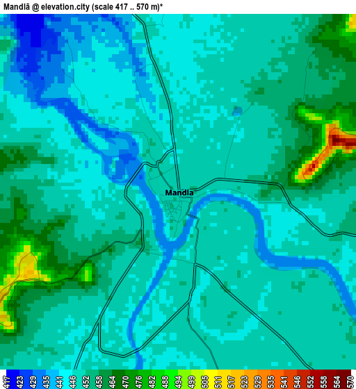
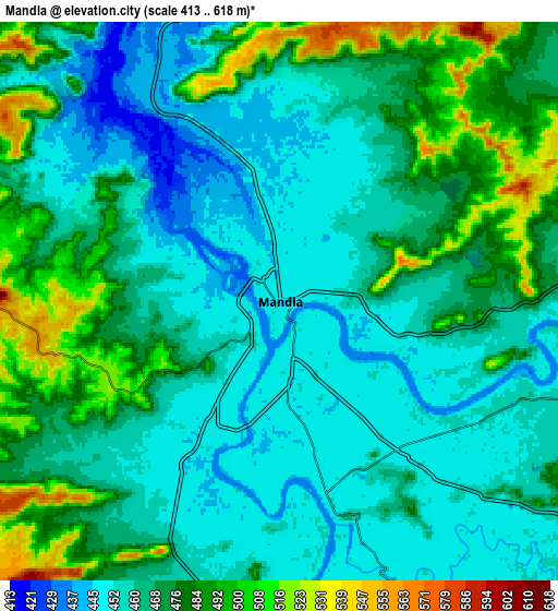
Below is the Elevation map of Mandlā, which displays elevation range with different colors. Scale of the first map is from 417 to 570 m (1368 to 1870 ft) with average elevation of 450.9 meters (=1479 ft) [note 1]
These maps also provides idea of topography and contour of this city, they are displayed at different zoom levels. More info about maps, scale and edge coordinates you can find below images.
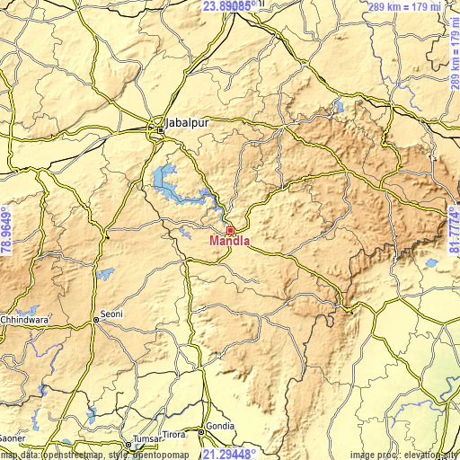
| \ | Map #1 | Map #2 | Topo.Map |
| Scale [m] | 417..570 m | 413..618 m | × |
| Scale [ft] | 1368..1870 ft | 1355..2028 ft | × |
| Average | 450.9 m = 1479 ft | 468.2 m = 1536 ft | × |
| Width | 9.02 km = 5.6 mi | 18.04 km = 11.2 mi | 288.7 km = 179.4 mi |
| Height | 9.02 km = 5.6 mi | 18.04 km = 11.2 mi | 288.7 km = 179.4 mi |
| ↑Max Latitude | 22.639355° | 22.679908° | 23.89085° |
| Latitude at center | 22.59879° | 22.59879° | 22.59879° |
| ↓Min Latitude | 22.558213° | 22.517624° | 21.29448° |
| ← Min Longitude | 80.327205° | 80.283259° | 78.9649° |
| Longitude center | 80.37115° | 80.37115° | 80.37115° |
| →Max Longitude | 80.415095° | 80.459041° | 81.7774° |
Nearby cities:
Cities around Mandlā sort by population:
• Jabalpur elevation 416 m
76.5 km,  325°
325°
• Panāgar 391 m
85.5 km, 333°
• Nainpur 448 m
33.1 km,  235°
235°
• Dindori 673 m
82 km,  62°
62°
• Bargi 401 m
67 km,  310°
310°
• Baihar 556 m
58.3 km,  161°
161°
• Lakhnādon 617 m
79.1 km,  270°
270°
• Khamaria 383 m
85.9 km,  324°
324°
• Barela 426 m
64.4 km, 329°
• Shāhpur 736 m
80.3 km,  53°
53°
• Ukwā 630 m
70.5 km,  172°
172°
• Ghansor 566 m
43.7 km,  278°
278°
Multilingual:
 En español:
Mandlā elevación 450 m.
 En France:
Mandlā élévation 450 m.


Sources and notes:
- [note 1] Map square and city borders are not equal. Map elevation data is calculated only from area inside that square.
- [src 1] Elevation data from geonames database provided with same terms of usage.
- [src 2] The elevation map of Mandlā is generated using elevation data from NASA's 3 arcsec (90m) resolution SRTM data.
- [src 3] Base (background) map © OpenStreetMap contributors tiles are generated by Geofabrik and OpenTopoMap.
Copyright & License:
This Mandlā Elevation Map is licensed under CC BY-SA. You may reuse any part from this page, if you give a proper credit by linking to this URL:
 More info on terms of use page.