Baihar elevation
Baihar (Madhya Pradesh, Bālāghāt), India elevation is 556 meters and Baihar elevation in feet is 1824 ft above sea level [src 1]. Baihar is a populated place (feature code) with elevation that is 263 meters (863 ft) bigger than average city elevation in India.
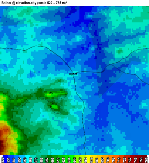
Below is the Elevation map of Baihar, which displays elevation range with different colors. Scale of the first map is from 522 to 765 m (1713 to 2510 ft) with average elevation of 561.3 meters (=1842 ft) [note 1]
These maps also provides idea of topography and contour of this city, they are displayed at different zoom levels. More info about maps, scale and edge coordinates you can find below images.
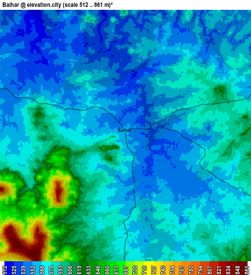
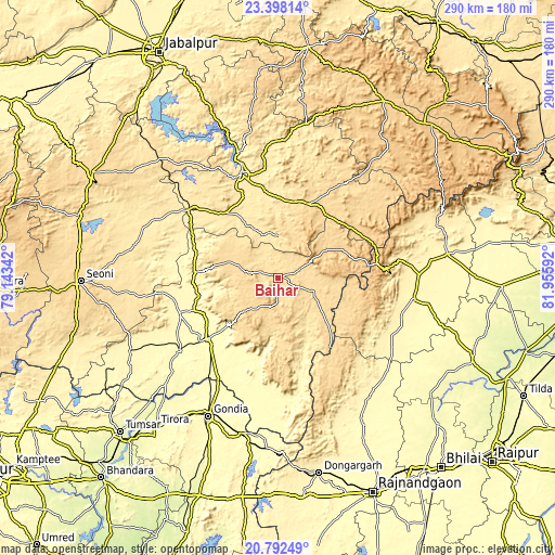
| \ | Map #1 | Map #2 | Topo.Map |
| Scale [m] | 522..765 m | 512..861 m | × |
| Scale [ft] | 1713..2510 ft | 1680..2825 ft | × |
| Average | 561.3 m = 1842 ft | 576.7 m = 1892 ft | × |
| Width | 9.05 km = 5.6 mi | 18.11 km = 11.3 mi | 289.7 km = 180 mi |
| Height | 9.05 km = 5.6 mi | 18.11 km = 11.3 mi | 289.7 km = 180 mi |
| ↑Max Latitude | 22.14204° | 22.182739° | 23.39814° |
| Latitude at center | 22.10133° | 22.10133° | 22.10133° |
| ↓Min Latitude | 22.060608° | 22.019874° | 20.79249° |
| ← Min Longitude | 80.505725° | 80.461779° | 79.14342° |
| Longitude center | 80.54967° | 80.54967° | 80.54967° |
| →Max Longitude | 80.593615° | 80.637561° | 81.95592° |
Nearby cities:
Cities around Baihar sort by population:
• Gondiā elevation 322 m
80.3 km,  207°
207°
• Bālāghāt 319 m
49 km,  229°
229°
• Mandlā 450 m
58.3 km,  341°
341°
• Kawardha 356 m
71 km,  98°
98°
• Wārāseonī 307 m
64.5 km, 234°
• Nainpur 448 m
58.5 km,  308°
308°
• Katangi 351 m
85 km,  244°
244°
• Gandai 327 m
74.6 km,  130°
130°
• Barghāt 538 m
84.5 km,  264°
264°
• Pāndātarai 357 m
80.7 km,  83°
83°
• Ukwā 630 m
16.8 km, 210°
• Chhuīkhadān 338 m
79.2 km,  144°
144°
Multilingual:
 En español:
Baihar elevación 556 m.
 En France:
Baihar élévation 556 m.


Sources and notes:
- [note 1] Map square and city borders are not equal. Map elevation data is calculated only from area inside that square.
- [src 1] Elevation data from geonames database provided with same terms of usage.
- [src 2] The elevation map of Baihar is generated using elevation data from NASA's 3 arcsec (90m) resolution SRTM data.
- [src 3] Base (background) map © OpenStreetMap contributors tiles are generated by Geofabrik and OpenTopoMap.
Copyright & License:
This Baihar Elevation Map is licensed under CC BY-SA. You may reuse any part from this page, if you give a proper credit by linking to this URL:
 More info on terms of use page.