Barela elevation
Barela (Madhya Pradesh, Jabalpur), India elevation is 426 meters and Barela elevation in feet is 1398 ft above sea level [src 1]. Barela is a populated place (feature code) with elevation that is 133 meters (436 ft) bigger than average city elevation in India.
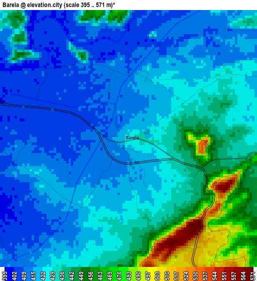
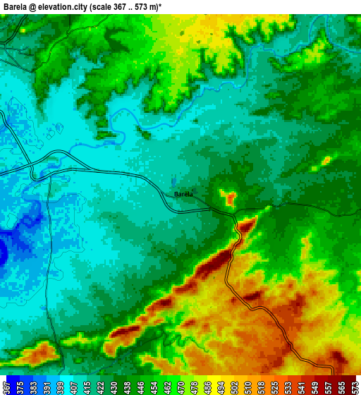
Below is the Elevation map of Barela, which displays elevation range with different colors. Scale of the first map is from 395 to 571 m (1296 to 1873 ft) with average elevation of 427.5 meters (=1403 ft) [note 1]
These maps also provides idea of topography and contour of this city, they are displayed at different zoom levels. More info about maps, scale and edge coordinates you can find below images.
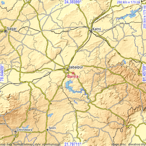
| \ | Map #1 | Map #2 | Topo.Map |
| Scale [m] | 395..571 m | 367..573 m | × |
| Scale [ft] | 1296..1873 ft | 1204..1880 ft | × |
| Average | 427.5 m = 1403 ft | 441.8 m = 1449 ft | × |
| Width | 8.99 km = 5.6 mi | 17.98 km = 11.2 mi | 287.6 km = 178.7 mi |
| Height | 8.99 km = 5.6 mi | 17.98 km = 11.2 mi | 287.6 km = 178.7 mi |
| ↑Max Latitude | 23.137197° | 23.177601° | 24.38399° |
| Latitude at center | 23.09678° | 23.09678° | 23.09678° |
| ↓Min Latitude | 23.056351° | 23.01591° | 21.79711° |
| ← Min Longitude | 80.006895° | 79.962949° | 78.64459° |
| Longitude center | 80.05084° | 80.05084° | 80.05084° |
| →Max Longitude | 80.094785° | 80.138731° | 81.45709° |
Nearby cities:
Cities around Barela sort by population:
• Jabalpur elevation 416 m
12.9 km,  307°
307°
• Sihorā 391 m
43.7 km,  7°
7°
• Panāgar 391 m
21.7 km,  344°
344°
• Kaimori 374 m
44.8 km,  315°
315°
• Katangi 373 m
46.3 km,  325°
325°
• Bargi 401 m
21.4 km,  236°
236°
• Khamaria 383 m
22.6 km, 309°
• Pātan 378 m
42.5 km,  299°
299°
• Shāhpura 379 m
39.8 km,  276°
276°
• Tendūkheda 398 m
61.9 km, 302°
• Majholi 394 m
46.8 km, 343°
• Ghansor 566 m
49.7 km,  191°
191°
Multilingual:
 En español:
Barela elevación 426 m.
 En France:
Barela élévation 426 m.


Sources and notes:
- [note 1] Map square and city borders are not equal. Map elevation data is calculated only from area inside that square.
- [src 1] Elevation data from geonames database provided with same terms of usage.
- [src 2] The elevation map of Barela is generated using elevation data from NASA's 3 arcsec (90m) resolution SRTM data.
- [src 3] Base (background) map © OpenStreetMap contributors tiles are generated by Geofabrik and OpenTopoMap.
Copyright & License:
This Barela Elevation Map is licensed under CC BY-SA. You may reuse any part from this page, if you give a proper credit by linking to this URL:
 More info on terms of use page.