Dindori elevation
Dindori (Madhya Pradesh), India elevation is 673 meters and Dindori elevation in feet is 2208 ft above sea level [src 1]. Dindori is a populated place (feature code) with elevation that is 380 meters (1247 ft) bigger than average city elevation in India.
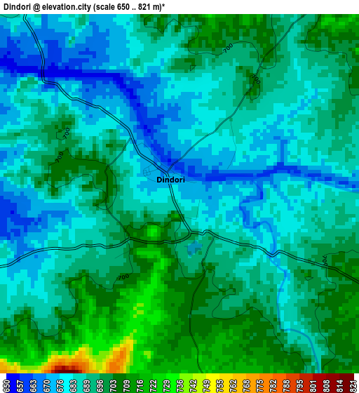
Below is the Elevation map of Dindori, which displays elevation range with different colors. Scale of the first map is from 650 to 821 m (2133 to 2694 ft) with average elevation of 691.3 meters (=2268 ft) [note 1]
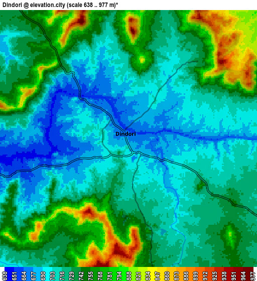
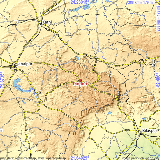
These maps also provides idea of topography and contour of this city, they are displayed at different zoom levels. More info about maps, scale and edge coordinates you can find below images.
| \ | Map #1 | Map #2 | Topo.Map |
| Scale [m] | 650..821 m | 638..977 m | × |
| Scale [ft] | 2133..2694 ft | 2093..3205 ft | × |
| Average | 691.3 m = 2268 ft | 732.3 m = 2403 ft | × |
| Width | 9 km = 5.6 mi | 18 km = 11.2 mi | 288 km = 179 mi |
| Height | 9 km = 5.6 mi | 18 km = 11.2 mi | 288 km = 179 mi |
| ↑Max Latitude | 22.981873° | 23.022325° | 24.23015° |
| Latitude at center | 22.94141° | 22.94141° | 22.94141° |
| ↓Min Latitude | 22.900935° | 22.860447° | 21.64029° |
| ← Min Longitude | 81.035805° | 80.991859° | 79.6735° |
| Longitude center | 81.07975° | 81.07975° | 81.07975° |
| →Max Longitude | 81.123695° | 81.167641° | 82.486° |
Nearby cities:
Cities around Dindori sort by population:
• Shahdol elevation 468 m
48.6 km,  36°
36°
• Mandlā 450 m
82 km,  242°
242°
• Umaria 463 m
69.4 km,  339°
339°
• Pāli 467 m
47.2 km,  355°
355°
• Burhar 486 m
55.4 km,  56°
56°
• Anūppur 503 m
65.1 km,  73°
73°
• Gaurela 622 m
86.7 km,  103°
103°
• Bodri 503 m
43.8 km, 55°
• Pandaria 345 m
86.6 km,  156°
156°
• Pāndātarai 357 m
87.7 km, 163°
• Shāhpur 736 m
12.1 km,  319°
319°
• Amarkantak 1042 m
75.7 km,  113°
113°
Multilingual:
 En español:
Dindori elevación 673 m.
 En France:
Dindori élévation 673 m.


Sources and notes:
- [note 1] Map square and city borders are not equal. Map elevation data is calculated only from area inside that square.
- [src 1] Elevation data from geonames database provided with same terms of usage.
- [src 2] The elevation map of Dindori is generated using elevation data from NASA's 3 arcsec (90m) resolution SRTM data.
- [src 3] Base (background) map © OpenStreetMap contributors tiles are generated by Geofabrik and OpenTopoMap.
Copyright & License:
This Dindori Elevation Map is licensed under CC BY-SA. You may reuse any part from this page, if you give a proper credit by linking to this URL:
 More info on terms of use page.