Marayur elevation
Marayur (Kerala, Idukki), India elevation is 989 meters and Marayur elevation in feet is 3245 ft above sea level [src 1]. Marayur is a populated place (feature code) with elevation that is 696 meters (2283 ft) bigger than average city elevation in India.
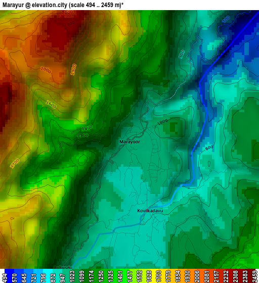
Below is the Elevation map of Marayur, which displays elevation range with different colors. Scale of the first map is from 494 to 2459 m (1621 to 8068 ft) with average elevation of 1241.1 meters (=4072 ft) [note 1]
These maps also provides idea of topography and contour of this city, they are displayed at different zoom levels. More info about maps, scale and edge coordinates you can find below images.
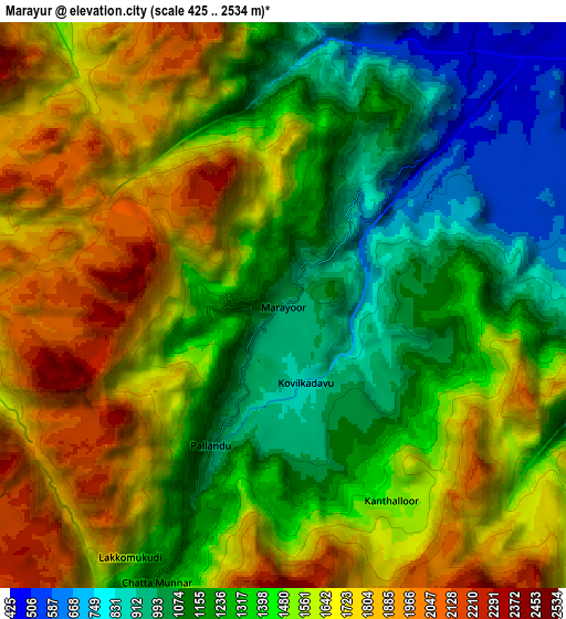
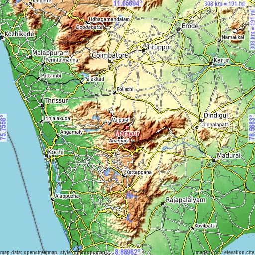
| \ | Map #1 | Map #2 | Topo.Map |
| Scale [m] | 494..2459 m | 425..2534 m | × |
| Scale [ft] | 1621..8068 ft | 1394..8314 ft | × |
| Average | 1241.1 m = 4072 ft | 1456.4 m = 4778 ft | × |
| Width | 9.62 km = 6 mi | 19.23 km = 11.9 mi | 307.7 km = 191.2 mi |
| Height | 9.62 km = 6 mi | 19.23 km = 11.9 mi | 307.7 km = 191.2 mi |
| ↑Max Latitude | 10.319647° | 10.362879° | 11.65694° |
| Latitude at center | 10.27641° | 10.27641° | 10.27641° |
| ↓Min Latitude | 10.233167° | 10.189917° | 8.88982° |
| ← Min Longitude | 77.118105° | 77.074159° | 75.7558° |
| Longitude center | 77.16205° | 77.16205° | 77.16205° |
| →Max Longitude | 77.205995° | 77.249941° | 78.5683° |
Nearby cities:
Cities around Marayur sort by population:
• Teni elevation 300 m
45.4 km,  130°
130°
• Valparai 1062 m
23.7 km,  283°
283°
• Bodināyakkanūr 352 m
35.9 km,  145°
145°
• Munnar 1470 m
23.6 km,  207°
207°
• Palani 328 m
43.8 km,  63°
63°
• Udumalaippettai 363 m
35.9 km,  15°
15°
• Periyakulam 281 m
45.1 km,  112°
112°
• Kodaikānāl 2098 m
36 km,  96°
96°
• Vettaikkaranpudur 284 m
41.8 km,  319°
319°
• Anamalais 264 m
42.2 km, 323°
• Kumaralingam 323 m
31.3 km,  40°
40°
• Dhali 391 m
26.2 km,  6°
6°
Multilingual:
 En español:
Marayur elevación 989 m.
 En France:
Marayur élévation 989 m.


Sources and notes:
- [note 1] Map square and city borders are not equal. Map elevation data is calculated only from area inside that square.
- [src 1] Elevation data from geonames database provided with same terms of usage.
- [src 2] The elevation map of Marayur is generated using elevation data from NASA's 3 arcsec (90m) resolution SRTM data.
- [src 3] Base (background) map © OpenStreetMap contributors tiles are generated by Geofabrik and OpenTopoMap.
Copyright & License:
This Marayur Elevation Map is licensed under CC BY-SA. You may reuse any part from this page, if you give a proper credit by linking to this URL:
 More info on terms of use page.