Valparai elevation
Valparai (Tamil Nadu, Coimbatore), India elevation is 1062 meters and Valparai elevation in feet is 3484 ft above sea level [src 1]. Valparai is a populated place (feature code) with elevation that is 769 meters (2523 ft) bigger than average city elevation in India.
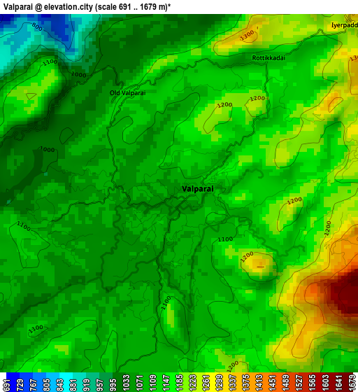
Below is the Elevation map of Valparai, which displays elevation range with different colors. Scale of the first map is from 691 to 1679 m (2267 to 5509 ft) with average elevation of 1120.9 meters (=3677 ft) [note 1]
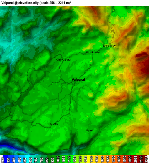
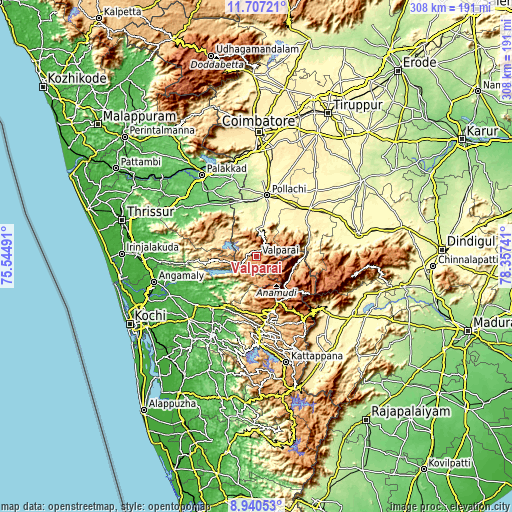
These maps also provides idea of topography and contour of this city, they are displayed at different zoom levels. More info about maps, scale and edge coordinates you can find below images.
| \ | Map #1 | Map #2 | Topo.Map |
| Scale [m] | 691..1679 m | 256..2211 m | × |
| Scale [ft] | 2267..5509 ft | 840..7254 ft | × |
| Average | 1120.9 m = 3677 ft | 1133.7 m = 3719 ft | × |
| Width | 9.61 km = 6 mi | 19.23 km = 11.9 mi | 307.6 km = 191.1 mi |
| Height | 9.61 km = 6 mi | 19.23 km = 11.9 mi | 307.7 km = 191.2 mi |
| ↑Max Latitude | 10.37014° | 10.413365° | 11.70721° |
| Latitude at center | 10.32691° | 10.32691° | 10.32691° |
| ↓Min Latitude | 10.283674° | 10.240431° | 8.94053° |
| ← Min Longitude | 76.907215° | 76.863269° | 75.54491° |
| Longitude center | 76.95116° | 76.95116° | 76.95116° |
| →Max Longitude | 76.995105° | 77.039051° | 78.35741° |
Nearby cities:
Cities around Valparai sort by population:
• Pollachi elevation 294 m
37.4 km,  9°
9°
• Munnar 1470 m
29.2 km,  155°
155°
• Udumalaippettai 363 m
43.5 km,  48°
48°
• Kotamangalam 26 m
45.8 km,  230°
230°
• Chittūr 136 m
47.1 km,  331°
331°
• Kuttampuzha 48 m
30.7 km, 230°
• Marayur 989 m
23.7 km,  103°
103°
• Vettaikkaranpudur 284 m
26.5 km,  350°
350°
• Anamalais 264 m
28.5 km,  356°
356°
• Kumaralingam 323 m
47.2 km,  67°
67°
• Periyanegamam 357 m
49.2 km,  19°
19°
• Dhali 391 m
33 km, 51°
Multilingual:
 En español:
Valparai elevación 1062 m.
 En France:
Valparai élévation 1062 m.
 Auf Deutsch:
Valparai höhe über dem Meeresspiegel ist 1062 m.

Sources and notes:
- [note 1] Map square and city borders are not equal. Map elevation data is calculated only from area inside that square.
- [src 1] Elevation data from geonames database provided with same terms of usage.
- [src 2] The elevation map of Valparai is generated using elevation data from NASA's 3 arcsec (90m) resolution SRTM data.
- [src 3] Base (background) map © OpenStreetMap contributors tiles are generated by Geofabrik and OpenTopoMap.
Copyright & License:
This Valparai Elevation Map is licensed under CC BY-SA. You may reuse any part from this page, if you give a proper credit by linking to this URL:
 More info on terms of use page.