Munnar elevation
Munnar (Kerala, Idukki), India elevation is 1470 meters and Munnar elevation in feet is 4823 ft above sea level [src 1]. Munnar is a populated place (feature code) with elevation that is 1177 meters (3862 ft) bigger than average city elevation in India.
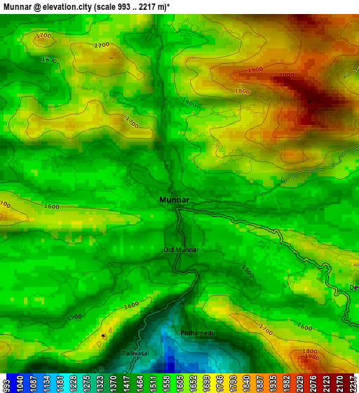
Below is the Elevation map of Munnar, which displays elevation range with different colors. Scale of the first map is from 993 to 2217 m (3258 to 7274 ft) with average elevation of 1612.1 meters (=5289 ft) [note 1]
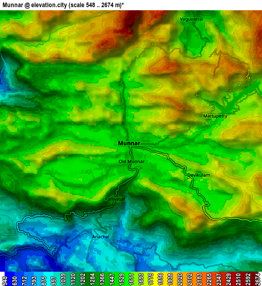
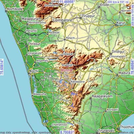
These maps also provides idea of topography and contour of this city, they are displayed at different zoom levels. More info about maps, scale and edge coordinates you can find below images.
| \ | Map #1 | Map #2 | Topo.Map |
| Scale [m] | 993..2217 m | 548..2674 m | × |
| Scale [ft] | 3258..7274 ft | 1798..8773 ft | × |
| Average | 1612.1 m = 5289 ft | 1519.9 m = 4987 ft | × |
| Width | 9.62 km = 6 mi | 19.24 km = 12 mi | 307.9 km = 191.3 mi |
| Height | 9.62 km = 6 mi | 19.24 km = 12 mi | 307.9 km = 191.3 mi |
| ↑Max Latitude | 10.131443° | 10.1747° | 11.46958° |
| Latitude at center | 10.08818° | 10.08818° | 10.08818° |
| ↓Min Latitude | 10.044911° | 10.001637° | 8.70083° |
| ← Min Longitude | 77.018445° | 76.974499° | 75.65614° |
| Longitude center | 77.06239° | 77.06239° | 77.06239° |
| →Max Longitude | 77.106335° | 77.150281° | 78.46864° |
Nearby cities:
Cities around Munnar sort by population:
• Teni elevation 300 m
46.3 km,  100°
100°
• Valparai 1062 m
29.2 km,  335°
335°
• Bodināyakkanūr 352 m
32.6 km,  105°
105°
• Cumbum 417 m
46.1 km,  148°
148°
• Chinnamanūr 366 m
44.5 km,  128°
128°
• Kotamangalam 26 m
47.6 km,  266°
266°
• Kuttampuzha 48 m
36.4 km,  280°
280°
• Marayur 989 m
23.6 km,  27°
27°
• Uttamapālaiyam 386 m
42.6 km,  137°
137°
• Kombai 430 m
37 km, 136°
• Idukki 610 m
28.5 km,  201°
201°
• Dhali 391 m
48.9 km,  16°
16°
Multilingual:
 En español:
Munnar elevación 1470 m.
 En France:
Munnar élévation 1470 m.


Sources and notes:
- [note 1] Map square and city borders are not equal. Map elevation data is calculated only from area inside that square.
- [src 1] Elevation data from geonames database provided with same terms of usage.
- [src 2] The elevation map of Munnar is generated using elevation data from NASA's 3 arcsec (90m) resolution SRTM data.
- [src 3] Base (background) map © OpenStreetMap contributors tiles are generated by Geofabrik and OpenTopoMap.
Copyright & License:
This Munnar Elevation Map is licensed under CC BY-SA. You may reuse any part from this page, if you give a proper credit by linking to this URL:
 More info on terms of use page.