Chinnamanūr elevation
Chinnamanūr (Tamil Nadu, Theni), India elevation is 366 meters and Chinnamanūr elevation in feet is 1201 ft above sea level [src 1]. Chinnamanūr is a populated place (feature code) with elevation that is 73 meters (240 ft) bigger than average city elevation in India.
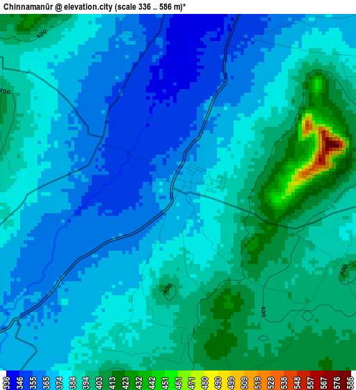
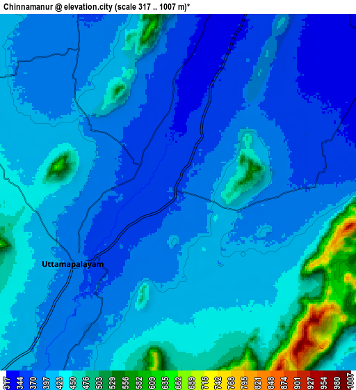
Below is the Elevation map of Chinnamanūr, which displays elevation range with different colors. Scale of the first map is from 336 to 586 m (1102 to 1923 ft) with average elevation of 381.8 meters (=1253 ft) [note 1]
These maps also provides idea of topography and contour of this city, they are displayed at different zoom levels. More info about maps, scale and edge coordinates you can find below images.
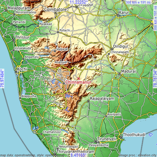
| \ | Map #1 | Map #2 | Topo.Map |
| Scale [m] | 336..586 m | 317..1007 m | × |
| Scale [ft] | 1102..1923 ft | 1040..3304 ft | × |
| Average | 381.8 m = 1253 ft | 410.9 m = 1348 ft | × |
| Width | 9.63 km = 6 mi | 19.26 km = 12 mi | 308.1 km = 191.4 mi |
| Height | 9.63 km = 6 mi | 19.26 km = 12 mi | 308.1 km = 191.4 mi |
| ↑Max Latitude | 9.883286° | 9.926576° | 11.22252° |
| Latitude at center | 9.83999° | 9.83999° | 9.83999° |
| ↓Min Latitude | 9.796688° | 9.753381° | 8.45165° |
| ← Min Longitude | 77.337145° | 77.293199° | 75.97484° |
| Longitude center | 77.38109° | 77.38109° | 77.38109° |
| →Max Longitude | 77.425035° | 77.468981° | 78.78734° |
Nearby cities:
Cities around Chinnamanūr sort by population:
• Teni elevation 300 m
21.8 km,  29°
29°
• Bodināyakkanūr 352 m
19.4 km,  349°
349°
• Munnar 1470 m
44.5 km,  308°
308°
• Cumbum 417 m
15.6 km,  222°
222°
• Gudalur 454 m
23 km, 218°
• Periyakulam 281 m
36.1 km, 29°
• Āndippatti 291 m
31.6 km,  56°
56°
• Uttamapālaiyam 386 m
7 km,  238°
238°
• Elumalai 214 m
35 km,  85°
85°
• Devadānappatti 294 m
44.6 km,  40°
40°
• Kombai 430 m
9.4 km,  275°
275°
• Idukki 610 m
45.4 km,  271°
271°
Multilingual:
 En español:
Chinnamanūr elevación 366 m.
 En France:
Chinnamanūr élévation 366 m.
 Auf Deutsch:
Chinnamanūr höhe über dem Meeresspiegel ist 366 m.

Sources and notes:
- [note 1] Map square and city borders are not equal. Map elevation data is calculated only from area inside that square.
- [src 1] Elevation data from geonames database provided with same terms of usage.
- [src 2] The elevation map of Chinnamanūr is generated using elevation data from NASA's 3 arcsec (90m) resolution SRTM data.
- [src 3] Base (background) map © OpenStreetMap contributors tiles are generated by Geofabrik and OpenTopoMap.
Copyright & License:
This Chinnamanūr Elevation Map is licensed under CC BY-SA. You may reuse any part from this page, if you give a proper credit by linking to this URL:
 More info on terms of use page.