Mhāsvād elevation
Mhāsvād (Maharashtra, Satara Division), India elevation is 609 meters and Mhāsvād elevation in feet is 1998 ft above sea level [src 1]. Mhāsvād is a populated place (feature code) with elevation that is 316 meters (1037 ft) bigger than average city elevation in India.
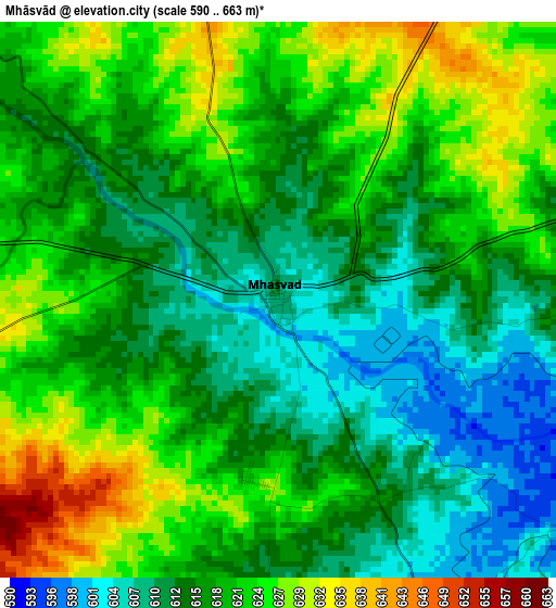
Below is the Elevation map of Mhāsvād, which displays elevation range with different colors. Scale of the first map is from 590 to 663 m (1936 to 2175 ft) with average elevation of 617.9 meters (=2027 ft) [note 1]
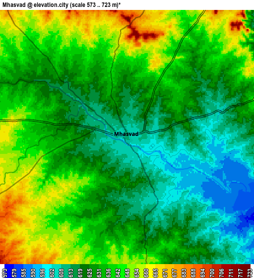
These maps also provides idea of topography and contour of this city, they are displayed at different zoom levels. More info about maps, scale and edge coordinates you can find below images.

| \ | Map #1 | Map #2 | Topo.Map |
| Scale [m] | 590..663 m | 573..723 m | × |
| Scale [ft] | 1936..2175 ft | 1880..2372 ft | × |
| Average | 617.9 m = 2027 ft | 632 m = 2073 ft | × |
| Width | 9.31 km = 5.8 mi | 18.63 km = 11.6 mi | 298 km = 185.2 mi |
| Height | 9.31 km = 5.8 mi | 18.63 km = 11.6 mi | 298 km = 185.2 mi |
| ↑Max Latitude | 17.675466° | 17.717331° | 18.96867° |
| Latitude at center | 17.63359° | 17.63359° | 17.63359° |
| ↓Min Latitude | 17.591705° | 17.54981° | 16.28854° |
| ← Min Longitude | 74.743785° | 74.699839° | 73.38148° |
| Longitude center | 74.78773° | 74.78773° | 74.78773° |
| →Max Longitude | 74.831675° | 74.875621° | 76.19398° |
Nearby cities:
Cities around Mhāsvād sort by population:
• Pandharpur elevation 456 m
57.8 km,  84°
84°
• Karād 579 m
74.8 km,  239°
239°
• Bārāmati 552 m
61.8 km,  338°
338°
• Phaltan 560 m
54.8 km,  316°
316°
• Vite 689 m
48 km,  213°
213°
• Tāsgaon 586 m
69.2 km,  196°
196°
• Malkapur 579 m
76.9 km, 237°
• Sāngola 502 m
48.2 km,  116°
116°
• Rahimatpur 649 m
62.5 km,  265°
265°
• Bhudgaon 569 m
83.2 km,  193°
193°
• Kalas 560 m
59.9 km,  0°
0°
• Bhigvan 501 m
74.2 km,  358°
358°
Multilingual:
 En español:
Mhāsvād elevación 609 m.
 En France:
Mhāsvād élévation 609 m.


Sources and notes:
- [note 1] Map square and city borders are not equal. Map elevation data is calculated only from area inside that square.
- [src 1] Elevation data from geonames database provided with same terms of usage.
- [src 2] The elevation map of Mhāsvād is generated using elevation data from NASA's 3 arcsec (90m) resolution SRTM data.
- [src 3] Base (background) map © OpenStreetMap contributors tiles are generated by Geofabrik and OpenTopoMap.
Copyright & License:
This Mhāsvād Elevation Map is licensed under CC BY-SA. You may reuse any part from this page, if you give a proper credit by linking to this URL:
 More info on terms of use page.