Sāngola elevation
Sāngola (Maharashtra, Solapur), India elevation is 502 meters and Sāngola elevation in feet is 1647 ft above sea level [src 1]. Sāngola is a populated place (feature code) with elevation that is 209 meters (686 ft) bigger than average city elevation in India.
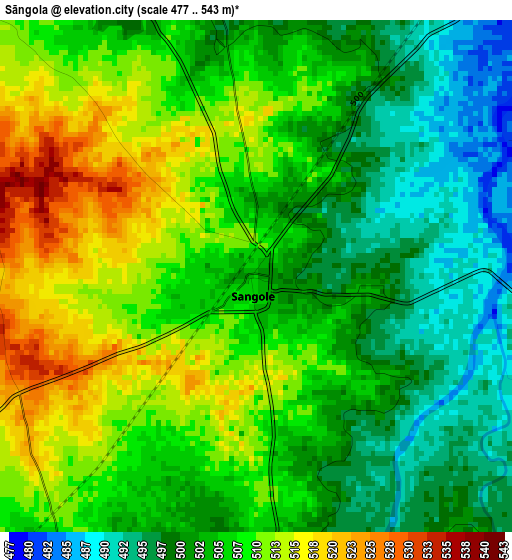
Below is the Elevation map of Sāngola, which displays elevation range with different colors. Scale of the first map is from 477 to 543 m (1565 to 1781 ft) with average elevation of 505.5 meters (=1658 ft) [note 1]
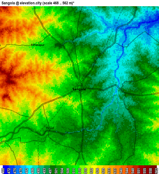
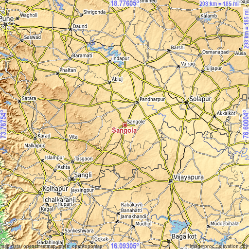
These maps also provides idea of topography and contour of this city, they are displayed at different zoom levels. More info about maps, scale and edge coordinates you can find below images.
| \ | Map #1 | Map #2 | Topo.Map |
| Scale [m] | 477..543 m | 468..562 m | × |
| Scale [ft] | 1565..1781 ft | 1535..1844 ft | × |
| Average | 505.5 m = 1658 ft | 507.8 m = 1666 ft | × |
| Width | 9.32 km = 5.8 mi | 18.65 km = 11.6 mi | 298.3 km = 185.4 mi |
| Height | 9.32 km = 5.8 mi | 18.65 km = 11.6 mi | 298.3 km = 185.4 mi |
| ↑Max Latitude | 17.481401° | 17.523311° | 18.77605° |
| Latitude at center | 17.43948° | 17.43948° | 17.43948° |
| ↓Min Latitude | 17.39755° | 17.35561° | 16.09305° |
| ← Min Longitude | 75.149845° | 75.105899° | 73.78754° |
| Longitude center | 75.19379° | 75.19379° | 75.19379° |
| →Max Longitude | 75.237735° | 75.281681° | 76.60004° |
Nearby cities:
Cities around Sāngola sort by population:
• Solāpur elevation 473 m
80.2 km,  71°
71°
• Sāngli 553 m
93.3 km,  225°
225°
• Bijapur 606 m
88 km,  140°
140°
• Pandharpur 456 m
30.4 km,  28°
28°
• Vite 689 m
72 km,  255°
255°
• Athni 573 m
80.5 km,  189°
189°
• Tāsgaon 586 m
77.2 km, 234°
• Indi 466 m
85.7 km,  109°
109°
• Kurduvādi 516 m
76.4 km,  17°
17°
• Mhāsvād 609 m
48.2 km,  296°
296°
• Bhudgaon 569 m
86.5 km, 226°
• Kalas 560 m
92 km,  332°
332°
Multilingual:
 En español:
Sāngola elevación 502 m.
 En France:
Sāngola élévation 502 m.


Sources and notes:
- [note 1] Map square and city borders are not equal. Map elevation data is calculated only from area inside that square.
- [src 1] Elevation data from geonames database provided with same terms of usage.
- [src 2] The elevation map of Sāngola is generated using elevation data from NASA's 3 arcsec (90m) resolution SRTM data.
- [src 3] Base (background) map © OpenStreetMap contributors tiles are generated by Geofabrik and OpenTopoMap.
Copyright & License:
This Sāngola Elevation Map is licensed under CC BY-SA. You may reuse any part from this page, if you give a proper credit by linking to this URL:
 More info on terms of use page.