Tāsgaon elevation
Tāsgaon (Maharashtra, Sangli), India elevation is 586 meters and Tāsgaon elevation in feet is 1923 ft above sea level [src 1]. Tāsgaon is a populated place (feature code) with elevation that is 293 meters (961 ft) bigger than average city elevation in India.
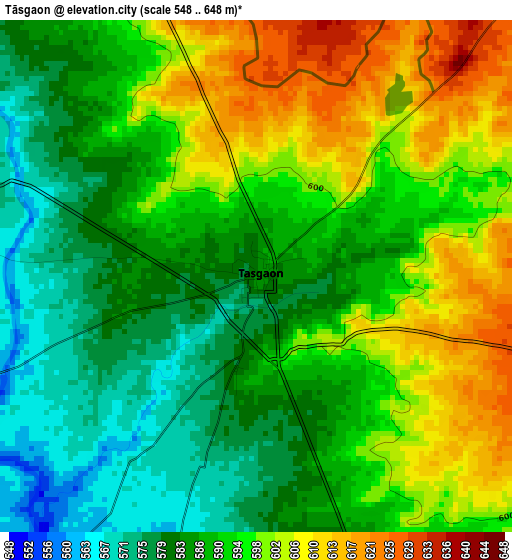
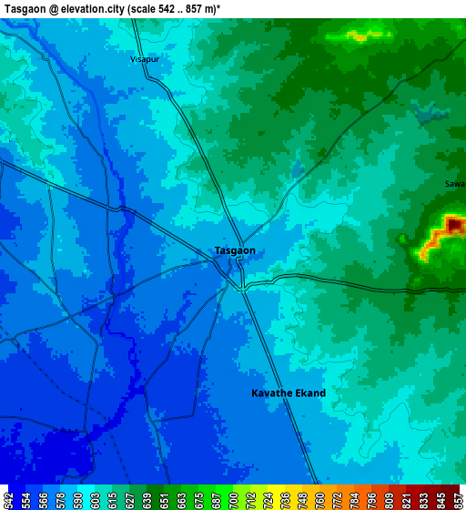
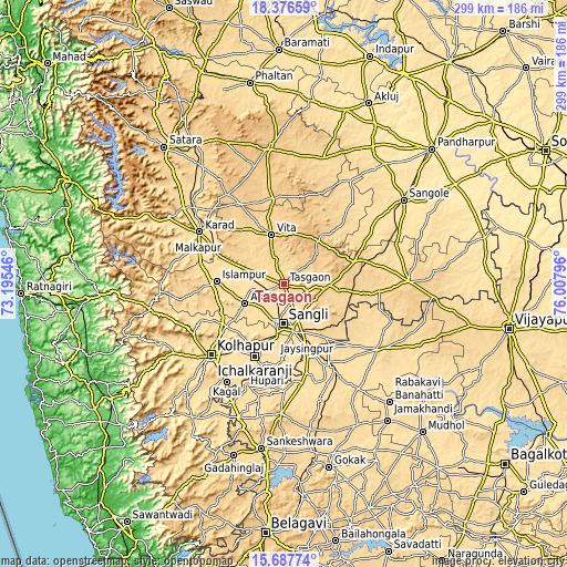
Below is the Elevation map of Tāsgaon, which displays elevation range with different colors. Scale of the first map is from 548 to 648 m (1798 to 2126 ft) with average elevation of 591.8 meters (=1942 ft) [note 1]
These maps also provides idea of topography and contour of this city, they are displayed at different zoom levels. More info about maps, scale and edge coordinates you can find below images.
| \ | Map #1 | Map #2 | Topo.Map |
| Scale [m] | 548..648 m | 542..857 m | × |
| Scale [ft] | 1798..2126 ft | 1778..2812 ft | × |
| Average | 591.8 m = 1942 ft | 597.6 m = 1961 ft | × |
| Width | 9.34 km = 5.8 mi | 18.69 km = 11.6 mi | 299 km = 185.8 mi |
| Height | 9.34 km = 5.8 mi | 18.69 km = 11.6 mi | 299 km = 185.8 mi |
| ↑Max Latitude | 17.079012° | 17.121015° | 18.37659° |
| Latitude at center | 17.037° | 17.037° | 17.037° |
| ↓Min Latitude | 16.994978° | 16.952948° | 15.68774° |
| ← Min Longitude | 74.557765° | 74.513819° | 73.19546° |
| Longitude center | 74.60171° | 74.60171° | 74.60171° |
| →Max Longitude | 74.645655° | 74.689601° | 76.00796° |
Nearby cities:
Cities around Tāsgaon sort by population:
• Sāngli elevation 553 m
20.7 km,  191°
191°
• Ichalkaranji 561 m
41.3 km,  201°
201°
• Karād 579 m
52.7 km,  302°
302°
• Jaisingpur 558 m
29.4 km, 190°
• Vite 689 m
27.1 km,  345°
345°
• Ashta 575 m
22.7 km,  244°
244°
• Malkapur 579 m
51.7 km, 298°
• Shiraguppi 540 m
47.9 km,  166°
166°
• Kurandvād 546 m
39.4 km,  181°
181°
• Kudachi 547 m
52.8 km,  149°
149°
• Kodoli 566 m
47.2 km,  247°
247°
• Bhudgaon 569 m
14.4 km, 180°
Multilingual:
 En español:
Tāsgaon elevación 586 m.
 En France:
Tāsgaon élévation 586 m.


Sources and notes:
- [note 1] Map square and city borders are not equal. Map elevation data is calculated only from area inside that square.
- [src 1] Elevation data from geonames database provided with same terms of usage.
- [src 2] The elevation map of Tāsgaon is generated using elevation data from NASA's 3 arcsec (90m) resolution SRTM data.
- [src 3] Base (background) map © OpenStreetMap contributors tiles are generated by Geofabrik and OpenTopoMap.
Copyright & License:
This Tāsgaon Elevation Map is licensed under CC BY-SA. You may reuse any part from this page, if you give a proper credit by linking to this URL:
 More info on terms of use page.