Morādābād elevation
Morādābād (Uttar Pradesh), India elevation is 205 meters and Morādābād elevation in feet is 673 ft above sea level [src 1]. Morādābād is a seat of a second-order administrative division (feature code) with elevation that is 88 meters (289 ft) smaller than average city elevation in India.
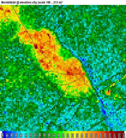
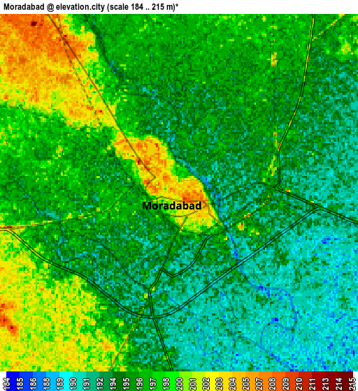
Below is the Elevation map of Morādābād, which displays elevation range with different colors. Scale of the first map is from 186 to 213 m (610 to 699 ft) with average elevation of 195.7 meters (=642 ft) [note 1]
These maps also provides idea of topography and contour of this city, they are displayed at different zoom levels. More info about maps, scale and edge coordinates you can find below images.
| \ | Map #1 | Map #2 | Topo.Map |
| Scale [m] | 186..213 m | 184..215 m | × |
| Scale [ft] | 610..699 ft | 604..705 ft | × |
| Average | 195.7 m = 642 ft | 195.7 m = 642 ft | × |
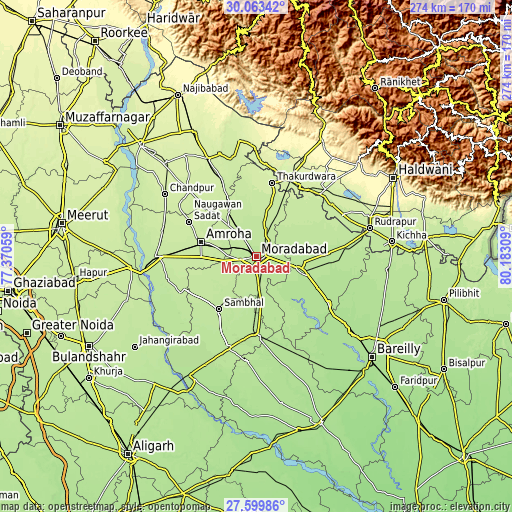
| Width | 8.56 km = 5.3 mi | 17.12 km = 10.6 mi | 273.9 km = 170.2 mi |
| Height | 8.56 km = 5.3 mi | 17.12 km = 10.6 mi | 273.9 km = 170.2 mi |
| ↑Max Latitude | 28.877418° | 28.915892° | 30.06342° |
| Latitude at center | 28.83893° | 28.83893° | 28.83893° |
| ↓Min Latitude | 28.800428° | 28.761911° | 27.59986° |
| ← Min Longitude | 78.732895° | 78.688949° | 77.37059° |
| Longitude center | 78.77684° | 78.77684° | 78.77684° |
| →Max Longitude | 78.820785° | 78.864731° | 80.18309° |
Nearby cities:
Cities around Morādābād sort by population:
• Rāmpur elevation 196 m
24.6 km,  97°
97°
• Sambhal 203 m
34.7 km,  215°
215°
• Amroha 218 m
30.7 km,  283°
283°
• Tānda 208 m
22.2 km,  46°
46°
• Shāhābād 189 m
37.8 km,  143°
143°
• Bilāri 198 m
24.3 km,  173°
173°
• Suār 211 m
34.4 km, 52°
• Kundarkhi 198 m
17.4 km,  177°
177°
• Kānth 219 m
28.4 km,  329°
329°
• Sahaspur 224 m
34.8 km, 334°
• Sirsi 202 m
25.8 km,  210°
210°
• Narauli 195 m
39.8 km,  188°
188°
Multilingual:
 En español:
Morādābād elevación 205 m.
 En France:
Morādābād élévation 205 m.
 Auf Deutsch:
Morādābād höhe über dem Meeresspiegel ist 205 m.

Sources and notes:
- [note 1] Map square and city borders are not equal. Map elevation data is calculated only from area inside that square.
- [src 1] Elevation data from geonames database provided with same terms of usage.
- [src 2] The elevation map of Morādābād is generated using elevation data from NASA's 3 arcsec (90m) resolution SRTM data.
- [src 3] Base (background) map © OpenStreetMap contributors tiles are generated by Geofabrik and OpenTopoMap.
Copyright & License:
This Morādābād Elevation Map is licensed under CC BY-SA. You may reuse any part from this page, if you give a proper credit by linking to this URL:
 More info on terms of use page.