Sambhal elevation
Sambhal (Uttar Pradesh), India elevation is 203 meters and Sambhal elevation in feet is 666 ft above sea level [src 1]. Sambhal is a seat of a second-order administrative division (feature code) with elevation that is 90 meters (295 ft) smaller than average city elevation in India.
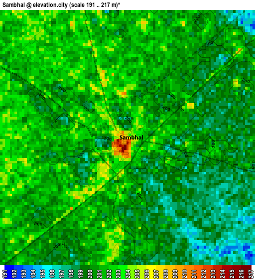
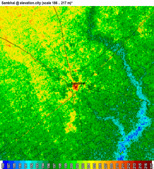
Below is the Elevation map of Sambhal, which displays elevation range with different colors. Scale of the first map is from 191 to 217 m (627 to 712 ft) with average elevation of 200.3 meters (=657 ft) [note 1]
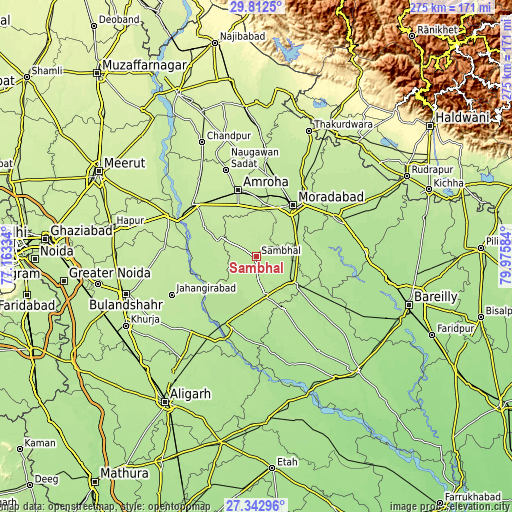
These maps also provides idea of topography and contour of this city, they are displayed at different zoom levels. More info about maps, scale and edge coordinates you can find below images.
| \ | Map #1 | Map #2 | Topo.Map |
| Scale [m] | 191..217 m | 186..217 m | × |
| Scale [ft] | 627..712 ft | 610..712 ft | × |
| Average | 200.3 m = 657 ft | 199.5 m = 655 ft | × |
| Width | 8.58 km = 5.3 mi | 17.16 km = 10.7 mi | 274.6 km = 170.6 mi |
| Height | 8.58 km = 5.3 mi | 17.16 km = 10.7 mi | 274.6 km = 170.6 mi |
| ↑Max Latitude | 28.623562° | 28.662129° | 29.8125° |
| Latitude at center | 28.58498° | 28.58498° | 28.58498° |
| ↓Min Latitude | 28.546384° | 28.507774° | 27.34296° |
| ← Min Longitude | 78.525645° | 78.481699° | 77.16334° |
| Longitude center | 78.56959° | 78.56959° | 78.56959° |
| →Max Longitude | 78.613535° | 78.657481° | 79.97584° |
Nearby cities:
Cities around Sambhal sort by population:
• Morādābād elevation 205 m
34.7 km,  35°
35°
• Amroha 218 m
36.7 km,  344°
344°
• Chanduasi 193 m
25.6 km,  125°
125°
• Hasanpur 211 m
31.8 km,  298°
298°
• Bahjoi 193 m
21.8 km,  165°
165°
• Bilāri 198 m
23.2 km,  79°
79°
• Islāmnagar 190 m
32.3 km,  151°
151°
• Kundarkhi 198 m
23.7 km,  62°
62°
• Anūpshahr 197 m
38.8 km,  229°
229°
• Sirsi 202 m
9.4 km,  49°
49°
• Narauli 195 m
18 km, 127°
• Gawān 191 m
28.1 km, 229°
Multilingual:
 En español:
Sambhal elevación 203 m.
 En France:
Sambhal élévation 203 m.


Sources and notes:
- [note 1] Map square and city borders are not equal. Map elevation data is calculated only from area inside that square.
- [src 1] Elevation data from geonames database provided with same terms of usage.
- [src 2] The elevation map of Sambhal is generated using elevation data from NASA's 3 arcsec (90m) resolution SRTM data.
- [src 3] Base (background) map © OpenStreetMap contributors tiles are generated by Geofabrik and OpenTopoMap.
Copyright & License:
This Sambhal Elevation Map is licensed under CC BY-SA. You may reuse any part from this page, if you give a proper credit by linking to this URL:
 More info on terms of use page.