Pokaran elevation
Pokaran (Rajasthan, Jaisalmer), India elevation is 233 meters and Pokaran elevation in feet is 764 ft above sea level [src 1]. Pokaran is a populated place (feature code) with elevation that is 60 meters (197 ft) smaller than average city elevation in India.
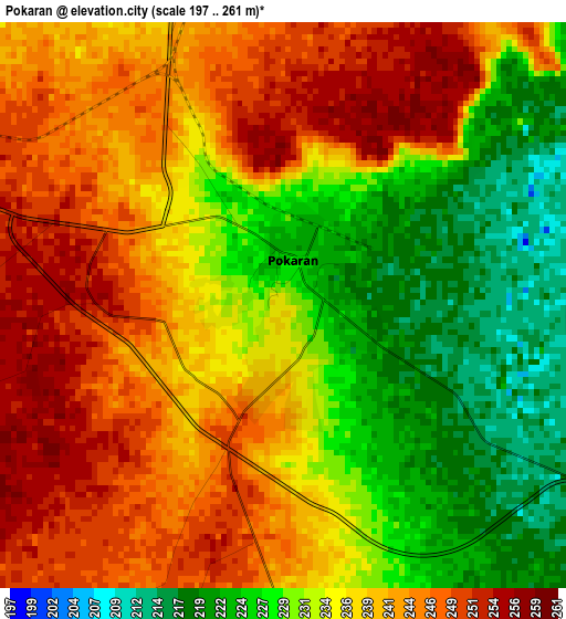
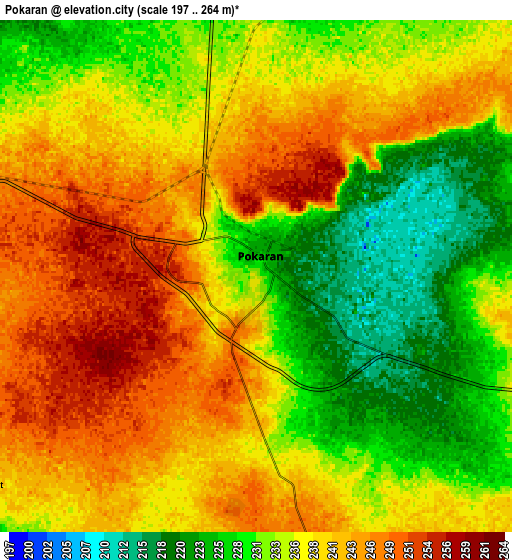
Below is the Elevation map of Pokaran, which displays elevation range with different colors. Scale of the first map is from 197 to 261 m (646 to 856 ft) with average elevation of 236.4 meters (=776 ft) [note 1]
These maps also provides idea of topography and contour of this city, they are displayed at different zoom levels. More info about maps, scale and edge coordinates you can find below images.
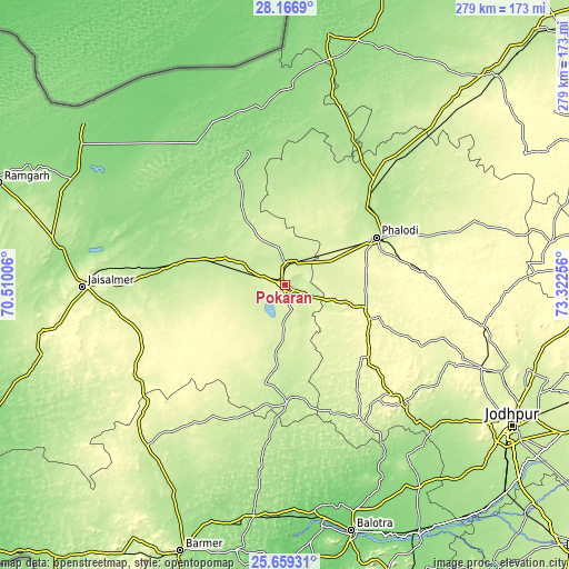
| \ | Map #1 | Map #2 | Topo.Map |
| Scale [m] | 197..261 m | 197..264 m | × |
| Scale [ft] | 646..856 ft | 646..866 ft | × |
| Average | 236.4 m = 776 ft | 236.7 m = 777 ft | × |
| Width | 8.71 km = 5.4 mi | 17.43 km = 10.8 mi | 278.8 km = 173.2 mi |
| Height | 8.71 km = 5.4 mi | 17.43 km = 10.8 mi | 278.8 km = 173.2 mi |
| ↑Max Latitude | 26.959247° | 26.998409° | 28.1669° |
| Latitude at center | 26.92007° | 26.92007° | 26.92007° |
| ↓Min Latitude | 26.88088° | 26.841676° | 25.65931° |
| ← Min Longitude | 71.872365° | 71.828419° | 70.51006° |
| Longitude center | 71.91631° | 71.91631° | 71.91631° |
| →Max Longitude | 71.960255° | 72.004201° | 73.32256° |
Nearby cities:
Cities around Pokaran sort by population:
• Jodhpur elevation 237 m
130.3 km,  123°
123°
• Nāgaur 305 m
182.7 km,  80°
80°
• Bārmer 202 m
140.6 km,  201°
201°
• Bālotra 115 m
125.2 km,  165°
165°
• Jaisalmer 234 m
100.4 km,  269°
269°
• Nokha 320 m
169.5 km,  65°
65°
• Phalodi 228 m
50.5 km,  62°
62°
• Pīpār 259 m
172.4 km,  110°
110°
• Basni 306 m
173.5 km, 80°
• Siwāna 188 m
149.8 km,  160°
160°
• Samdari 143 m
139.7 km,  151°
151°
• Deshnoke 275 m
171.4 km, 55°
Multilingual:
 En español:
Pokaran elevación 233 m.
 En France:
Pokaran élévation 233 m.


Sources and notes:
- [note 1] Map square and city borders are not equal. Map elevation data is calculated only from area inside that square.
- [src 1] Elevation data from geonames database provided with same terms of usage.
- [src 2] The elevation map of Pokaran is generated using elevation data from NASA's 3 arcsec (90m) resolution SRTM data.
- [src 3] Base (background) map © OpenStreetMap contributors tiles are generated by Geofabrik and OpenTopoMap.
Copyright & License:
This Pokaran Elevation Map is licensed under CC BY-SA. You may reuse any part from this page, if you give a proper credit by linking to this URL:
 More info on terms of use page.