Bārmer elevation
Bārmer (Rajasthan), India elevation is 202 meters and Bārmer elevation in feet is 663 ft above sea level [src 1]. Bārmer is a populated place (feature code) with elevation that is 91 meters (299 ft) smaller than average city elevation in India.
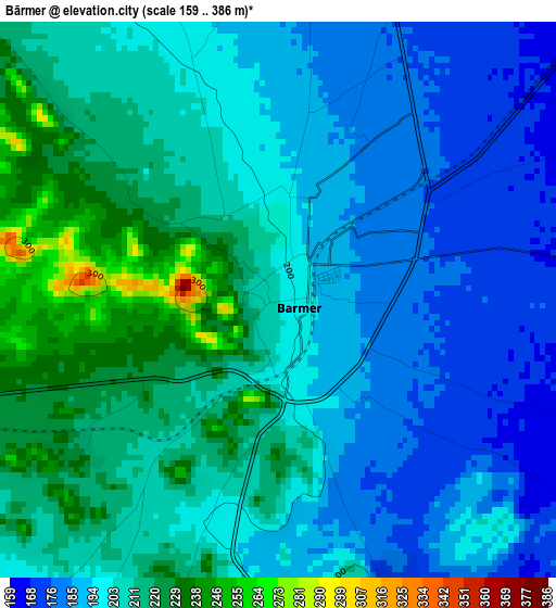
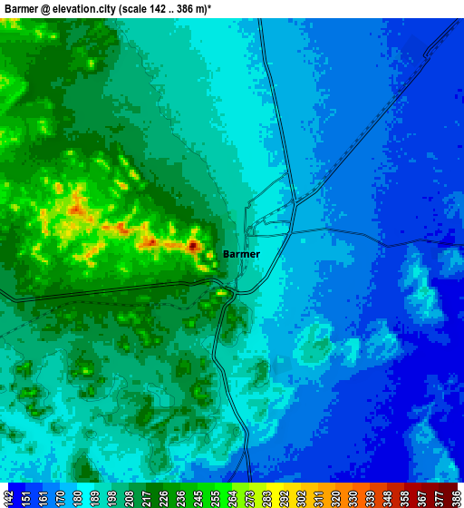
Below is the Elevation map of Bārmer, which displays elevation range with different colors. Scale of the first map is from 159 to 386 m (522 to 1266 ft) with average elevation of 202 meters (=663 ft) [note 1]
These maps also provides idea of topography and contour of this city, they are displayed at different zoom levels. More info about maps, scale and edge coordinates you can find below images.
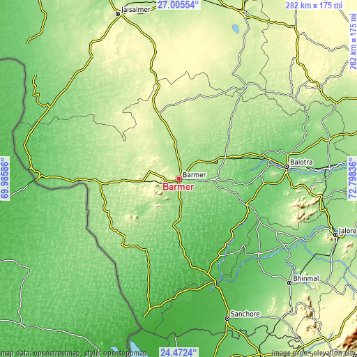
| \ | Map #1 | Map #2 | Topo.Map |
| Scale [m] | 159..386 m | 142..386 m | × |
| Scale [ft] | 522..1266 ft | 466..1266 ft | × |
| Average | 202 m = 663 ft | 191.8 m = 629 ft | × |
| Width | 8.8 km = 5.5 mi | 17.6 km = 10.9 mi | 281.7 km = 175 mi |
| Height | 8.8 km = 5.5 mi | 17.6 km = 10.9 mi | 281.7 km = 175 mi |
| ↑Max Latitude | 25.785296° | 25.824859° | 27.00554° |
| Latitude at center | 25.74572° | 25.74572° | 25.74572° |
| ↓Min Latitude | 25.706131° | 25.666528° | 24.4724° |
| ← Min Longitude | 71.348165° | 71.304219° | 69.98586° |
| Longitude center | 71.39211° | 71.39211° | 71.39211° |
| →Max Longitude | 71.436055° | 71.480001° | 72.79836° |
Nearby cities:
Cities around Bārmer sort by population:
• Jodhpur elevation 237 m
171.4 km,  70°
70°
• Bālotra 115 m
85.4 km,  83°
83°
• Jaisalmer 234 m
139.1 km,  339°
339°
• Jalor 172 m
130.6 km,  109°
109°
• Bhīnmāl 153 m
121.2 km,  133°
133°
• Sānchor 62 m
116.8 km,  160°
160°
• Tharād 53 m
151.9 km,  171°
171°
• Dhanera 137 m
151.4 km, 155°
• Siwāna 188 m
103.8 km,  95°
95°
• Pokaran 233 m
140.6 km,  21°
21°
• Samdari 143 m
119 km,  86°
86°
• Takhatgarh 224 m
168.5 km, 106°
Multilingual:
 En español:
Bārmer elevación 202 m.
 En France:
Bārmer élévation 202 m.


Sources and notes:
- [note 1] Map square and city borders are not equal. Map elevation data is calculated only from area inside that square.
- [src 1] Elevation data from geonames database provided with same terms of usage.
- [src 2] The elevation map of Bārmer is generated using elevation data from NASA's 3 arcsec (90m) resolution SRTM data.
- [src 3] Base (background) map © OpenStreetMap contributors tiles are generated by Geofabrik and OpenTopoMap.
Copyright & License:
This Bārmer Elevation Map is licensed under CC BY-SA. You may reuse any part from this page, if you give a proper credit by linking to this URL:
 More info on terms of use page.