Jaisalmer elevation
Jaisalmer (Rajasthan), India elevation is 234 meters and Jaisalmer elevation in feet is 768 ft above sea level [src 1]. Jaisalmer is a populated place (feature code) with elevation that is 59 meters (194 ft) smaller than average city elevation in India.
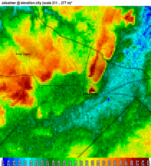
Below is the Elevation map of Jaisalmer, which displays elevation range with different colors. Scale of the first map is from 211 to 277 m (692 to 909 ft) with average elevation of 241 meters (=791 ft) [note 1]
These maps also provides idea of topography and contour of this city, they are displayed at different zoom levels. More info about maps, scale and edge coordinates you can find below images.
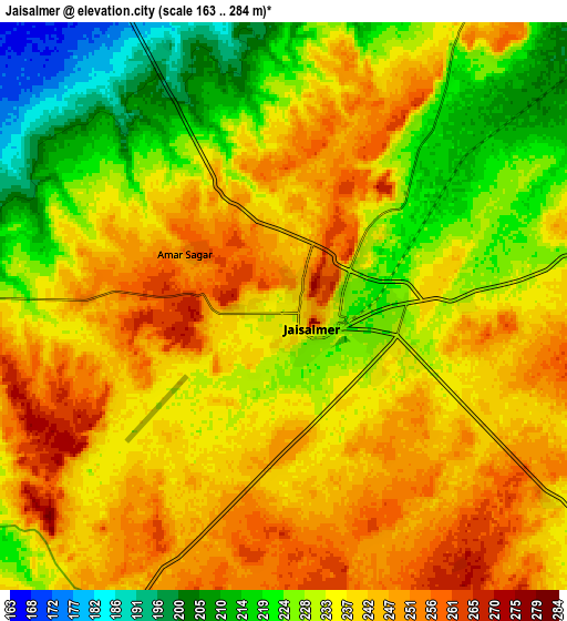
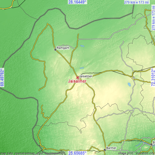
| \ | Map #1 | Map #2 | Topo.Map |
| Scale [m] | 211..277 m | 163..284 m | × |
| Scale [ft] | 692..909 ft | 535..932 ft | × |
| Average | 241 m = 791 ft | 235.7 m = 773 ft | × |
| Width | 8.71 km = 5.4 mi | 17.43 km = 10.8 mi | 278.8 km = 173.2 mi |
| Height | 8.71 km = 5.4 mi | 17.43 km = 10.8 mi | 278.8 km = 173.2 mi |
| ↑Max Latitude | 26.956807° | 26.995971° | 28.16449° |
| Latitude at center | 26.91763° | 26.91763° | 26.91763° |
| ↓Min Latitude | 26.878439° | 26.839234° | 25.65685° |
| ← Min Longitude | 70.859925° | 70.815979° | 69.49762° |
| Longitude center | 70.90387° | 70.90387° | 70.90387° |
| →Max Longitude | 70.947815° | 70.991761° | 72.31012° |
Nearby cities:
Cities around Jaisalmer sort by population:
• Jodhpur elevation 237 m
221.1 km,  109°
109°
• Bārmer 202 m
139.1 km,  159°
159°
• Bālotra 115 m
179.6 km,  132°
132°
• Nokha 320 m
263.7 km,  74°
74°
• Jalor 172 m
244.4 km,  135°
135°
• Phalodi 228 m
147 km,  80°
80°
• Bhīnmāl 153 m
253.3 km,  147°
147°
• Sānchor 62 m
255.8 km, 160°
• Siwāna 188 m
206.7 km, 132°
• Pokaran 233 m
100.4 km,  89°
89°
• Samdari 143 m
207.2 km, 126°
• Deshnoke 275 m
260 km, 67°
Multilingual:
 En español:
Jaisalmer elevación 234 m.
 En France:
Jaisalmer élévation 234 m.
 Auf Deutsch:
Jaisalmer höhe über dem Meeresspiegel ist 234 m.

Sources and notes:
- [note 1] Map square and city borders are not equal. Map elevation data is calculated only from area inside that square.
- [src 1] Elevation data from geonames database provided with same terms of usage.
- [src 2] The elevation map of Jaisalmer is generated using elevation data from NASA's 3 arcsec (90m) resolution SRTM data.
- [src 3] Base (background) map © OpenStreetMap contributors tiles are generated by Geofabrik and OpenTopoMap.
Copyright & License:
This Jaisalmer Elevation Map is licensed under CC BY-SA. You may reuse any part from this page, if you give a proper credit by linking to this URL:
 More info on terms of use page.