Nāgaur elevation
Nāgaur (Rajasthan), India elevation is 305 meters and Nāgaur elevation in feet is 1001 ft above sea level [src 1]. Nāgaur is a populated place (feature code) with elevation that is 12 meters (39 ft) bigger than average city elevation in India.
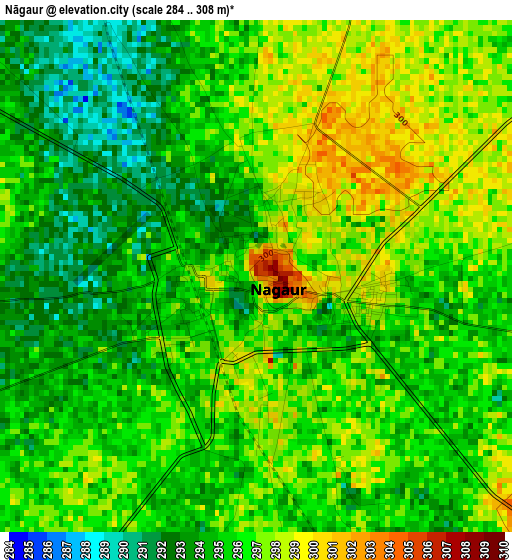
Below is the Elevation map of Nāgaur, which displays elevation range with different colors. Scale of the first map is from 284 to 308 m (932 to 1010 ft) with average elevation of 295.4 meters (=969 ft) [note 1]
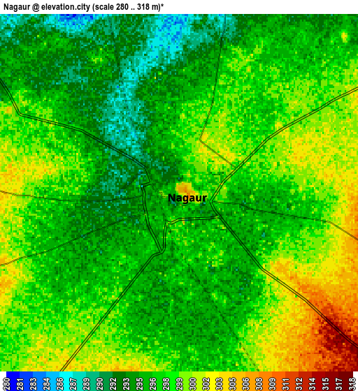
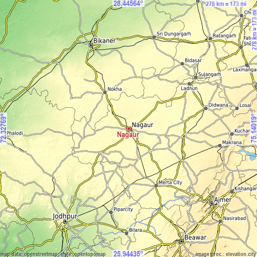
These maps also provides idea of topography and contour of this city, they are displayed at different zoom levels. More info about maps, scale and edge coordinates you can find below images.
| \ | Map #1 | Map #2 | Topo.Map |
| Scale [m] | 284..308 m | 280..318 m | × |
| Scale [ft] | 932..1010 ft | 919..1043 ft | × |
| Average | 295.4 m = 969 ft | 297.1 m = 975 ft | × |
| Width | 8.69 km = 5.4 mi | 17.38 km = 10.8 mi | 278.1 km = 172.8 mi |
| Height | 8.69 km = 5.4 mi | 17.38 km = 10.8 mi | 278.1 km = 172.8 mi |
| ↑Max Latitude | 27.241088° | 27.280153° | 28.44564° |
| Latitude at center | 27.20201° | 27.20201° | 27.20201° |
| ↓Min Latitude | 27.162918° | 27.123813° | 25.94435° |
| ← Min Longitude | 73.689995° | 73.646049° | 72.32769° |
| Longitude center | 73.73394° | 73.73394° | 73.73394° |
| →Max Longitude | 73.777885° | 73.821831° | 75.14019° |
Nearby cities:
Cities around Nāgaur sort by population:
• Sūjāngarh elevation 319 m
91.1 km,  52°
52°
• Lādnūn 322 m
82.7 km, 52°
• Nokha 320 m
47.6 km,  327°
327°
• Dīdwāna 348 m
86 km,  75°
75°
• Merta 324 m
68.4 km,  154°
154°
• Pīpār 259 m
92.8 km,  191°
191°
• Basni 306 m
9.4 km,  249°
249°
• Kuchera 317 m
33.5 km,  135°
135°
• Napāsar 248 m
86.1 km,  348°
348°
• Chhāpar 311 m
97.7 km, 45°
• Mūndwa 348 m
17.8 km, 150°
• Deshnoke 275 m
76.7 km, 329°
Multilingual:
 En español:
Nāgaur elevación 305 m.
 En France:
Nāgaur élévation 305 m.


Sources and notes:
- [note 1] Map square and city borders are not equal. Map elevation data is calculated only from area inside that square.
- [src 1] Elevation data from geonames database provided with same terms of usage.
- [src 2] The elevation map of Nāgaur is generated using elevation data from NASA's 3 arcsec (90m) resolution SRTM data.
- [src 3] Base (background) map © OpenStreetMap contributors tiles are generated by Geofabrik and OpenTopoMap.
Copyright & License:
This Nāgaur Elevation Map is licensed under CC BY-SA. You may reuse any part from this page, if you give a proper credit by linking to this URL:
 More info on terms of use page.