Rengāli elevation
Rengāli (Odisha, Sambalpur), India elevation is 216 meters and Rengāli elevation in feet is 709 ft above sea level [src 1]. Rengāli is a populated place (feature code) with elevation that is 77 meters (253 ft) smaller than average city elevation in India.
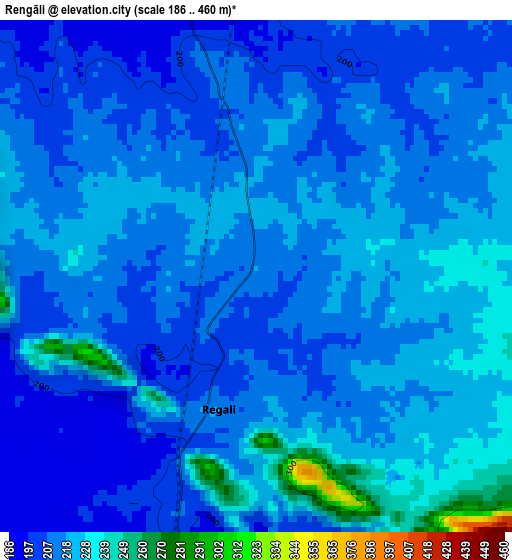
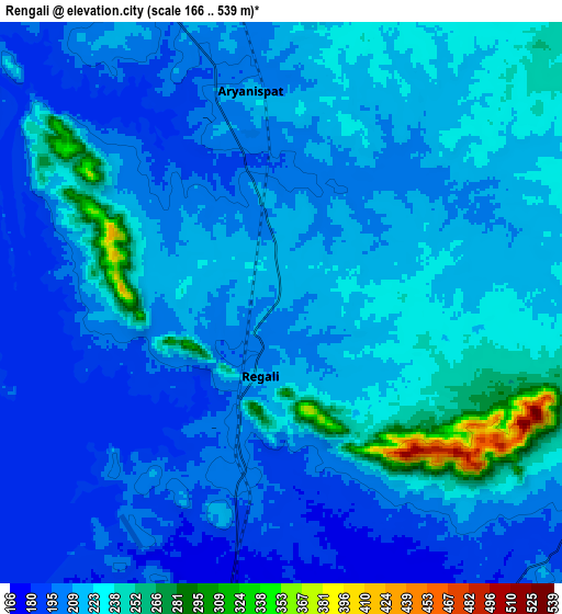
Below is the Elevation map of Rengāli, which displays elevation range with different colors. Scale of the first map is from 186 to 460 m (610 to 1509 ft) with average elevation of 215.3 meters (=706 ft) [note 1]
These maps also provides idea of topography and contour of this city, they are displayed at different zoom levels. More info about maps, scale and edge coordinates you can find below images.
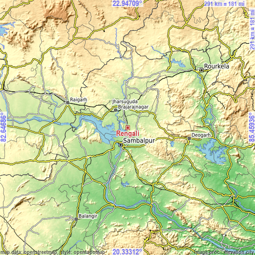
| \ | Map #1 | Map #2 | Topo.Map |
| Scale [m] | 186..460 m | 166..539 m | × |
| Scale [ft] | 610..1509 ft | 545..1768 ft | × |
| Average | 215.3 m = 706 ft | 215.4 m = 707 ft | × |
| Width | 9.08 km = 5.6 mi | 18.17 km = 11.3 mi | 290.6 km = 180.6 mi |
| Height | 9.08 km = 5.6 mi | 18.17 km = 11.3 mi | 290.7 km = 180.6 mi |
| ↑Max Latitude | 21.686861° | 21.727689° | 22.94709° |
| Latitude at center | 21.64602° | 21.64602° | 21.64602° |
| ↓Min Latitude | 21.605168° | 21.564304° | 20.33312° |
| ← Min Longitude | 84.009165° | 83.965219° | 82.64686° |
| Longitude center | 84.05311° | 84.05311° | 84.05311° |
| →Max Longitude | 84.097055° | 84.141001° | 85.45936° |
Nearby cities:
Cities around Rengāli sort by population:
• Sambalpur elevation 152 m
21.6 km,  201°
201°
• Raigarh 224 m
73.3 km,  292°
292°
• Jharsuguda 219 m
23.8 km,  348°
348°
• Brājarājnagar 219 m
23.6 km,  323°
323°
• Bargarh 179 m
56.8 km,  232°
232°
• Sundargarh 239 m
52.4 km,  357°
357°
• Burla 167 m
24 km, 230°
• Hīrākud 168 m
23 km, 234°
• Deogarh 220 m
71.3 km,  99°
99°
• Barpāli 182 m
70 km,  223°
223°
• Binka 126 m
73.3 km, 199°
• Kuchinda 243 m
32.4 km,  70°
70°
Multilingual:
 En español:
Rengāli elevación 216 m.
 En France:
Rengāli élévation 216 m.


Sources and notes:
- [note 1] Map square and city borders are not equal. Map elevation data is calculated only from area inside that square.
- [src 1] Elevation data from geonames database provided with same terms of usage.
- [src 2] The elevation map of Rengāli is generated using elevation data from NASA's 3 arcsec (90m) resolution SRTM data.
- [src 3] Base (background) map © OpenStreetMap contributors tiles are generated by Geofabrik and OpenTopoMap.
Copyright & License:
This Rengāli Elevation Map is licensed under CC BY-SA. You may reuse any part from this page, if you give a proper credit by linking to this URL:
 More info on terms of use page.