Deogarh elevation
Deogarh (Odisha, Debagarh), India elevation is 220 meters and Deogarh elevation in feet is 722 ft above sea level [src 1]. Deogarh is a populated place (feature code) with elevation that is 73 meters (240 ft) smaller than average city elevation in India.
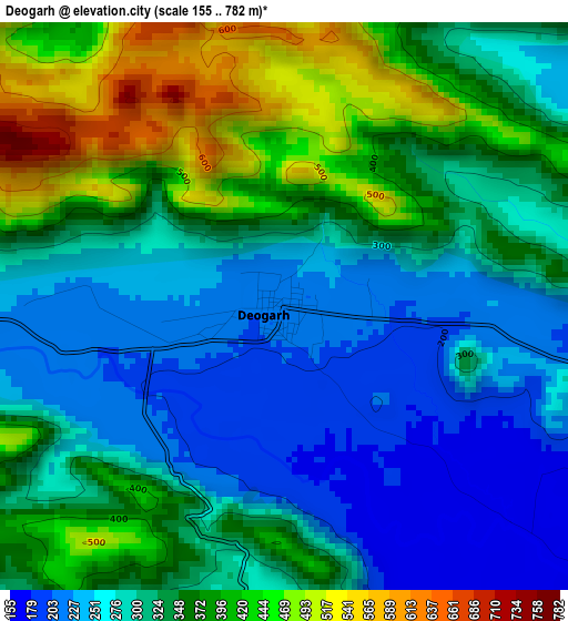
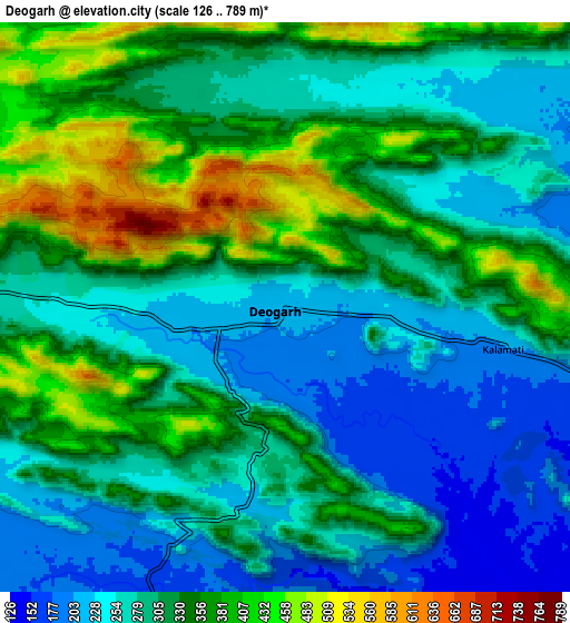
Below is the Elevation map of Deogarh, which displays elevation range with different colors. Scale of the first map is from 155 to 782 m (509 to 2566 ft) with average elevation of 326.8 meters (=1072 ft) [note 1]
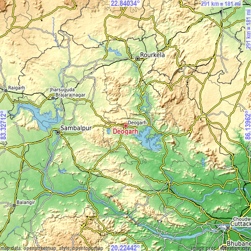
These maps also provides idea of topography and contour of this city, they are displayed at different zoom levels. More info about maps, scale and edge coordinates you can find below images.
| \ | Map #1 | Map #2 | Topo.Map |
| Scale [m] | 155..782 m | 126..789 m | × |
| Scale [ft] | 509..2566 ft | 413..2589 ft | × |
| Average | 326.8 m = 1072 ft | 309.7 m = 1016 ft | × |
| Width | 9.09 km = 5.6 mi | 18.18 km = 11.3 mi | 290.9 km = 180.8 mi |
| Height | 9.09 km = 5.6 mi | 18.18 km = 11.3 mi | 290.9 km = 180.8 mi |
| ↑Max Latitude | 21.579141° | 21.62° | 22.84034° |
| Latitude at center | 21.53827° | 21.53827° | 21.53827° |
| ↓Min Latitude | 21.497388° | 21.456494° | 20.22442° |
| ← Min Longitude | 84.689425° | 84.645479° | 83.32712° |
| Longitude center | 84.73337° | 84.73337° | 84.73337° |
| →Max Longitude | 84.777315° | 84.821261° | 86.13962° |
Nearby cities:
Cities around Deogarh sort by population:
• Raurkela elevation 195 m
77.5 km,  10°
10°
• Sambalpur 152 m
78.8 km,  264°
264°
• Jharsuguda 219 m
82.9 km,  295°
295°
• Angul 126 m
86.4 km,  153°
153°
• Burla 167 m
89.1 km,  267°
267°
• Tālcher 80 m
83.5 km,  141°
141°
• Hīrākud 168 m
89 km, 269°
• Baud 96 m
88.6 km,  208°
208°
• Kuchinda 243 m
45.9 km, 299°
• Bānposh 199 m
79.4 km, 5°
• Kiri Buru 466 m
87.9 km,  46°
46°
• Rengāli 216 m
71.3 km,  279°
279°
Multilingual:
 En español:
Deogarh elevación 220 m.
 En France:
Deogarh élévation 220 m.


Sources and notes:
- [note 1] Map square and city borders are not equal. Map elevation data is calculated only from area inside that square.
- [src 1] Elevation data from geonames database provided with same terms of usage.
- [src 2] The elevation map of Deogarh is generated using elevation data from NASA's 3 arcsec (90m) resolution SRTM data.
- [src 3] Base (background) map © OpenStreetMap contributors tiles are generated by Geofabrik and OpenTopoMap.
Copyright & License:
This Deogarh Elevation Map is licensed under CC BY-SA. You may reuse any part from this page, if you give a proper credit by linking to this URL:
 More info on terms of use page.