Binka elevation
Binka (Odisha, Subarnapur), India elevation is 126 meters and Binka elevation in feet is 413 ft above sea level [src 1]. Binka is a populated place (feature code) with elevation that is 167 meters (548 ft) smaller than average city elevation in India.
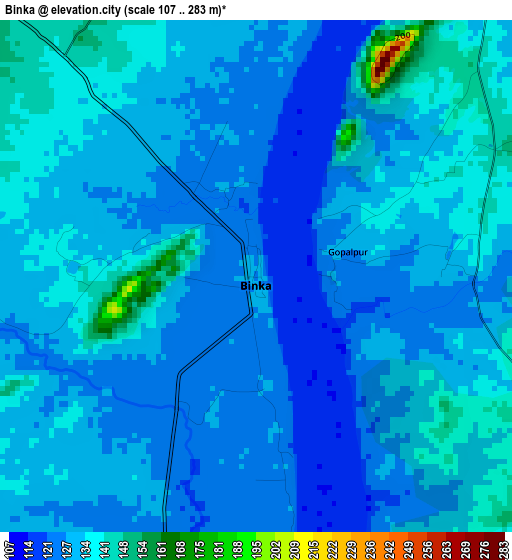
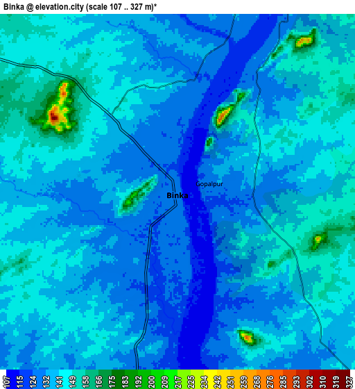
Below is the Elevation map of Binka, which displays elevation range with different colors. Scale of the first map is from 107 to 283 m (351 to 928 ft) with average elevation of 130.2 meters (=427 ft) [note 1]
These maps also provides idea of topography and contour of this city, they are displayed at different zoom levels. More info about maps, scale and edge coordinates you can find below images.
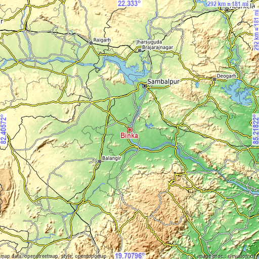
| \ | Map #1 | Map #2 | Topo.Map |
| Scale [m] | 107..283 m | 107..327 m | × |
| Scale [ft] | 351..928 ft | 351..1073 ft | × |
| Average | 130.2 m = 427 ft | 137.4 m = 451 ft | × |
| Width | 9.12 km = 5.7 mi | 18.24 km = 11.3 mi | 291.9 km = 181.4 mi |
| Height | 9.12 km = 5.7 mi | 18.24 km = 11.3 mi | 291.9 km = 181.4 mi |
| ↑Max Latitude | 21.067274° | 21.108276° | 22.333° |
| Latitude at center | 21.02626° | 21.02626° | 21.02626° |
| ↓Min Latitude | 20.985235° | 20.944199° | 19.70796° |
| ← Min Longitude | 83.768025° | 83.724079° | 82.40572° |
| Longitude center | 83.81197° | 83.81197° | 83.81197° |
| →Max Longitude | 83.855915° | 83.899861° | 85.21822° |
Nearby cities:
Cities around Binka sort by population:
• Sambalpur elevation 152 m
51.7 km,  19°
19°
• Balāngīr 187 m
49 km,  223°
223°
• Bargarh 179 m
39.6 km,  329°
329°
• Burla 167 m
54.1 km,  6°
6°
• Phulbāni 482 m
74.6 km,  144°
144°
• Hīrākud 168 m
55.8 km, 6°
• Barpāli 182 m
29.6 km,  307°
307°
• Baud 96 m
57.4 km,  111°
111°
• Sonepur 105 m
24.1 km,  153°
153°
• Padampur 200 m
77.8 km,  267°
267°
• Tarabha 134 m
35.6 km,  203°
203°
• Rengāli 216 m
73.3 km, 19°
Multilingual:
 En español:
Binka elevación 126 m.
 En France:
Binka élévation 126 m.


Sources and notes:
- [note 1] Map square and city borders are not equal. Map elevation data is calculated only from area inside that square.
- [src 1] Elevation data from geonames database provided with same terms of usage.
- [src 2] The elevation map of Binka is generated using elevation data from NASA's 3 arcsec (90m) resolution SRTM data.
- [src 3] Base (background) map © OpenStreetMap contributors tiles are generated by Geofabrik and OpenTopoMap.
Copyright & License:
This Binka Elevation Map is licensed under CC BY-SA. You may reuse any part from this page, if you give a proper credit by linking to this URL:
 More info on terms of use page.