Bandung elevation
Bandung (West Java), Indonesia elevation is 714 meters and Bandung elevation in feet is 2343 ft above sea level [src 1]. Bandung is a seat of a first-order administrative division (feature code) with elevation that is 523 meters (1716 ft) bigger than average city elevation in Indonesia.
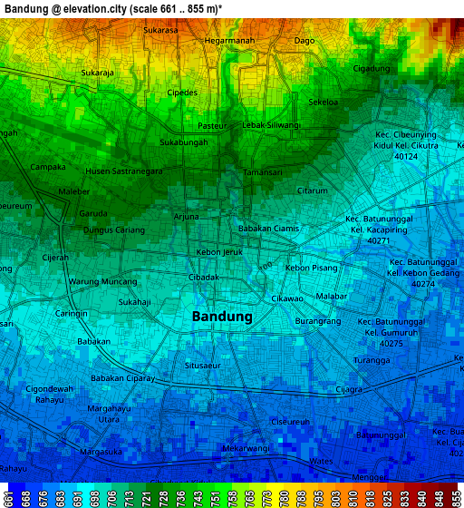
Below is the Elevation map of Bandung, which displays elevation range with different colors. Scale of the first map is from 661 to 855 m (2169 to 2805 ft) with average elevation of 711.6 meters (=2335 ft) [note 1]
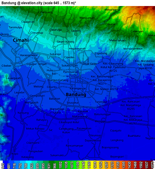
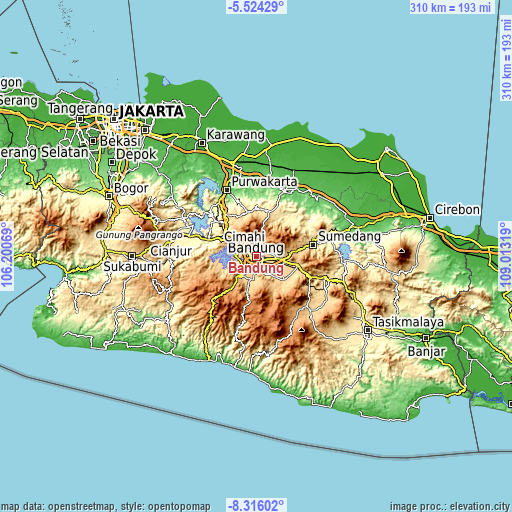
These maps also provides idea of topography and contour of this city, they are displayed at different zoom levels. More info about maps, scale and edge coordinates you can find below images.
| \ | Map #1 | Map #2 | Topo.Map |
| Scale [m] | 661..855 m | 645..1573 m | × |
| Scale [ft] | 2169..2805 ft | 2116..5161 ft | × |
| Average | 711.6 m = 2335 ft | 759.9 m = 2493 ft | × |
| Width | 9.7 km = 6 mi | 19.4 km = 12.1 mi | 310.4 km = 192.9 mi |
| Height | 9.7 km = 6 mi | 19.4 km = 12.1 mi | 310.4 km = 192.9 mi |
| ↑Max Latitude | -6.878593° | -6.834962° | -5.52429° |
| Latitude at center | -6.92222° | -6.92222° | -6.92222° |
| ↓Min Latitude | -6.965843° | -7.009462° | -8.31602° |
| ← Min Longitude | 107.562995° | 107.519049° | 106.20069° |
| Longitude center | 107.60694° | 107.60694° | 107.60694° |
| →Max Longitude | 107.650885° | 107.694831° | 109.01319° |
Nearby cities:
Cities around Bandung sort by population:
• Cimahi elevation 764 m
9 km,  308°
308°
• Sumedang 460 m
34.9 km,  78°
78°
• Lembang 1252 m
12.3 km,  5°
5°
• Banjaran 674 m
13.8 km,  188°
188°
• Soreang 744 m
15.7 km,  218°
218°
• Paseh 918 m
26.5 km,  139°
139°
• Padalarang 703 m
17.5 km,  302°
302°
• Cileunyi 703 m
16.2 km,  96°
96°
• Sumedang Utara 467 m
35.1 km, 76°
• Margahayukencana 668 m
6.9 km, 218°
• Pameungpeuk 665 m
10.7 km,  181°
181°
• Banjar 1874 m
36 km,  212°
212°
Multilingual:
 En español:
Bandung elevación 714 m.
 En France:
Bandung élévation 714 m.


Sources and notes:
- [note 1] Map square and city borders are not equal. Map elevation data is calculated only from area inside that square.
- [src 1] Elevation data from geonames database provided with same terms of usage.
- [src 2] The elevation map of Bandung is generated using elevation data from NASA's 3 arcsec (90m) resolution SRTM data.
- [src 3] Base (background) map © OpenStreetMap contributors tiles are generated by Geofabrik and OpenTopoMap.
Copyright & License:
This Bandung Elevation Map is licensed under CC BY-SA. You may reuse any part from this page, if you give a proper credit by linking to this URL:
 More info on terms of use page.