Paseh elevation
Paseh (West Java), Indonesia elevation is 918 meters and Paseh elevation in feet is 3012 ft above sea level [src 1]. Paseh is a populated place (feature code) with elevation that is 727 meters (2385 ft) bigger than average city elevation in Indonesia.
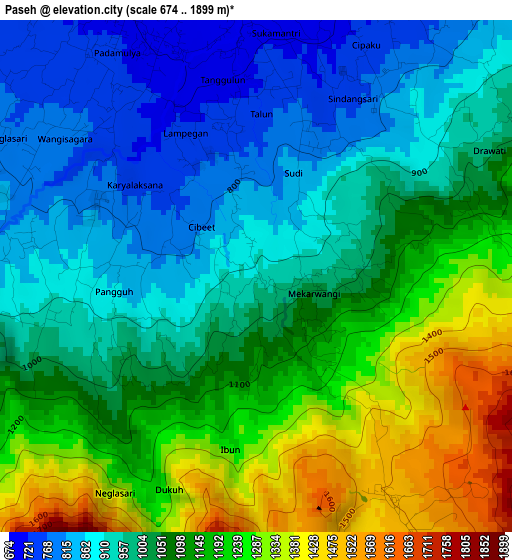
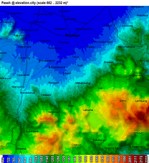
Below is the Elevation map of Paseh, which displays elevation range with different colors. Scale of the first map is from 674 to 1899 m (2211 to 6230 ft) with average elevation of 1059.4 meters (=3476 ft) [note 1]
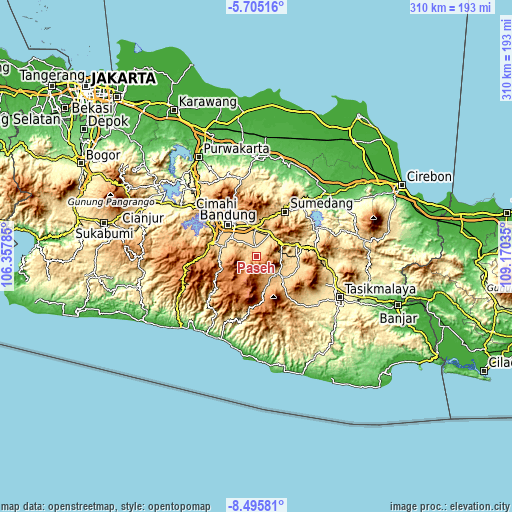
These maps also provides idea of topography and contour of this city, they are displayed at different zoom levels. More info about maps, scale and edge coordinates you can find below images.
| \ | Map #1 | Map #2 | Topo.Map |
| Scale [m] | 674..1899 m | 662..2232 m | × |
| Scale [ft] | 2211..6230 ft | 2172..7323 ft | × |
| Average | 1059.4 m = 3476 ft | 1107.1 m = 3632 ft | × |
| Width | 9.7 km = 6 mi | 19.4 km = 12.1 mi | 310.3 km = 192.8 mi |
| Height | 9.7 km = 6 mi | 19.4 km = 12.1 mi | 310.3 km = 192.8 mi |
| ↑Max Latitude | -7.05899° | -7.015376° | -5.70516° |
| Latitude at center | -7.1026° | -7.1026° | -7.1026° |
| ↓Min Latitude | -7.146206° | -7.189808° | -8.49581° |
| ← Min Longitude | 107.720155° | 107.676209° | 106.35785° |
| Longitude center | 107.7641° | 107.7641° | 107.7641° |
| →Max Longitude | 107.808045° | 107.851991° | 109.17035° |
Nearby cities:
Cities around Paseh sort by population:
• Banjaran elevation 674 m
20.5 km,  288°
288°
• Cileunyi 703 m
18.2 km,  356°
356°
• Pameungpeuk 665 m
20 km,  297°
297°
• Bunisari 594 m
22 km,  81°
81°
• Banyuresmi 700 m
21.7 km,  107°
107°
• Pasirluhur 620 m
21 km,  90°
90°
• Pakuwon 720 m
19.9 km,  129°
129°
• Bayongbong 975 m
19.8 km,  161°
161°
• Garut 756 m
17.6 km, 129°
• Tarogong 743 m
16.7 km, 125°
• Leles 717 m
14.9 km, 93°
• Sukasari 710 m
14.7 km, 78°
Multilingual:
 En español:
Paseh elevación 918 m.
 En France:
Paseh élévation 918 m.


Sources and notes:
- [note 1] Map square and city borders are not equal. Map elevation data is calculated only from area inside that square.
- [src 1] Elevation data from geonames database provided with same terms of usage.
- [src 2] The elevation map of Paseh is generated using elevation data from NASA's 3 arcsec (90m) resolution SRTM data.
- [src 3] Base (background) map © OpenStreetMap contributors tiles are generated by Geofabrik and OpenTopoMap.
Copyright & License:
This Paseh Elevation Map is licensed under CC BY-SA. You may reuse any part from this page, if you give a proper credit by linking to this URL:
 More info on terms of use page.