Bayongbong elevation
Bayongbong (West Java), Indonesia elevation is 975 meters and Bayongbong elevation in feet is 3199 ft above sea level [src 1]. Bayongbong is a seat of a third-order administrative division (feature code) with elevation that is 784 meters (2572 ft) bigger than average city elevation in Indonesia.
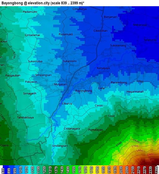
Below is the Elevation map of Bayongbong, which displays elevation range with different colors. Scale of the first map is from 839 to 2399 m (2753 to 7871 ft) with average elevation of 1139 meters (=3737 ft) [note 1]
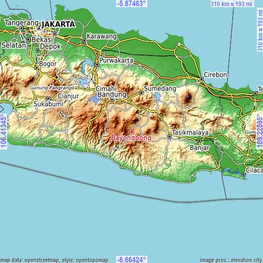
These maps also provides idea of topography and contour of this city, they are displayed at different zoom levels. More info about maps, scale and edge coordinates you can find below images.
| \ | Map #1 | Topo.Map |
| Scale [m] | 839..2399 m | × |
| Scale [ft] | 2753..7871 ft | × |
| Average | 1139 m = 3737 ft | × |
| Width | 9.69 km = 6 mi | 310.2 km = 192.7 mi |
| Height | 9.69 km = 6 mi | 310.2 km = 192.7 mi |
| ↑Max Latitude | -7.228006° | -5.87463° |
| Latitude at center | -7.2716° | -7.2716° |
| ↓Min Latitude | -7.31519° | -8.66424° |
| ← Min Longitude | 107.775755° | 106.41345° |
| Longitude center | 107.8197° | 107.8197° |
| →Max Longitude | 107.863645° | 109.22595° |
Nearby cities:
Cities around Bayongbong sort by population:
• Paseh elevation 918 m
19.8 km,  341°
341°
• Wanaraja 724 m
20.8 km,  58°
58°
• Banjarwangi 675 m
20.8 km,  153°
153°
• Leles 717 m
20 km,  25°
25°
• Banyuresmi 700 m
19.1 km,  49°
49°
• Karangpawitan 752 m
15.7 km, 62°
• Tarogong 743 m
11.7 km,  39°
39°
• Pakuwon 720 m
11.2 km, 56°
• Cilawu 969 m
11.1 km,  93°
93°
• Garut 756 m
10.8 km, 44°
• Cikajang 1253 m
9.7 km,  187°
187°
• Gudang 1215 m
4.7 km,  212°
212°
Multilingual:
 En español:
Bayongbong elevación 975 m.
 En France:
Bayongbong élévation 975 m.
 Auf Deutsch:
Bayongbong höhe über dem Meeresspiegel ist 975 m.

Sources and notes:
- [note 1] Map square and city borders are not equal. Map elevation data is calculated only from area inside that square.
- [src 1] Elevation data from geonames database provided with same terms of usage.
- [src 2] The elevation map of Bayongbong is generated using elevation data from NASA's 3 arcsec (90m) resolution SRTM data.
- [src 3] Base (background) map © OpenStreetMap contributors tiles are generated by Geofabrik and OpenTopoMap.
Copyright & License:
This Bayongbong Elevation Map is licensed under CC BY-SA. You may reuse any part from this page, if you give a proper credit by linking to this URL:
 More info on terms of use page.