Banjarwangi elevation
Banjarwangi (West Java), Indonesia elevation is 675 meters and Banjarwangi elevation in feet is 2215 ft above sea level [src 1]. Banjarwangi is a seat of a third-order administrative division (feature code) with elevation that is 484 meters (1588 ft) bigger than average city elevation in Indonesia.
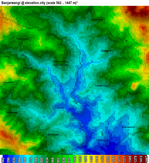
Below is the Elevation map of Banjarwangi, which displays elevation range with different colors. Scale of the first map is from 562 to 1447 m (1844 to 4747 ft) with average elevation of 843.3 meters (=2767 ft) [note 1]
These maps also provides idea of topography and contour of this city, they are displayed at different zoom levels. More info about maps, scale and edge coordinates you can find below images.
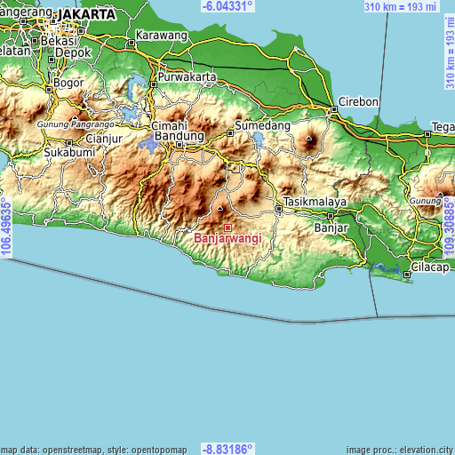
| \ | Map #1 | Topo.Map |
| Scale [m] | 562..1447 m | × |
| Scale [ft] | 1844..4747 ft | × |
| Average | 843.3 m = 2767 ft | × |
| Width | 9.69 km = 6 mi | 310.1 km = 192.7 mi |
| Height | 9.69 km = 6 mi | 310.1 km = 192.7 mi |
| ↑Max Latitude | -7.396222° | -6.04331° |
| Latitude at center | -7.4398° | -7.4398° |
| ↓Min Latitude | -7.483373° | -8.83186° |
| ← Min Longitude | 107.858655° | 106.49635° |
| Longitude center | 107.9026° | 107.9026° |
| →Max Longitude | 107.946545° | 109.30885° |
Nearby cities:
Cities around Banjarwangi sort by population:
• Bayongbong elevation 975 m
20.8 km,  333°
333°
• Gudang 1215 m
18.8 km,  321°
321°
• Cilawu 969 m
18.1 km,  6°
6°
• Sodong Hilir 706 m
17.3 km,  108°
108°
• Jayapura 596 m
17.3 km,  55°
55°
• Cisompet 445 m
16.1 km,  219°
219°
• Salawu 572 m
16 km, 63°
• Cikajang 1253 m
13.8 km,  311°
311°
• Parabon 494 m
10.8 km,  169°
169°
• Kebonkai 852 m
10 km,  134°
134°
• Taraju 876 m
8.9 km,  103°
103°
• Cibitung 582 m
5.3 km,  154°
154°
Multilingual:
 En español:
Banjarwangi elevación 675 m.
 En France:
Banjarwangi élévation 675 m.
 Auf Deutsch:
Banjarwangi höhe über dem Meeresspiegel ist 675 m.

Sources and notes:
- [note 1] Map square and city borders are not equal. Map elevation data is calculated only from area inside that square.
- [src 1] Elevation data from geonames database provided with same terms of usage.
- [src 2] The elevation map of Banjarwangi is generated using elevation data from NASA's 3 arcsec (90m) resolution SRTM data.
- [src 3] Base (background) map © OpenStreetMap contributors tiles are generated by Geofabrik and OpenTopoMap.
Copyright & License:
This Banjarwangi Elevation Map is licensed under CC BY-SA. You may reuse any part from this page, if you give a proper credit by linking to this URL:
 More info on terms of use page.