Banjar elevation
Banjar (West Java), Indonesia elevation is 1874 meters and Banjar elevation in feet is 6148 ft above sea level [src 1]. Banjar is a populated place (feature code) with elevation that is 1683 meters (5522 ft) bigger than average city elevation in Indonesia.
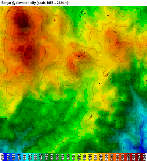
Below is the Elevation map of Banjar, which displays elevation range with different colors. Scale of the first map is from 1058 to 2424 m (3471 to 7953 ft) with average elevation of 1792.5 meters (=5881 ft) [note 1]
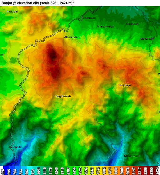
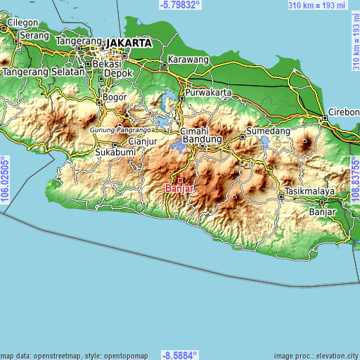
These maps also provides idea of topography and contour of this city, they are displayed at different zoom levels. More info about maps, scale and edge coordinates you can find below images.
| \ | Map #1 | Map #2 | Topo.Map |
| Scale [m] | 1058..2424 m | 626..2424 m | × |
| Scale [ft] | 3471..7953 ft | 2054..7953 ft | × |
| Average | 1792.5 m = 5881 ft | 1545.1 m = 5069 ft | × |
| Width | 9.7 km = 6 mi | 19.39 km = 12 mi | 310.2 km = 192.7 mi |
| Height | 9.7 km = 6 mi | 19.39 km = 12 mi | 310.3 km = 192.8 mi |
| ↑Max Latitude | -7.151899° | -7.108293° | -5.79832° |
| Latitude at center | -7.1955° | -7.1955° | -7.1955° |
| ↓Min Latitude | -7.239097° | -7.28269° | -8.5884° |
| ← Min Longitude | 107.387355° | 107.343409° | 106.02505° |
| Longitude center | 107.4313° | 107.4313° | 107.4313° |
| →Max Longitude | 107.475245° | 107.519191° | 108.83755° |
Nearby cities:
Cities around Banjar sort by population:
• Banjaran elevation 674 m
24 km,  45°
45°
• Soreang 744 m
20.5 km,  27°
27°
• Margahayukencana 668 m
29.2 km, 31°
• Pameungpeuk 665 m
27.4 km,  44°
44°
• Ankola 555 m
35.8 km,  249°
249°
• Sukanagara 871 m
34.9 km,  288°
288°
• Tanggeung 305 m
34.9 km,  256°
256°
• Bungbulang 443 m
34.4 km,  147°
147°
• Kertajadi 29 m
33.8 km,  196°
196°
• Cisewu 615 m
21.3 km,  159°
159°
• Naringgul 565 m
19.2 km,  216°
216°
• Cibungur 932 m
15.4 km,  133°
133°
Multilingual:
 En español:
Banjar elevación 1874 m.
 En France:
Banjar élévation 1874 m.


Sources and notes:
- [note 1] Map square and city borders are not equal. Map elevation data is calculated only from area inside that square.
- [src 1] Elevation data from geonames database provided with same terms of usage.
- [src 2] The elevation map of Banjar is generated using elevation data from NASA's 3 arcsec (90m) resolution SRTM data.
- [src 3] Base (background) map © OpenStreetMap contributors tiles are generated by Geofabrik and OpenTopoMap.
Copyright & License:
This Banjar Elevation Map is licensed under CC BY-SA. You may reuse any part from this page, if you give a proper credit by linking to this URL:
 More info on terms of use page.