Banjarnegara elevation
Banjarnegara (Central Java), Indonesia elevation is 300 meters and Banjarnegara elevation in feet is 984 ft above sea level [src 1]. Banjarnegara is a seat of a second-order administrative division (feature code) with elevation that is 109 meters (358 ft) bigger than average city elevation in Indonesia.
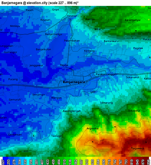
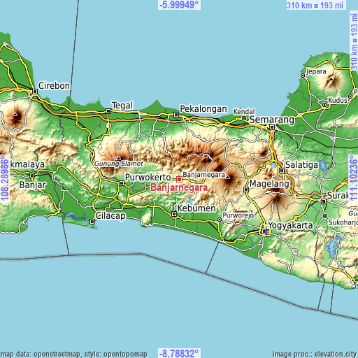
Below is the Elevation map of Banjarnegara, which displays elevation range with different colors. Scale of the first map is from 227 to 896 m (745 to 2940 ft) with average elevation of 374.4 meters (=1228 ft) [note 1]
These maps also provides idea of topography and contour of this city, they are displayed at different zoom levels. More info about maps, scale and edge coordinates you can find below images.
| \ | Map #1 | Topo.Map |
| Scale [m] | 227..896 m | × |
| Scale [ft] | 745..2940 ft | × |
| Average | 374.4 m = 1228 ft | × |
| Width | 9.69 km = 6 mi | 310.1 km = 192.7 mi |
| Height | 9.69 km = 6 mi | 310.1 km = 192.7 mi |
| ↑Max Latitude | -7.352528° | -5.99949° |
| Latitude at center | -7.39611° | -7.39611° |
| ↓Min Latitude | -7.439688° | -8.78832° |
| ← Min Longitude | 109.652165° | 108.28986° |
| Longitude center | 109.69611° | 109.69611° |
| →Max Longitude | 109.740055° | 111.10236° |
Nearby cities:
Cities around Banjarnegara sort by population:
• Kedungwuni elevation 17 m
47.6 km,  353°
353°
• Wonosobo 794 m
23.2 km,  79°
79°
• Sokaraja 48 m
45.5 km,  261°
261°
• Purbalingga 61 m
36.6 km,  271°
271°
• Banyumas 28 m
46.2 km,  253°
253°
• Buaran 21 m
41.7 km,  337°
337°
• Wonopringgo 45 m
46.7 km, 349°
• Gombong 26 m
30.9 km,  220°
220°
• Kutoarjo 20 m
42.9 km,  146°
146°
• Purworejo 71 m
49.3 km,  135°
135°
• Kajen 36 m
42.5 km, 342°
• Kebumen 29 m
30.7 km,  188°
188°
Multilingual:
 En español:
Banjarnegara elevación 300 m.
 En France:
Banjarnegara élévation 300 m.
 Auf Deutsch:
Banjarnegara höhe über dem Meeresspiegel ist 300 m.

Sources and notes:
- [note 1] Map square and city borders are not equal. Map elevation data is calculated only from area inside that square.
- [src 1] Elevation data from geonames database provided with same terms of usage.
- [src 2] The elevation map of Banjarnegara is generated using elevation data from NASA's 3 arcsec (90m) resolution SRTM data.
- [src 3] Base (background) map © OpenStreetMap contributors tiles are generated by Geofabrik and OpenTopoMap.
Copyright & License:
This Banjarnegara Elevation Map is licensed under CC BY-SA. You may reuse any part from this page, if you give a proper credit by linking to this URL:
 More info on terms of use page.