Sokaraja elevation
Sokaraja (Central Java), Indonesia elevation is 48 meters and Sokaraja elevation in feet is 157 ft above sea level [src 1]. Sokaraja is a populated place (feature code) with elevation that is 143 meters (469 ft) smaller than average city elevation in Indonesia.
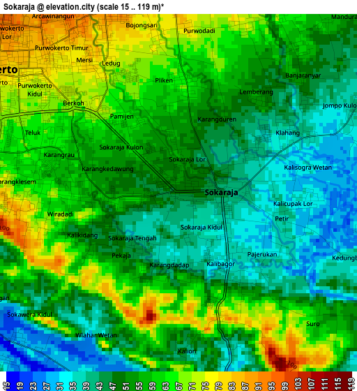
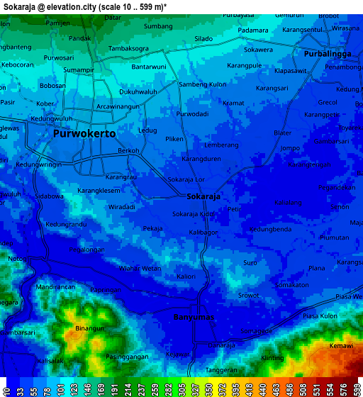
Below is the Elevation map of Sokaraja, which displays elevation range with different colors. Scale of the first map is from 15 to 119 m (49 to 390 ft) with average elevation of 53.9 meters (=177 ft) [note 1]
These maps also provides idea of topography and contour of this city, they are displayed at different zoom levels. More info about maps, scale and edge coordinates you can find below images.
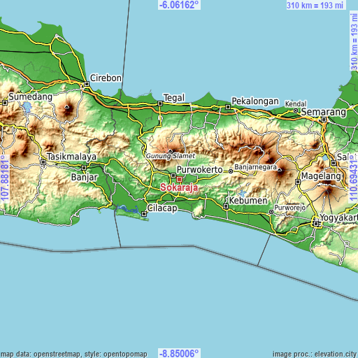
| \ | Map #1 | Map #2 | Topo.Map |
| Scale [m] | 15..119 m | 10..599 m | × |
| Scale [ft] | 49..390 ft | 33..1965 ft | × |
| Average | 53.9 m = 177 ft | 86.1 m = 282 ft | × |
| Width | 9.69 km = 6 mi | 19.38 km = 12 mi | 310 km = 192.6 mi |
| Height | 9.69 km = 6 mi | 19.38 km = 12 mi | 310.1 km = 192.7 mi |
| ↑Max Latitude | -7.414484° | -7.370904° | -6.06162° |
| Latitude at center | -7.45806° | -7.45806° | -7.45806° |
| ↓Min Latitude | -7.501631° | -7.545198° | -8.85006° |
| ← Min Longitude | 109.244115° | 109.200169° | 107.88181° |
| Longitude center | 109.28806° | 109.28806° | 109.28806° |
| →Max Longitude | 109.332005° | 109.375951° | 110.69431° |
Nearby cities:
Cities around Sokaraja sort by population:
• Purwokerto elevation 81 m
7.2 km,  304°
304°
• Purbalingga 61 m
11.4 km,  47°
47°
• Banyumas 28 m
6.3 km,  173°
173°
• Baturaden 980 m
19.3 km,  335°
335°
• Wangon 32 m
26.6 km,  255°
255°
• Kroya 18 m
20 km,  193°
193°
• Adipala 14 m
27.1 km,  214°
214°
• Kesugihan 11 m
25.5 km,  226°
226°
• Klapagada 8 m
24 km,  219°
219°
• Sampang 15 m
15.4 km, 220°
• Rawalo 18 m
14.9 km, 233°
• Gambarsari 20 m
12.6 km, 229°
Multilingual:
 En español:
Sokaraja elevación 48 m.
 En France:
Sokaraja élévation 48 m.


Sources and notes:
- [note 1] Map square and city borders are not equal. Map elevation data is calculated only from area inside that square.
- [src 1] Elevation data from geonames database provided with same terms of usage.
- [src 2] The elevation map of Sokaraja is generated using elevation data from NASA's 3 arcsec (90m) resolution SRTM data.
- [src 3] Base (background) map © OpenStreetMap contributors tiles are generated by Geofabrik and OpenTopoMap.
Copyright & License:
This Sokaraja Elevation Map is licensed under CC BY-SA. You may reuse any part from this page, if you give a proper credit by linking to this URL:
 More info on terms of use page.