Purbalingga elevation
Purbalingga (Central Java), Indonesia elevation is 61 meters and Purbalingga elevation in feet is 200 ft above sea level [src 1]. Purbalingga is a seat of a second-order administrative division (feature code) with elevation that is 130 meters (427 ft) smaller than average city elevation in Indonesia.
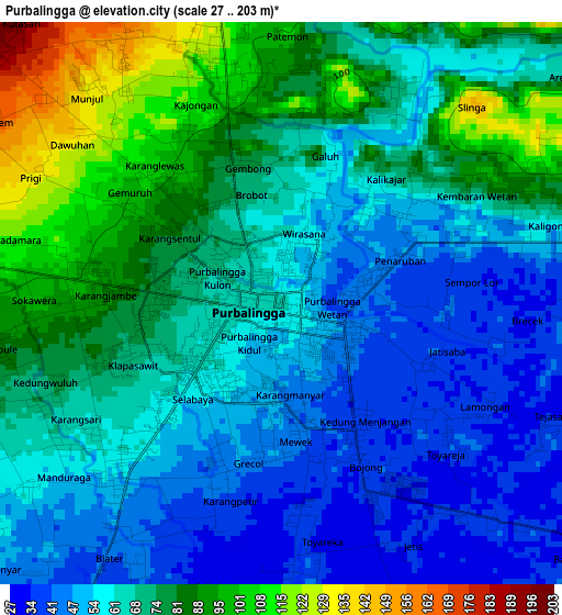
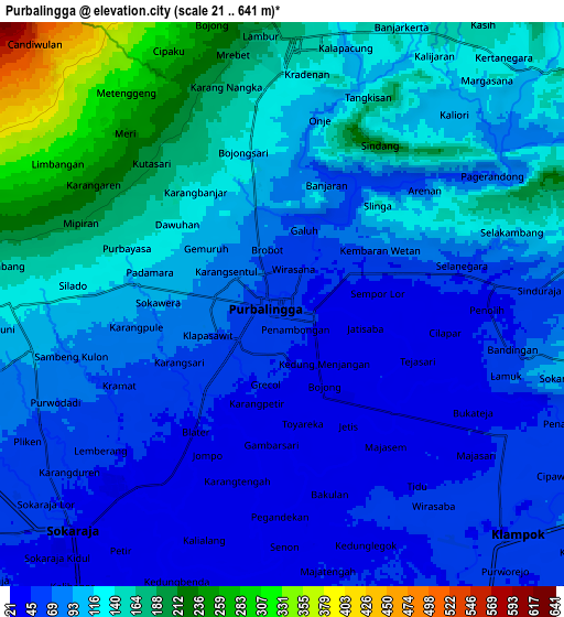
Below is the Elevation map of Purbalingga, which displays elevation range with different colors. Scale of the first map is from 27 to 203 m (89 to 666 ft) with average elevation of 67.1 meters (=220 ft) [note 1]
These maps also provides idea of topography and contour of this city, they are displayed at different zoom levels. More info about maps, scale and edge coordinates you can find below images.
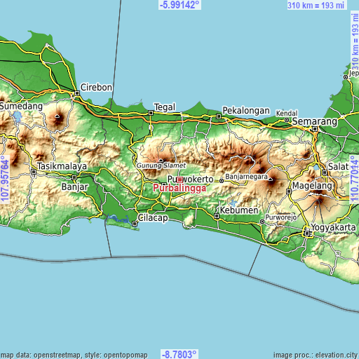
| \ | Map #1 | Map #2 | Topo.Map |
| Scale [m] | 27..203 m | 21..641 m | × |
| Scale [ft] | 89..666 ft | 69..2103 ft | × |
| Average | 67.1 m = 220 ft | 104.5 m = 343 ft | × |
| Width | 9.69 km = 6 mi | 19.38 km = 12 mi | 310.1 km = 192.7 mi |
| Height | 9.69 km = 6 mi | 19.38 km = 12 mi | 310.1 km = 192.7 mi |
| ↑Max Latitude | -7.344477° | -7.30089° | -5.99142° |
| Latitude at center | -7.38806° | -7.38806° | -7.38806° |
| ↓Min Latitude | -7.431638° | -7.475212° | -8.7803° |
| ← Min Longitude | 109.319945° | 109.275999° | 107.95764° |
| Longitude center | 109.36389° | 109.36389° | 109.36389° |
| →Max Longitude | 109.407835° | 109.451781° | 110.77014° |
Nearby cities:
Cities around Purbalingga sort by population:
• Purwokerto elevation 81 m
14.7 km,  255°
255°
• Sokaraja 48 m
11.4 km,  227°
227°
• Banyumas 28 m
16 km,  208°
208°
• Baturaden 980 m
19 km,  301°
301°
• Gombong 26 m
29.5 km,  145°
145°
• Randudongkal 216 m
32.5 km,  352°
352°
• Kroya 18 m
30.2 km, 205°
• Banjarnegara 300 m
36.6 km,  91°
91°
• Klapagada 8 m
35.3 km,  222°
222°
• Sampang 15 m
26.8 km, 223°
• Rawalo 18 m
26.2 km, 230°
• Gambarsari 20 m
24 km, 228°
Multilingual:
 En español:
Purbalingga elevación 61 m.
 En France:
Purbalingga élévation 61 m.
 Auf Deutsch:
Purbalingga höhe über dem Meeresspiegel ist 61 m.

Sources and notes:
- [note 1] Map square and city borders are not equal. Map elevation data is calculated only from area inside that square.
- [src 1] Elevation data from geonames database provided with same terms of usage.
- [src 2] The elevation map of Purbalingga is generated using elevation data from NASA's 3 arcsec (90m) resolution SRTM data.
- [src 3] Base (background) map © OpenStreetMap contributors tiles are generated by Geofabrik and OpenTopoMap.
Copyright & License:
This Purbalingga Elevation Map is licensed under CC BY-SA. You may reuse any part from this page, if you give a proper credit by linking to this URL:
 More info on terms of use page.