Tanjungagung elevation
Tanjungagung (South Sumatra), Indonesia elevation is 129 meters and Tanjungagung elevation in feet is 423 ft above sea level [src 1]. Tanjungagung is a populated place (feature code) with elevation that is 62 meters (203 ft) smaller than average city elevation in Indonesia.
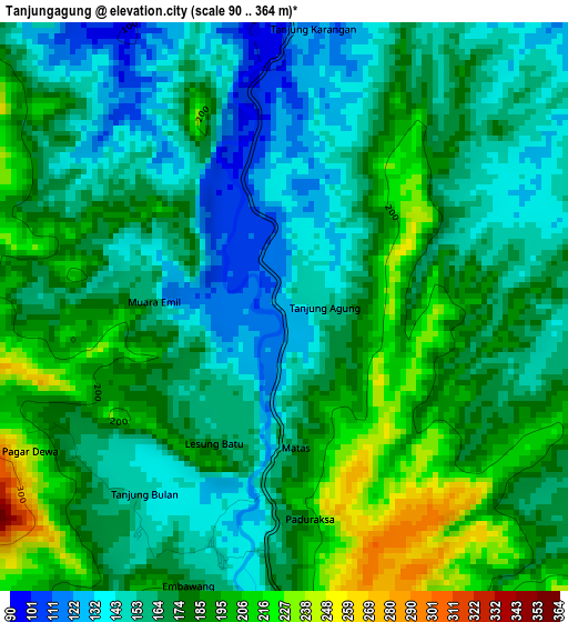
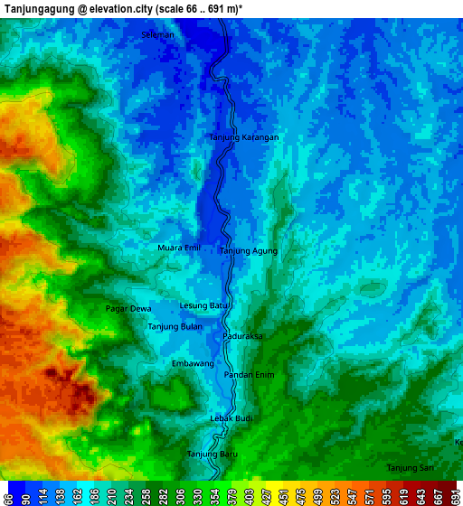
Below is the Elevation map of Tanjungagung, which displays elevation range with different colors. Scale of the first map is from 90 to 364 m (295 to 1194 ft) with average elevation of 171.3 meters (=562 ft) [note 1]
These maps also provides idea of topography and contour of this city, they are displayed at different zoom levels. More info about maps, scale and edge coordinates you can find below images.
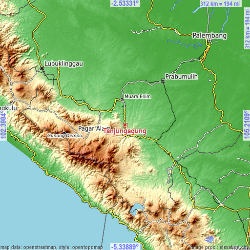
| \ | Map #1 | Map #2 | Topo.Map |
| Scale [m] | 90..364 m | 66..691 m | × |
| Scale [ft] | 295..1194 ft | 217..2267 ft | × |
| Average | 171.3 m = 562 ft | 230.6 m = 757 ft | × |
| Width | 9.75 km = 6.1 mi | 19.5 km = 12.1 mi | 312 km = 193.9 mi |
| Height | 9.75 km = 6.1 mi | 19.5 km = 12.1 mi | 312 km = 193.9 mi |
| ↑Max Latitude | -3.893437° | -3.849592° | -2.53331° |
| Latitude at center | -3.93728° | -3.93728° | -3.93728° |
| ↓Min Latitude | -3.98112° | -4.024959° | -5.33889° |
| ← Min Longitude | 103.760705° | 103.716759° | 102.3984° |
| Longitude center | 103.80465° | 103.80465° | 103.80465° |
| →Max Longitude | 103.848595° | 103.892541° | 105.2109° |
Nearby cities:
Cities around Tanjungagung sort by population:
• Baturaja elevation 69 m
45.5 km,  117°
117°
• Pagar Alam 720 m
62.6 km,  261°
261°
• Lahat 115 m
33.6 km,  300°
300°
• Bunga Mas 84 m
55 km, 298°
• Gunungmegang Dalam 27 m
54.7 km,  7°
7°
• Kotaagung 748 m
43.9 km,  250°
250°
• Muara Enim 41 m
32.3 km,  353°
353°
• Pulaupinang 175 m
32 km,  279°
279°
• Muaradua 810 m
29.3 km,  226°
226°
• Suban Jeriji 87 m
27.6 km,  39°
39°
• Negeriagung 62 m
25.4 km,  318°
318°
• Pengandonan 155 m
15.3 km,  148°
148°
Multilingual:
 En español:
Tanjungagung elevación 129 m.
 En France:
Tanjungagung élévation 129 m.
 Auf Deutsch:
Tanjungagung höhe über dem Meeresspiegel ist 129 m.

Sources and notes:
- [note 1] Map square and city borders are not equal. Map elevation data is calculated only from area inside that square.
- [src 1] Elevation data from geonames database provided with same terms of usage.
- [src 2] The elevation map of Tanjungagung is generated using elevation data from NASA's 3 arcsec (90m) resolution SRTM data.
- [src 3] Base (background) map © OpenStreetMap contributors tiles are generated by Geofabrik and OpenTopoMap.
Copyright & License:
This Tanjungagung Elevation Map is licensed under CC BY-SA. You may reuse any part from this page, if you give a proper credit by linking to this URL:
 More info on terms of use page.