Lahat elevation
Lahat (South Sumatra, Lahat Regency), Indonesia elevation is 115 meters and Lahat elevation in feet is 377 ft above sea level [src 1]. Lahat is a seat of a second-order administrative division (feature code) with elevation that is 76 meters (249 ft) smaller than average city elevation in Indonesia.
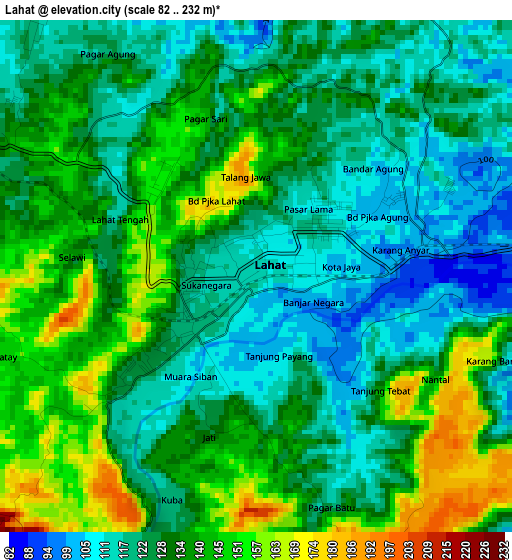
Below is the Elevation map of Lahat, which displays elevation range with different colors. Scale of the first map is from 82 to 232 m (269 to 761 ft) with average elevation of 130.9 meters (=429 ft) [note 1]
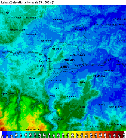
These maps also provides idea of topography and contour of this city, they are displayed at different zoom levels. More info about maps, scale and edge coordinates you can find below images.
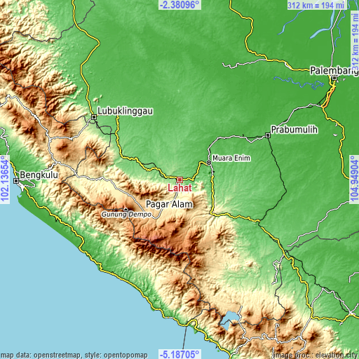
| \ | Map #1 | Map #2 | Topo.Map |
| Scale [m] | 82..232 m | 63..508 m | × |
| Scale [ft] | 269..761 ft | 207..1667 ft | × |
| Average | 130.9 m = 429 ft | 144.9 m = 475 ft | × |
| Width | 9.75 km = 6.1 mi | 19.5 km = 12.1 mi | 312 km = 193.9 mi |
| Height | 9.75 km = 6.1 mi | 19.5 km = 12.1 mi | 312 km = 193.9 mi |
| ↑Max Latitude | -3.741289° | -3.697437° | -2.38096° |
| Latitude at center | -3.78514° | -3.78514° | -3.78514° |
| ↓Min Latitude | -3.828988° | -3.872834° | -5.18705° |
| ← Min Longitude | 103.498845° | 103.454899° | 102.13654° |
| Longitude center | 103.54279° | 103.54279° | 103.54279° |
| →Max Longitude | 103.586735° | 103.630681° | 104.94904° |
Nearby cities:
Cities around Lahat sort by population:
• Pagar Alam elevation 720 m
42.3 km,  230°
230°
• Tanjungagung 129 m
33.6 km,  120°
120°
• Muarapinang 440 m
54.8 km,  262°
262°
• Gunungmegang Dalam 27 m
52 km,  44°
44°
• Pengandonan 155 m
47.6 km,  128°
128°
• Suban Jeriji 87 m
46.9 km,  84°
84°
• Muaradua 810 m
37.8 km,  168°
168°
• Kotaagung 748 m
33.8 km,  201°
201°
• Muara Enim 41 m
29.5 km,  59°
59°
• Bunga Mas 84 m
21.5 km,  295°
295°
• Negeriagung 62 m
12.2 km, 80°
• Pulaupinang 175 m
12 km,  191°
191°
Multilingual:
 En español:
Lahat elevación 115 m.
 En France:
Lahat élévation 115 m.


Sources and notes:
- [note 1] Map square and city borders are not equal. Map elevation data is calculated only from area inside that square.
- [src 1] Elevation data from geonames database provided with same terms of usage.
- [src 2] The elevation map of Lahat is generated using elevation data from NASA's 3 arcsec (90m) resolution SRTM data.
- [src 3] Base (background) map © OpenStreetMap contributors tiles are generated by Geofabrik and OpenTopoMap.
Copyright & License:
This Lahat Elevation Map is licensed under CC BY-SA. You may reuse any part from this page, if you give a proper credit by linking to this URL:
 More info on terms of use page.