Pagar Alam elevation
Pagar Alam (South Sumatra, Lahat Regency), Indonesia elevation is 720 meters and Pagar Alam elevation in feet is 2362 ft above sea level [src 1]. Pagar Alam is a seat of a third-order administrative division (feature code) with elevation that is 529 meters (1736 ft) bigger than average city elevation in Indonesia.
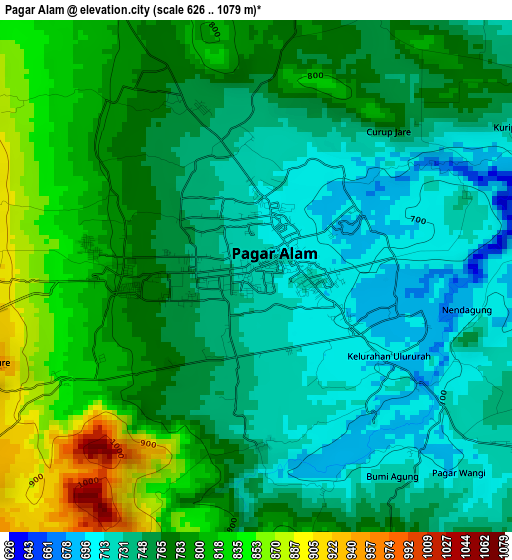
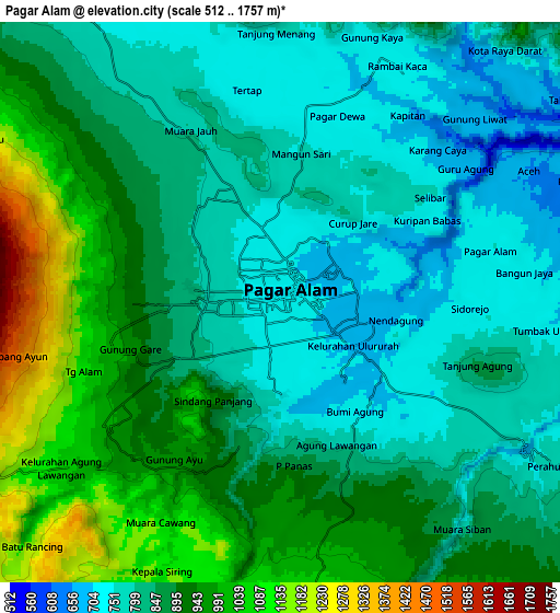
Below is the Elevation map of Pagar Alam, which displays elevation range with different colors. Scale of the first map is from 626 to 1079 m (2054 to 3540 ft) with average elevation of 768.8 meters (=2522 ft) [note 1]
These maps also provides idea of topography and contour of this city, they are displayed at different zoom levels. More info about maps, scale and edge coordinates you can find below images.
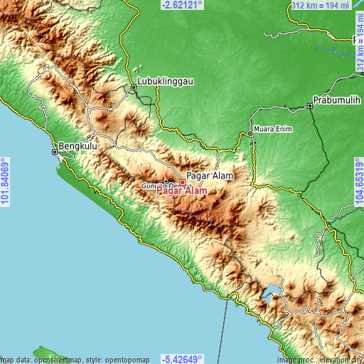
| \ | Map #1 | Map #2 | Topo.Map |
| Scale [m] | 626..1079 m | 512..1757 m | × |
| Scale [ft] | 2054..3540 ft | 1680..5764 ft | × |
| Average | 768.8 m = 2522 ft | 868.1 m = 2848 ft | × |
| Width | 9.75 km = 6.1 mi | 19.5 km = 12.1 mi | 311.9 km = 193.8 mi |
| Height | 9.75 km = 6.1 mi | 19.5 km = 12.1 mi | 311.9 km = 193.8 mi |
| ↑Max Latitude | -3.981222° | -3.937381° | -2.62121° |
| Latitude at center | -4.02506° | -4.02506° | -4.02506° |
| ↓Min Latitude | -4.068896° | -4.112729° | -5.42649° |
| ← Min Longitude | 103.202995° | 103.159049° | 101.84069° |
| Longitude center | 103.24694° | 103.24694° | 103.24694° |
| →Max Longitude | 103.290885° | 103.334831° | 104.65319° |
Nearby cities:
Cities around Pagar Alam sort by population:
• Lahat elevation 115 m
42.3 km,  50°
50°
• Manna 31 m
62 km,  217°
217°
• Padangtepung 276 m
58.6 km,  301°
301°
• Negeriagung 62 m
53.3 km,  57°
57°
• Tebing Tinggi 123 m
52.5 km,  338°
338°
• Masat 127 m
51.1 km, 219°
• Muaradua 810 m
41.8 km,  104°
104°
• Bunga Mas 84 m
38.5 km,  20°
20°
• Pulaupinang 175 m
33.8 km, 63°
• Muarapinang 440 m
29 km,  312°
312°
• Tanjungsakti 546 m
25.3 km,  231°
231°
• Kotaagung 748 m
21 km, 103°
Multilingual:
 En español:
Pagar Alam elevación 720 m.
 En France:
Pagar Alam élévation 720 m.
 Auf Deutsch:
Pagar Alam höhe über dem Meeresspiegel ist 720 m.

Sources and notes:
- [note 1] Map square and city borders are not equal. Map elevation data is calculated only from area inside that square.
- [src 1] Elevation data from geonames database provided with same terms of usage.
- [src 2] The elevation map of Pagar Alam is generated using elevation data from NASA's 3 arcsec (90m) resolution SRTM data.
- [src 3] Base (background) map © OpenStreetMap contributors tiles are generated by Geofabrik and OpenTopoMap.
Copyright & License:
This Pagar Alam Elevation Map is licensed under CC BY-SA. You may reuse any part from this page, if you give a proper credit by linking to this URL:
 More info on terms of use page.