Baturaja elevation
Baturaja (South Sumatra), Indonesia elevation is 69 meters and Baturaja elevation in feet is 226 ft above sea level [src 1]. Baturaja is a seat of a second-order administrative division (feature code) with elevation that is 122 meters (400 ft) smaller than average city elevation in Indonesia.
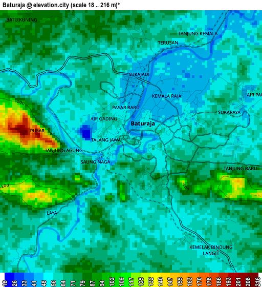
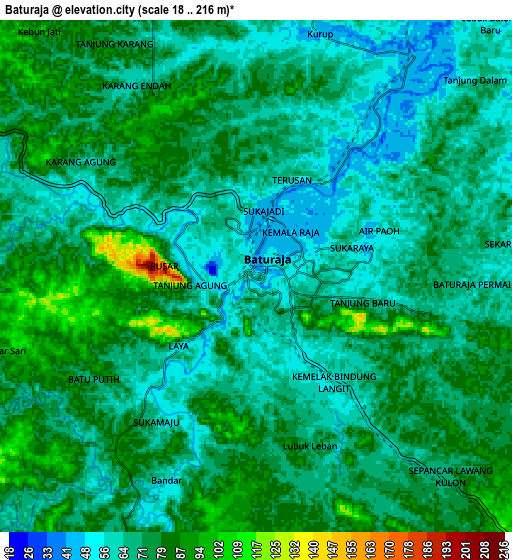
Below is the Elevation map of Baturaja, which displays elevation range with different colors. Scale of the first map is from 18 to 216 m (59 to 709 ft) with average elevation of 66.2 meters (=217 ft) [note 1]
These maps also provides idea of topography and contour of this city, they are displayed at different zoom levels. More info about maps, scale and edge coordinates you can find below images.
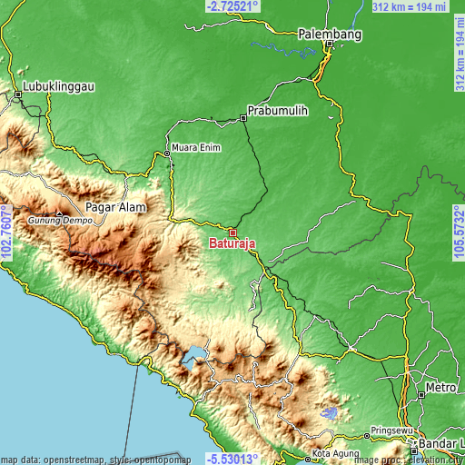
| \ | Map #1 | Map #2 | Topo.Map |
| Scale [m] | 18..216 m | 18..216 m | × |
| Scale [ft] | 59..709 ft | 59..709 ft | × |
| Average | 66.2 m = 217 ft | 71.9 m = 236 ft | × |
| Width | 9.75 km = 6.1 mi | 19.49 km = 12.1 mi | 311.9 km = 193.8 mi |
| Height | 9.75 km = 6.1 mi | 19.49 km = 12.1 mi | 311.9 km = 193.8 mi |
| ↑Max Latitude | -4.085078° | -4.041243° | -2.72521° |
| Latitude at center | -4.12891° | -4.12891° | -4.12891° |
| ↓Min Latitude | -4.17274° | -4.216568° | -5.53013° |
| ← Min Longitude | 104.123005° | 104.079059° | 102.7607° |
| Longitude center | 104.16695° | 104.16695° | 104.16695° |
| →Max Longitude | 104.210895° | 104.254841° | 105.5732° |
Nearby cities:
Cities around Baturaja sort by population:
• Tanjungagung elevation 129 m
45.5 km,  297°
297°
• Negeriagung 62 m
69.9 km,  305°
305°
• Muara Enim 41 m
69.1 km,  320°
320°
• Muarakuang 21 m
67.9 km,  40°
40°
• Muaradua 810 m
61.5 km,  271°
271°
• Blambangan Umpu 62 m
57 km,  136°
136°
• Suban Jeriji 87 m
48.1 km,  332°
332°
• Muara Dua 135 m
46 km,  192°
192°
• Peninjawan 34 m
37.5 km, 39°
• Simpang 125 m
35.7 km,  175°
175°
• Pengandonan 155 m
33.2 km,  284°
284°
• Martapura 93 m
29.1 km, 136°
Multilingual:
 En español:
Baturaja elevación 69 m.
 En France:
Baturaja élévation 69 m.


Sources and notes:
- [note 1] Map square and city borders are not equal. Map elevation data is calculated only from area inside that square.
- [src 1] Elevation data from geonames database provided with same terms of usage.
- [src 2] The elevation map of Baturaja is generated using elevation data from NASA's 3 arcsec (90m) resolution SRTM data.
- [src 3] Base (background) map © OpenStreetMap contributors tiles are generated by Geofabrik and OpenTopoMap.
Copyright & License:
This Baturaja Elevation Map is licensed under CC BY-SA. You may reuse any part from this page, if you give a proper credit by linking to this URL:
 More info on terms of use page.