Vácszentlászló elevation
Vácszentlászló (Pest), Hungary elevation is 165 meters and Vácszentlászló elevation in feet is 541 ft above sea level [src 1]. Vácszentlászló is a populated place (feature code) with elevation that is 36 meters (118 ft) bigger than average city elevation in Hungary.
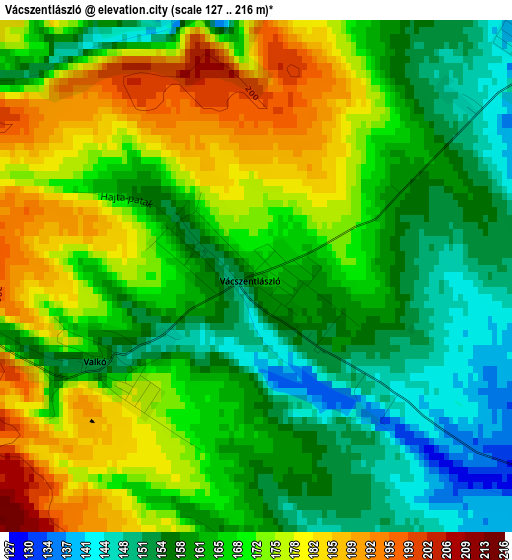
Below is the Elevation map of Vácszentlászló, which displays elevation range with different colors. Scale of the first map is from 127 to 216 m (417 to 709 ft) with average elevation of 166.3 meters (=546 ft) [note 1]
These maps also provides idea of topography and contour of this city, they are displayed at different zoom levels. More info about maps, scale and edge coordinates you can find below images.
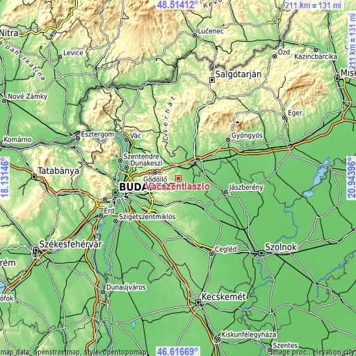
| \ | Map #1 | Topo.Map |
| Scale [m] | 127..216 m | × |
| Scale [ft] | 417..709 ft | × |
| Average | 166.3 m = 546 ft | × |
| Width | 6.59 km = 4.1 mi | 211 km = 131.1 mi |
| Height | 6.59 km = 4.1 mi | 211 km = 131.1 mi |
| ↑Max Latitude | 47.603639° | 48.51412° |
| Latitude at center | 47.574° | 47.574° |
| ↓Min Latitude | 47.544344° | 46.61669° |
| ← Min Longitude | 19.493765° | 18.13146° |
| Longitude center | 19.53771° | 19.53771° |
| →Max Longitude | 19.581655° | 20.94396° |
Nearby cities:
Cities around Vácszentlászló sort by population:
• Isaszeg elevation 182 m
11.3 km,  244°
244°
• Tura 115 m
6.3 km,  51°
51°
• Aszód 128 m
9.7 km,  332°
332°
• Kartal 155 m
10.8 km,  1°
1°
• Dány 163 m
6 km,  175°
175°
• Kóka 145 m
10.3 km,  162°
162°
• Bag 136 m
7.8 km, 328°
• Boldog 112 m
11.7 km,  74°
74°
• Hévízgyörk 117 m
6.8 km,  346°
346°
• Galgahévíz 126 m
5.2 km,  24°
24°
• Zsámbok 130 m
6.4 km,  121°
121°
• Valkó 155 m
2.2 km, 239°
Multilingual:
 En español:
Vácszentlászló elevación 165 m.
 En France:
Vácszentlászló élévation 165 m.
 Auf Deutsch:
Vácszentlászló höhe über dem Meeresspiegel ist 165 m.

Sources and notes:
- [note 1] Map square and city borders are not equal. Map elevation data is calculated only from area inside that square.
- [src 1] Elevation data from geonames database provided with same terms of usage.
- [src 2] The elevation map of Vácszentlászló is generated using elevation data from NASA's 3 arcsec (90m) resolution SRTM data.
- [src 3] Base (background) map © OpenStreetMap contributors tiles are generated by Geofabrik and OpenTopoMap.
Copyright & License:
This Vácszentlászló Elevation Map is licensed under CC BY-SA. You may reuse any part from this page, if you give a proper credit by linking to this URL:
 More info on terms of use page.