Gracias elevation
Gracias (Lempira), Honduras elevation is 798 meters and Gracias elevation in feet is 2618 ft above sea level [src 1]. Gracias is a seat of a first-order administrative division (feature code) with elevation that is 255 meters (837 ft) bigger than average city elevation in Honduras.
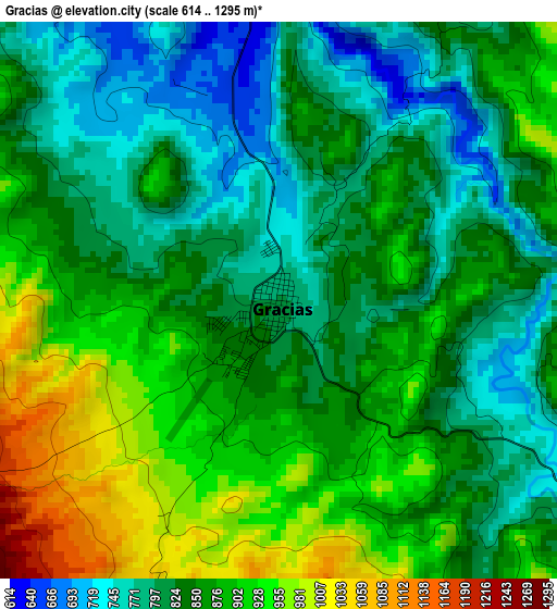
Below is the Elevation map of Gracias, which displays elevation range with different colors. Scale of the first map is from 614 to 1295 m (2014 to 4249 ft) with average elevation of 854.3 meters (=2803 ft) [note 1]
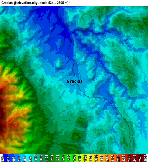
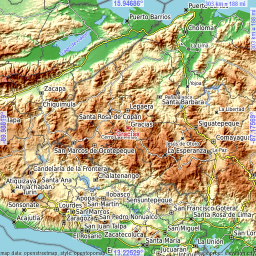
These maps also provides idea of topography and contour of this city, they are displayed at different zoom levels. More info about maps, scale and edge coordinates you can find below images.
| \ | Map #1 | Map #2 | Topo.Map |
| Scale [m] | 614..1295 m | 534..2605 m | × |
| Scale [ft] | 2014..4249 ft | 1752..8547 ft | × |
| Average | 854.3 m = 2803 ft | 1027.9 m = 3372 ft | × |
| Width | 9.46 km = 5.9 mi | 18.91 km = 11.8 mi | 302.6 km = 188 mi |
| Height | 9.46 km = 5.9 mi | 18.91 km = 11.8 mi | 302.6 km = 188 mi |
| ↑Max Latitude | 14.632804° | 14.67532° | 15.94686° |
| Latitude at center | 14.59028° | 14.59028° | 14.59028° |
| ↓Min Latitude | 14.547748° | 14.505207° | 13.22529° |
| ← Min Longitude | -88.625885° | -88.669831° | -89.98819° |
| Longitude center | -88.58194° | -88.58194° | -88.58194° |
| →Max Longitude | -88.537995° | -88.494049° | -87.17569° |
Nearby cities:
Cities around Gracias sort by population:
• Santa Rosa de Copán elevation 1146 m
28.9 km,  312°
312°
• Corquín 909 m
30.8 km,  265°
265°
• Lepaera 1031 m
21.5 km,  359°
359°
• Cucuyagua 775 m
31.3 km,  282°
282°
• Belén Gualcho 1783 m
26.3 km,  243°
243°
• San Juan de Opoa 743 m
24.9 km,  329°
329°
• La Libertad 976 m
23.3 km, 359°
• Ojos de Agua 895 m
28 km,  295°
295°
• Las Tejeras 936 m
23.4 km, 355°
• Yaruchel 1374 m
26 km,  255°
255°
• Berlín 1091 m
28.4 km,  18°
18°
• Taragual 1116 m
20.7 km,  30°
30°
Multilingual:
 En español:
Gracias elevación 798 m.
 En France:
Gracias élévation 798 m.


Sources and notes:
- [note 1] Map square and city borders are not equal. Map elevation data is calculated only from area inside that square.
- [src 1] Elevation data from geonames database provided with same terms of usage.
- [src 2] The elevation map of Gracias is generated using elevation data from NASA's 3 arcsec (90m) resolution SRTM data.
- [src 3] Base (background) map © OpenStreetMap contributors tiles are generated by Geofabrik and OpenTopoMap.
Copyright & License:
This Gracias Elevation Map is licensed under CC BY-SA. You may reuse any part from this page, if you give a proper credit by linking to this URL:
 More info on terms of use page.