Taragual elevation
Taragual (Lempira), Honduras elevation is 1116 meters and Taragual elevation in feet is 3661 ft above sea level [src 1]. Taragual is a populated place (feature code) with elevation that is 573 meters (1880 ft) bigger than average city elevation in Honduras.
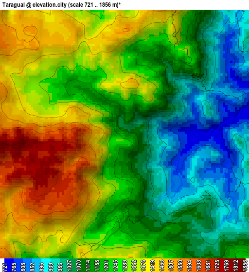
Below is the Elevation map of Taragual, which displays elevation range with different colors. Scale of the first map is from 721 to 1856 m (2365 to 6089 ft) with average elevation of 1231.2 meters (=4039 ft) [note 1]
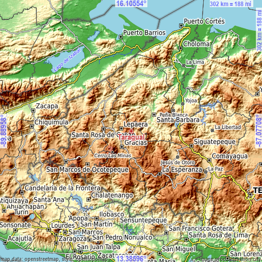
These maps also provides idea of topography and contour of this city, they are displayed at different zoom levels. More info about maps, scale and edge coordinates you can find below images.
| \ | Map #1 | Topo.Map |
| Scale [m] | 721..1856 m | × |
| Scale [ft] | 2365..6089 ft | × |
| Average | 1231.2 m = 4039 ft | × |
| Width | 9.45 km = 5.9 mi | 302.4 km = 187.9 mi |
| Height | 9.45 km = 5.9 mi | 302.4 km = 187.9 mi |
| ↑Max Latitude | 14.792493° | 16.10554° |
| Latitude at center | 14.75° | 14.75° |
| ↓Min Latitude | 14.707499° | 13.38596° |
| ← Min Longitude | -88.527275° | -89.88958° |
| Longitude center | -88.48333° | -88.48333° |
| →Max Longitude | -88.439385° | -87.07708° |
Nearby cities:
Cities around Taragual sort by population:
• Gracias elevation 798 m
20.7 km,  210°
210°
• Lepaera 1031 m
11.4 km,  289°
289°
• La Unión 1081 m
11.6 km,  50°
50°
• Arada 433 m
22.6 km,  60°
60°
• El Níspero 686 m
16.2 km,  83°
83°
• San Vicente Centenario 302 m
26.1 km, 55°
• Atima 837 m
20.4 km,  0°
0°
• San Juan de Opoa 743 m
23.6 km,  279°
279°
• La Libertad 976 m
12.1 km,  297°
297°
• Las Tejeras 936 m
13.7 km, 293°
• Nueva Jalapa 566 m
24.6 km,  41°
41°
• Berlín 1091 m
9.4 km,  349°
349°
Multilingual:
 En español:
Taragual elevación 1116 m.
 En France:
Taragual élévation 1116 m.
 Auf Deutsch:
Taragual höhe über dem Meeresspiegel ist 1116 m.

Sources and notes:
- [note 1] Map square and city borders are not equal. Map elevation data is calculated only from area inside that square.
- [src 1] Elevation data from geonames database provided with same terms of usage.
- [src 2] The elevation map of Taragual is generated using elevation data from NASA's 3 arcsec (90m) resolution SRTM data.
- [src 3] Base (background) map © OpenStreetMap contributors tiles are generated by Geofabrik and OpenTopoMap.
Copyright & License:
This Taragual Elevation Map is licensed under CC BY-SA. You may reuse any part from this page, if you give a proper credit by linking to this URL:
 More info on terms of use page.