Berlín elevation
Berlín (Santa Bárbara), Honduras elevation is 1091 meters and Berlín elevation in feet is 3579 ft above sea level [src 1]. Berlín is a populated place (feature code) with elevation that is 548 meters (1798 ft) bigger than average city elevation in Honduras.
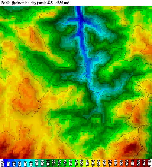
Below is the Elevation map of Berlín, which displays elevation range with different colors. Scale of the first map is from 835 to 1659 m (2740 to 5443 ft) with average elevation of 1241.7 meters (=4074 ft) [note 1]
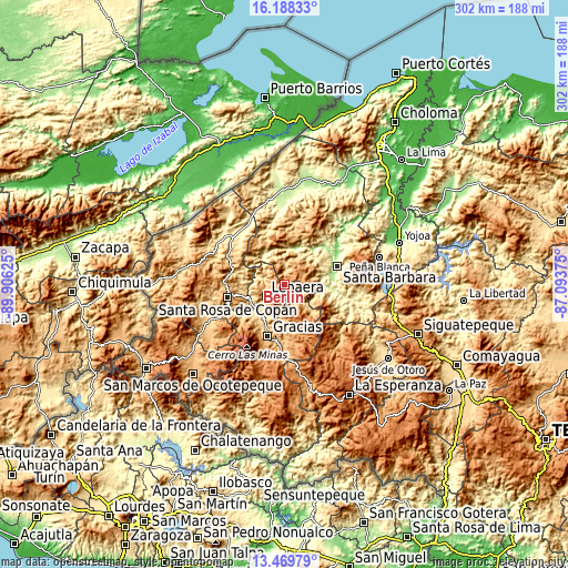
These maps also provides idea of topography and contour of this city, they are displayed at different zoom levels. More info about maps, scale and edge coordinates you can find below images.
| \ | Map #1 | Topo.Map |
| Scale [m] | 835..1659 m | × |
| Scale [ft] | 2740..5443 ft | × |
| Average | 1241.7 m = 4074 ft | × |
| Width | 9.45 km = 5.9 mi | 302.3 km = 187.8 mi |
| Height | 9.45 km = 5.9 mi | 302.3 km = 187.8 mi |
| ↑Max Latitude | 14.875807° | 16.18833° |
| Latitude at center | 14.83333° | 14.83333° |
| ↓Min Latitude | 14.790845° | 13.46979° |
| ← Min Longitude | -88.543945° | -89.90625° |
| Longitude center | -88.5° | -88.5° |
| →Max Longitude | -88.456055° | -87.09375° |
Nearby cities:
Cities around Berlín sort by population:
• Naranjito elevation 921 m
23.6 km,  303°
303°
• San Nicolás 561 m
22.6 km,  60°
60°
• Lepaera 1031 m
10.5 km,  238°
238°
• La Unión 1081 m
10.9 km,  99°
99°
• Arada 433 m
21.6 km,  85°
85°
• El Níspero 686 m
19.4 km,  112°
112°
• Atima 837 m
11.3 km,  9°
9°
• San Juan de Opoa 743 m
22.2 km,  255°
255°
• La Libertad 976 m
9.7 km,  247°
247°
• Las Tejeras 936 m
11.4 km, 250°
• Nueva Jalapa 566 m
20.2 km, 62°
• Taragual 1116 m
9.4 km,  169°
169°
Multilingual:
 En español:
Berlín elevación 1091 m.
 En France:
Berlín élévation 1091 m.


Sources and notes:
- [note 1] Map square and city borders are not equal. Map elevation data is calculated only from area inside that square.
- [src 1] Elevation data from geonames database provided with same terms of usage.
- [src 2] The elevation map of Berlín is generated using elevation data from NASA's 3 arcsec (90m) resolution SRTM data.
- [src 3] Base (background) map © OpenStreetMap contributors tiles are generated by Geofabrik and OpenTopoMap.
Copyright & License:
This Berlín Elevation Map is licensed under CC BY-SA. You may reuse any part from this page, if you give a proper credit by linking to this URL:
 More info on terms of use page.