La Unión elevation
La Unión (Lempira), Honduras elevation is 1081 meters and La Unión elevation in feet is 3547 ft above sea level [src 1]. La Unión is a populated place (feature code) with elevation that is 538 meters (1765 ft) bigger than average city elevation in Honduras.
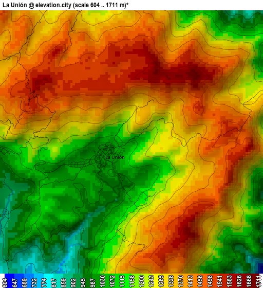
Below is the Elevation map of La Unión, which displays elevation range with different colors. Scale of the first map is from 604 to 1711 m (1982 to 5614 ft) with average elevation of 1271.6 meters (=4172 ft) [note 1]
These maps also provides idea of topography and contour of this city, they are displayed at different zoom levels. More info about maps, scale and edge coordinates you can find below images.
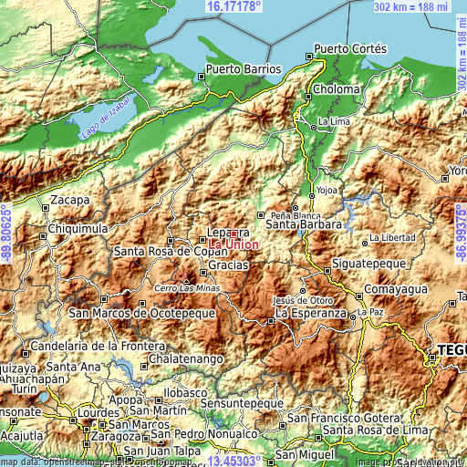
| \ | Map #1 | Topo.Map |
| Scale [m] | 604..1711 m | × |
| Scale [ft] | 1982..5614 ft | × |
| Average | 1271.6 m = 4172 ft | × |
| Width | 9.45 km = 5.9 mi | 302.3 km = 187.8 mi |
| Height | 9.45 km = 5.9 mi | 302.3 km = 187.8 mi |
| ↑Max Latitude | 14.85915° | 16.17178° |
| Latitude at center | 14.81667° | 14.81667° |
| ↓Min Latitude | 14.774182° | 13.45303° |
| ← Min Longitude | -88.443945° | -89.80625° |
| Longitude center | -88.4° | -88.4° |
| →Max Longitude | -88.356055° | -86.99375° |
Nearby cities:
Cities around La Unión sort by population:
• Santa Bárbara elevation 256 m
21 km,  57°
57°
• San Nicolás 561 m
15.8 km,  34°
34°
• Lepaera 1031 m
20.1 km,  259°
259°
• Arada 433 m
11.4 km,  70°
70°
• El Níspero 686 m
9.1 km,  127°
127°
• San Vicente Centenario 302 m
14.6 km, 59°
• Atima 837 m
15.8 km,  325°
325°
• La Libertad 976 m
19.8 km, 264°
• Ceguaca 520 m
21.6 km,  94°
94°
• Nueva Jalapa 566 m
13.2 km, 32°
• Berlín 1091 m
10.9 km,  279°
279°
• Taragual 1116 m
11.6 km,  230°
230°
Multilingual:
 En español:
La Unión elevación 1081 m.
 En France:
La Unión élévation 1081 m.
 Auf Deutsch:
La Unión höhe über dem Meeresspiegel ist 1081 m.

Sources and notes:
- [note 1] Map square and city borders are not equal. Map elevation data is calculated only from area inside that square.
- [src 1] Elevation data from geonames database provided with same terms of usage.
- [src 2] The elevation map of La Unión is generated using elevation data from NASA's 3 arcsec (90m) resolution SRTM data.
- [src 3] Base (background) map © OpenStreetMap contributors tiles are generated by Geofabrik and OpenTopoMap.
Copyright & License:
This La Unión Elevation Map is licensed under CC BY-SA. You may reuse any part from this page, if you give a proper credit by linking to this URL:
 More info on terms of use page.