Naranjito elevation
Naranjito (Santa Bárbara), Honduras elevation is 921 meters and Naranjito elevation in feet is 3022 ft above sea level [src 1]. Naranjito is a populated place (feature code) with elevation that is 378 meters (1240 ft) bigger than average city elevation in Honduras.
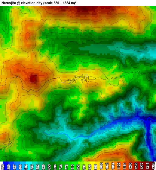
Below is the Elevation map of Naranjito, which displays elevation range with different colors. Scale of the first map is from 350 to 1354 m (1148 to 4442 ft) with average elevation of 819 meters (=2687 ft) [note 1]
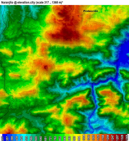
These maps also provides idea of topography and contour of this city, they are displayed at different zoom levels. More info about maps, scale and edge coordinates you can find below images.
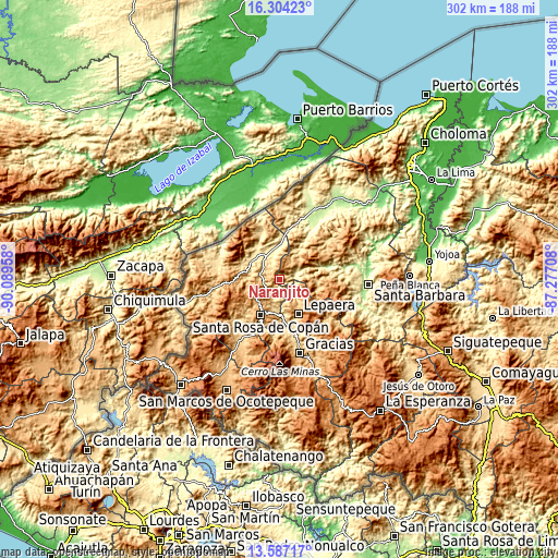
| \ | Map #1 | Map #2 | Topo.Map |
| Scale [m] | 350..1354 m | 317..1368 m | × |
| Scale [ft] | 1148..4442 ft | 1040..4488 ft | × |
| Average | 819 m = 2687 ft | 791.9 m = 2598 ft | × |
| Width | 9.44 km = 5.9 mi | 18.88 km = 11.7 mi | 302.1 km = 187.7 mi |
| Height | 9.44 km = 5.9 mi | 18.88 km = 11.7 mi | 302.1 km = 187.7 mi |
| ↑Max Latitude | 14.992454° | 15.034899° | 16.30423° |
| Latitude at center | 14.95° | 14.95° | 14.95° |
| ↓Min Latitude | 14.907538° | 14.865068° | 13.58717° |
| ← Min Longitude | -88.727275° | -88.771221° | -90.08958° |
| Longitude center | -88.68333° | -88.68333° | -88.68333° |
| →Max Longitude | -88.639385° | -88.595439° | -87.27708° |
Nearby cities:
Cities around Naranjito sort by population:
• La Entrada elevation 509 m
12.3 km,  334°
334°
• Trinidad de Copán 797 m
7.2 km,  270°
270°
• San Nicolás 724 m
9.1 km,  307°
307°
• Protección 920 m
9.9 km,  21°
21°
• Chalmeca 485 m
16.7 km,  0°
0°
• San José de Copán 693 m
6.6 km,  212°
212°
• Quezailica 669 m
9.2 km,  215°
215°
• Agua Caliente 932 m
16.1 km,  242°
242°
• Pueblo Nuevo 724 m
9.1 km, 307°
• San Juan de Planes 793 m
10.9 km,  260°
260°
• Veracruz 1128 m
11.4 km,  250°
250°
• El Corozal 619 m
14.8 km,  28°
28°
Multilingual:
 En español:
Naranjito elevación 921 m.
 En France:
Naranjito élévation 921 m.
 Auf Deutsch:
Naranjito höhe über dem Meeresspiegel ist 921 m.

Sources and notes:
- [note 1] Map square and city borders are not equal. Map elevation data is calculated only from area inside that square.
- [src 1] Elevation data from geonames database provided with same terms of usage.
- [src 2] The elevation map of Naranjito is generated using elevation data from NASA's 3 arcsec (90m) resolution SRTM data.
- [src 3] Base (background) map © OpenStreetMap contributors tiles are generated by Geofabrik and OpenTopoMap.
Copyright & License:
This Naranjito Elevation Map is licensed under CC BY-SA. You may reuse any part from this page, if you give a proper credit by linking to this URL:
 More info on terms of use page.