La Entrada elevation
La Entrada (Copán), Honduras elevation is 509 meters and La Entrada elevation in feet is 1670 ft above sea level [src 1]. La Entrada is a populated place (feature code) with elevation that is 34 meters (112 ft) smaller than average city elevation in Honduras.
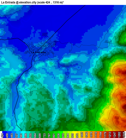
Below is the Elevation map of La Entrada, which displays elevation range with different colors. Scale of the first map is from 424 to 1316 m (1391 to 4318 ft) with average elevation of 596.5 meters (=1957 ft) [note 1]
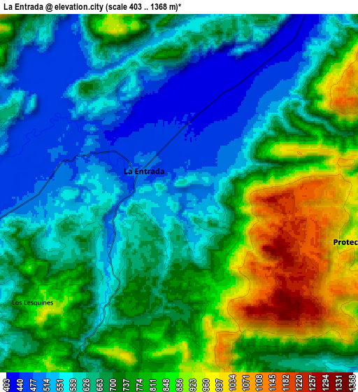
These maps also provides idea of topography and contour of this city, they are displayed at different zoom levels. More info about maps, scale and edge coordinates you can find below images.
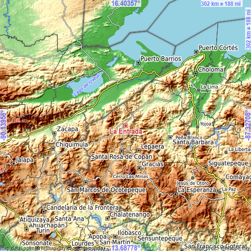
| \ | Map #1 | Map #2 | Topo.Map |
| Scale [m] | 424..1316 m | 403..1368 m | × |
| Scale [ft] | 1391..4318 ft | 1322..4488 ft | × |
| Average | 596.5 m = 1957 ft | 700.4 m = 2298 ft | × |
| Width | 9.44 km = 5.9 mi | 18.87 km = 11.7 mi | 302 km = 187.7 mi |
| Height | 9.44 km = 5.9 mi | 18.87 km = 11.7 mi | 302 km = 187.7 mi |
| ↑Max Latitude | 15.092434° | 15.134859° | 16.40357° |
| Latitude at center | 15.05° | 15.05° | 15.05° |
| ↓Min Latitude | 15.007558° | 14.965107° | 13.68778° |
| ← Min Longitude | -88.777275° | -88.821221° | -90.13958° |
| Longitude center | -88.73333° | -88.73333° | -88.73333° |
| →Max Longitude | -88.689385° | -88.645439° | -87.32708° |
Nearby cities:
Cities around La Entrada sort by population:
• Florida elevation 486 m
10.9 km,  260°
260°
• Naranjito 921 m
12.3 km,  154°
154°
• Trinidad de Copán 797 m
11.3 km,  189°
189°
• San Nicolás 724 m
5.8 km,  197°
197°
• Protección 920 m
9.1 km,  101°
101°
• Chalmeca 485 m
7.7 km,  43°
43°
• Los Tangos 437 m
12.3 km,  25°
25°
• Pueblo Nuevo 724 m
5.8 km, 197°
• San Juan de Planes 793 m
14 km, 202°
• El Corozal 619 m
12.7 km,  81°
81°
• Callejones 455 m
15.8 km, 34°
• Concepción de la Barranca 969 m
13.1 km,  7°
7°
Multilingual:
 En español:
La Entrada elevación 509 m.
 En France:
La Entrada élévation 509 m.
 Auf Deutsch:
La Entrada höhe über dem Meeresspiegel ist 509 m.

Sources and notes:
- [note 1] Map square and city borders are not equal. Map elevation data is calculated only from area inside that square.
- [src 1] Elevation data from geonames database provided with same terms of usage.
- [src 2] The elevation map of La Entrada is generated using elevation data from NASA's 3 arcsec (90m) resolution SRTM data.
- [src 3] Base (background) map © OpenStreetMap contributors tiles are generated by Geofabrik and OpenTopoMap.
Copyright & License:
This La Entrada Elevation Map is licensed under CC BY-SA. You may reuse any part from this page, if you give a proper credit by linking to this URL:
 More info on terms of use page.