Florida elevation
Florida (Copán), Honduras elevation is 486 meters and Florida elevation in feet is 1594 ft above sea level [src 1]. Florida is a populated place (feature code) with elevation that is 57 meters (187 ft) smaller than average city elevation in Honduras.
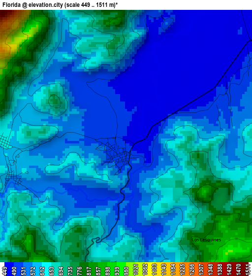
Below is the Elevation map of Florida, which displays elevation range with different colors. Scale of the first map is from 449 to 1511 m (1473 to 4957 ft) with average elevation of 610.9 meters (=2004 ft) [note 1]
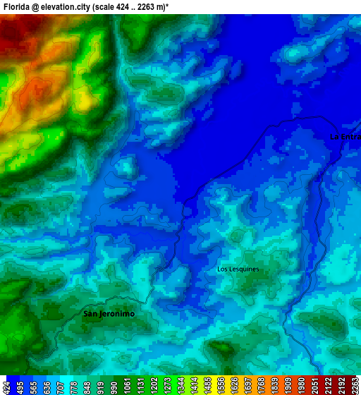
These maps also provides idea of topography and contour of this city, they are displayed at different zoom levels. More info about maps, scale and edge coordinates you can find below images.
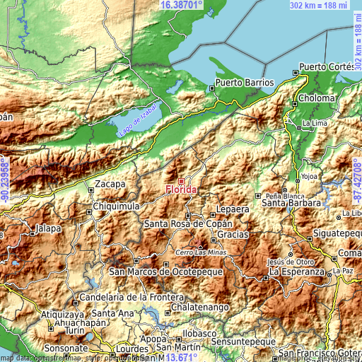
| \ | Map #1 | Map #2 | Topo.Map |
| Scale [m] | 449..1511 m | 424..2263 m | × |
| Scale [ft] | 1473..4957 ft | 1391..7425 ft | × |
| Average | 610.9 m = 2004 ft | 785.1 m = 2576 ft | × |
| Width | 9.44 km = 5.9 mi | 18.88 km = 11.7 mi | 302 km = 187.7 mi |
| Height | 9.44 km = 5.9 mi | 18.88 km = 11.7 mi | 302 km = 187.7 mi |
| ↑Max Latitude | 15.075767° | 15.118196° | 16.38701° |
| Latitude at center | 15.03333° | 15.03333° | 15.03333° |
| ↓Min Latitude | 14.990884° | 14.948431° | 13.671° |
| ← Min Longitude | -88.877275° | -88.921221° | -90.23958° |
| Longitude center | -88.83333° | -88.83333° | -88.83333° |
| →Max Longitude | -88.789385° | -88.745439° | -87.42708° |
Nearby cities:
Cities around Florida sort by population:
• La Entrada elevation 509 m
10.9 km,  80°
80°
• Trinidad de Copán 797 m
12.9 km,  135°
135°
• San Nicolás 724 m
9.7 km,  112°
112°
• Buenos Aires 956 m
14.3 km,  270°
270°
• San Joaquín 1235 m
7.4 km,  284°
284°
• La Zumbadora 691 m
7.4 km,  255°
255°
• Agua Caliente 932 m
16.8 km,  173°
173°
• Pueblo Nuevo 724 m
9.7 km, 112°
• San Juan de Planes 793 m
12.3 km,  154°
154°
• San Jerónimo 793 m
8.2 km,  205°
205°
• Veracruz 1128 m
14 km,  157°
157°
• El Ocotón 701 m
5.4 km, 270°
Multilingual:
 En español:
Florida elevación 486 m.
 En France:
Florida élévation 486 m.


Sources and notes:
- [note 1] Map square and city borders are not equal. Map elevation data is calculated only from area inside that square.
- [src 1] Elevation data from geonames database provided with same terms of usage.
- [src 2] The elevation map of Florida is generated using elevation data from NASA's 3 arcsec (90m) resolution SRTM data.
- [src 3] Base (background) map © OpenStreetMap contributors tiles are generated by Geofabrik and OpenTopoMap.
Copyright & License:
This Florida Elevation Map is licensed under CC BY-SA. You may reuse any part from this page, if you give a proper credit by linking to this URL:
 More info on terms of use page.