Santa Rosa de Copán elevation
Santa Rosa de Copán (Copán), Honduras elevation is 1146 meters and Santa Rosa de Copán elevation in feet is 3760 ft above sea level [src 1]. Santa Rosa de Copán is a seat of a first-order administrative division (feature code) with elevation that is 603 meters (1978 ft) bigger than average city elevation in Honduras.
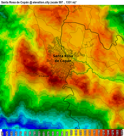
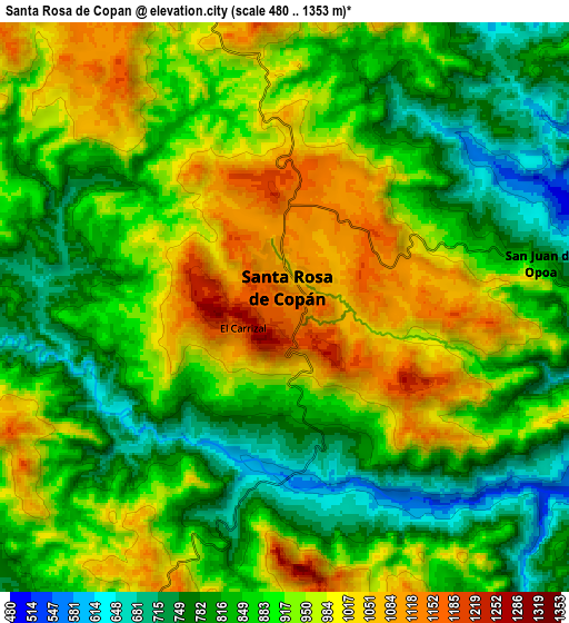
Below is the Elevation map of Santa Rosa de Copán, which displays elevation range with different colors. Scale of the first map is from 597 to 1331 m (1959 to 4367 ft) with average elevation of 1025.5 meters (=3365 ft) [note 1]
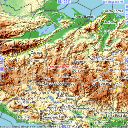
These maps also provides idea of topography and contour of this city, they are displayed at different zoom levels. More info about maps, scale and edge coordinates you can find below images.
| \ | Map #1 | Map #2 | Topo.Map |
| Scale [m] | 597..1331 m | 480..1353 m | × |
| Scale [ft] | 1959..4367 ft | 1575..4439 ft | × |
| Average | 1025.5 m = 3365 ft | 896.7 m = 2942 ft | × |
| Width | 9.45 km = 5.9 mi | 18.9 km = 11.7 mi | 302.4 km = 187.9 mi |
| Height | 9.45 km = 5.9 mi | 18.9 km = 11.7 mi | 302.4 km = 187.9 mi |
| ↑Max Latitude | 14.80916° | 14.851641° | 16.1221° |
| Latitude at center | 14.76667° | 14.76667° | 14.76667° |
| ↓Min Latitude | 14.724172° | 14.681666° | 13.40273° |
| ← Min Longitude | -88.823115° | -88.867061° | -90.18542° |
| Longitude center | -88.77917° | -88.77917° | -88.77917° |
| →Max Longitude | -88.735225° | -88.691279° | -87.37292° |
Nearby cities:
Cities around Santa Rosa de Copán sort by population:
• Dulce Nombre elevation 1109 m
10.9 km,  327°
327°
• Cucuyagua 775 m
16 km,  215°
215°
• San José de Copán 693 m
16.3 km,  24°
24°
• San Agustín 1221 m
17.5 km,  288°
288°
• San Juan de Opoa 743 m
8.7 km,  77°
77°
• Ojos de Agua 895 m
8.4 km,  208°
208°
• El Corpus 807 m
16.5 km,  243°
243°
• Quezailica 669 m
13.9 km, 20°
• Dolores 1202 m
12.6 km, 332°
• Agua Caliente 932 m
13.6 km,  342°
342°
• San Juan de Planes 793 m
18.5 km,  358°
358°
• Veracruz 1128 m
16.7 km, 358°
Multilingual:
 En español:
Santa Rosa de Copán elevación 1146 m.
 En France:
Santa Rosa de Copán élévation 1146 m.
 Auf Deutsch:
Santa Rosa de Copán höhe über dem Meeresspiegel ist 1146 m.
 На русском:
Санта-Роса-де-Копан высота над уровнем моря 1146 м
Sources and notes:
- [note 1] Map square and city borders are not equal. Map elevation data is calculated only from area inside that square.
- [src 1] Elevation data from geonames database provided with same terms of usage.
- [src 2] The elevation map of Santa Rosa de Copán is generated using elevation data from NASA's 3 arcsec (90m) resolution SRTM data.
- [src 3] Base (background) map © OpenStreetMap contributors tiles are generated by Geofabrik and OpenTopoMap.
Copyright & License:
This Santa Rosa de Copán Elevation Map is licensed under CC BY-SA. You may reuse any part from this page, if you give a proper credit by linking to this URL:
 More info on terms of use page.