Cucuyagua elevation
Cucuyagua (Copán), Honduras elevation is 775 meters and Cucuyagua elevation in feet is 2543 ft above sea level [src 1]. Cucuyagua is a populated place (feature code) with elevation that is 232 meters (761 ft) bigger than average city elevation in Honduras.
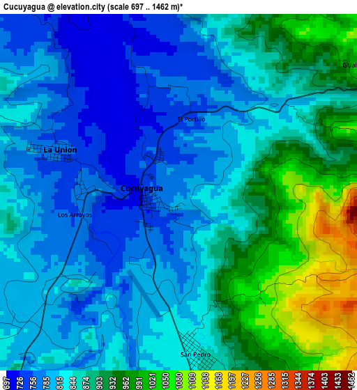
Below is the Elevation map of Cucuyagua, which displays elevation range with different colors. Scale of the first map is from 697 to 1462 m (2287 to 4797 ft) with average elevation of 857.7 meters (=2814 ft) [note 1]
These maps also provides idea of topography and contour of this city, they are displayed at different zoom levels. More info about maps, scale and edge coordinates you can find below images.
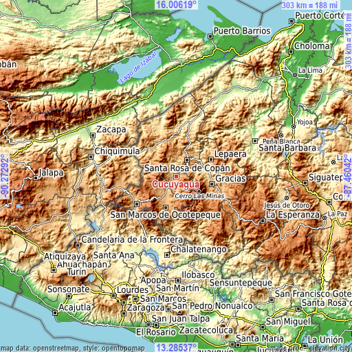
| \ | Map #1 | Topo.Map |
| Scale [m] | 697..1462 m | × |
| Scale [ft] | 2287..4797 ft | × |
| Average | 857.7 m = 2814 ft | × |
| Width | 9.45 km = 5.9 mi | 302.5 km = 188 mi |
| Height | 9.45 km = 5.9 mi | 302.6 km = 188 mi |
| ↑Max Latitude | 14.692512° | 16.00619° |
| Latitude at center | 14.65° | 14.65° |
| ↓Min Latitude | 14.607479° | 13.28537° |
| ← Min Longitude | -88.910615° | -90.27292° |
| Longitude center | -88.86667° | -88.86667° |
| →Max Longitude | -88.822725° | -87.46042° |
Nearby cities:
Cities around Cucuyagua sort by population:
• Santa Rosa de Copán elevation 1146 m
16 km,  35°
35°
• Corquín 909 m
9.3 km,  180°
180°
• Dulce Nombre 1109 m
22.5 km,  9°
9°
• Belén Gualcho 1783 m
19.9 km,  158°
158°
• San Agustín 1221 m
19.9 km,  338°
338°
• San Juan de Opoa 743 m
23.3 km,  50°
50°
• Sensenti 872 m
19.9 km,  201°
201°
• Lucerna 842 m
13.2 km,  212°
212°
• Ojos de Agua 895 m
7.7 km, 44°
• El Corpus 807 m
7.7 km,  315°
315°
• Yaruchel 1374 m
14 km, 157°
• San Francisco de Cones 1218 m
15.3 km,  193°
193°
Multilingual:
 En español:
Cucuyagua elevación 775 m.
 En France:
Cucuyagua élévation 775 m.
 Auf Deutsch:
Cucuyagua höhe über dem Meeresspiegel ist 775 m.

Sources and notes:
- [note 1] Map square and city borders are not equal. Map elevation data is calculated only from area inside that square.
- [src 1] Elevation data from geonames database provided with same terms of usage.
- [src 2] The elevation map of Cucuyagua is generated using elevation data from NASA's 3 arcsec (90m) resolution SRTM data.
- [src 3] Base (background) map © OpenStreetMap contributors tiles are generated by Geofabrik and OpenTopoMap.
Copyright & License:
This Cucuyagua Elevation Map is licensed under CC BY-SA. You may reuse any part from this page, if you give a proper credit by linking to this URL:
 More info on terms of use page.