Tiquisate elevation
Tiquisate (Escuintla, Município de Tiquisate), Guatemala elevation is 71 meters and Tiquisate elevation in feet is 233 ft above sea level [src 1]. Tiquisate is a populated place (feature code) with elevation that is 1196 meters (3924 ft) smaller than average city elevation in Guatemala.
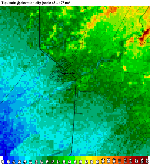
Below is the Elevation map of Tiquisate, which displays elevation range with different colors. Scale of the first map is from 45 to 127 m (148 to 417 ft) with average elevation of 70.4 meters (=231 ft) [note 1]
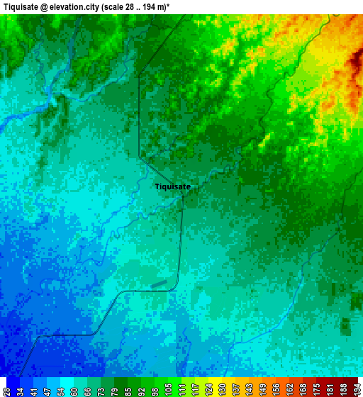
These maps also provides idea of topography and contour of this city, they are displayed at different zoom levels. More info about maps, scale and edge coordinates you can find below images.
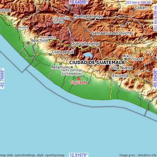
| \ | Map #1 | Map #2 | Topo.Map |
| Scale [m] | 45..127 m | 28..194 m | × |
| Scale [ft] | 148..417 ft | 92..636 ft | × |
| Average | 70.4 m = 231 ft | 73.6 m = 241 ft | × |
| Width | 9.47 km = 5.9 mi | 18.94 km = 11.8 mi | 303 km = 188.3 mi |
| Height | 9.47 km = 5.9 mi | 18.94 km = 11.8 mi | 303.1 km = 188.3 mi |
| ↑Max Latitude | 14.326143° | 14.368717° | 15.64209° |
| Latitude at center | 14.28356° | 14.28356° | 14.28356° |
| ↓Min Latitude | 14.240969° | 14.19837° | 12.91678° |
| ← Min Longitude | -91.404575° | -91.448521° | -92.76688° |
| Longitude center | -91.36063° | -91.36063° | -91.36063° |
| →Max Longitude | -91.316685° | -91.272739° | -89.95438° |
Nearby cities:
Cities around Tiquisate sort by population:
• Chicacao elevation 505 m
29.1 km,  7°
7°
• Patulul 342 m
26.6 km,  54°
54°
• Santa Bárbara 405 m
22.2 km,  40°
40°
• Nueva Concepción 58 m
11.4 km,  144°
144°
• San Antonio Suchitepéquez 389 m
29 km,  348°
348°
• Río Bravo 161 m
13.8 km,  19°
19°
• Santo Domingo Suchitepéquez 230 m
25.4 km,  328°
328°
• San Juan Bautista 291 m
24.9 km, 51°
• San José El Ídolo 183 m
19.7 km,  340°
340°
• San Lorenzo 224 m
27.8 km,  323°
323°
• San Miguel Panán 389 m
27.3 km,  358°
358°
• La Máquina 63 m
22.3 km,  275°
275°
Multilingual:
 En español:
Tiquisate elevación 71 m.
 En France:
Tiquisate élévation 71 m.
 Auf Deutsch:
Tiquisate höhe über dem Meeresspiegel ist 71 m.

Sources and notes:
- [note 1] Map square and city borders are not equal. Map elevation data is calculated only from area inside that square.
- [src 1] Elevation data from geonames database provided with same terms of usage.
- [src 2] The elevation map of Tiquisate is generated using elevation data from NASA's 3 arcsec (90m) resolution SRTM data.
- [src 3] Base (background) map © OpenStreetMap contributors tiles are generated by Geofabrik and OpenTopoMap.
Copyright & License:
This Tiquisate Elevation Map is licensed under CC BY-SA. You may reuse any part from this page, if you give a proper credit by linking to this URL:
 More info on terms of use page.