La Máquina elevation
La Máquina (Suchitepeque), Guatemala elevation is 63 meters and La Máquina elevation in feet is 207 ft above sea level [src 1]. La Máquina is a seat of a second-order administrative division (feature code) with elevation that is 1204 meters (3950 ft) smaller than average city elevation in Guatemala.
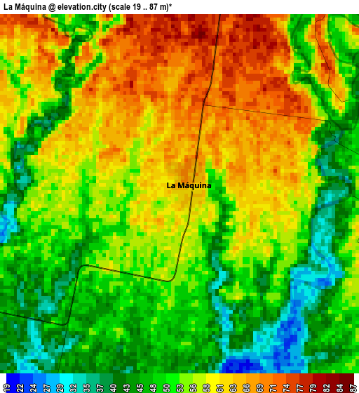
Below is the Elevation map of La Máquina, which displays elevation range with different colors. Scale of the first map is from 19 to 87 m (62 to 285 ft) with average elevation of 54.6 meters (=179 ft) [note 1]
These maps also provides idea of topography and contour of this city, they are displayed at different zoom levels. More info about maps, scale and edge coordinates you can find below images.
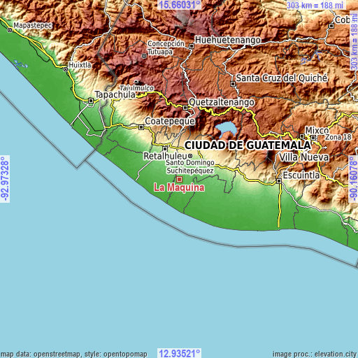
| \ | Map #1 | Topo.Map |
| Scale [m] | 19..87 m | × |
| Scale [ft] | 62..285 ft | × |
| Average | 54.6 m = 179 ft | × |
| Width | 9.47 km = 5.9 mi | 303 km = 188.3 mi |
| Height | 9.47 km = 5.9 mi | 303 km = 188.3 mi |
| ↑Max Latitude | 14.344469° | 15.66031° |
| Latitude at center | 14.30189° | 14.30189° |
| ↓Min Latitude | 14.259303° | 12.93521° |
| ← Min Longitude | -91.610975° | -92.97328° |
| Longitude center | -91.56703° | -91.56703° |
| →Max Longitude | -91.523085° | -90.16078° |
Nearby cities:
Cities around La Máquina sort by population:
• Mazatenango elevation 373 m
26.7 km,  14°
14°
• Retalhuleu 241 m
28.6 km,  335°
335°
• Tiquisate 71 m
22.3 km,  95°
95°
• San Sebastián 310 m
30.2 km, 343°
• Cuyotenango 336 m
26.5 km,  358°
358°
• Río Bravo 161 m
29.1 km,  67°
67°
• Santo Domingo Suchitepéquez 230 m
21.7 km,  24°
24°
• San Bernardino 439 m
29.2 km, 23°
• San Andrés Villa Seca 453 m
30.8 km, 356°
• San Gabriel 285 m
24.1 km, 15°
• San José El Ídolo 183 m
22.7 km,  43°
43°
• San Lorenzo 224 m
21.3 km, 15°
Multilingual:
 En español:
San José La Máquina, La Máquina elevación 63 m.
 En France:
La Máquina élévation 63 m.
 Auf Deutsch:
La Máquina höhe über dem Meeresspiegel ist 63 m.

Sources and notes:
- [note 1] Map square and city borders are not equal. Map elevation data is calculated only from area inside that square.
- [src 1] Elevation data from geonames database provided with same terms of usage.
- [src 2] The elevation map of La Máquina is generated using elevation data from NASA's 3 arcsec (90m) resolution SRTM data.
- [src 3] Base (background) map © OpenStreetMap contributors tiles are generated by Geofabrik and OpenTopoMap.
Copyright & License:
This La Máquina Elevation Map is licensed under CC BY-SA. You may reuse any part from this page, if you give a proper credit by linking to this URL:
 More info on terms of use page.