Santo Domingo Suchitepéquez elevation
Santo Domingo Suchitepéquez (Suchitepeque), Guatemala elevation is 230 meters and Santo Domingo Suchitepéquez elevation in feet is 755 ft above sea level [src 1]. Santo Domingo Suchitepéquez is a seat of a second-order administrative division (feature code) with elevation that is 1037 meters (3402 ft) smaller than average city elevation in Guatemala.
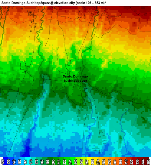
Below is the Elevation map of Santo Domingo Suchitepéquez, which displays elevation range with different colors. Scale of the first map is from 126 to 353 m (413 to 1158 ft) with average elevation of 223.3 meters (=733 ft) [note 1]
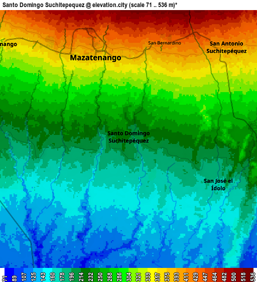
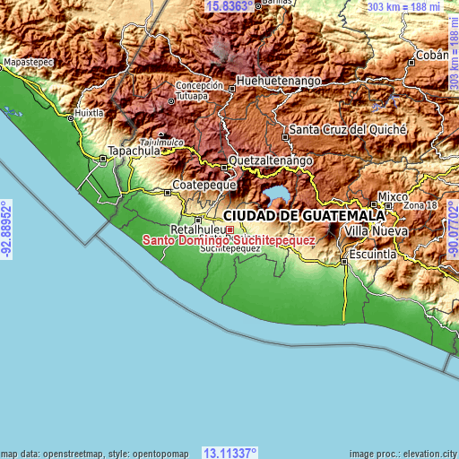
These maps also provides idea of topography and contour of this city, they are displayed at different zoom levels. More info about maps, scale and edge coordinates you can find below images.
| \ | Map #1 | Map #2 | Topo.Map |
| Scale [m] | 126..353 m | 71..536 m | × |
| Scale [ft] | 413..1158 ft | 233..1759 ft | × |
| Average | 223.3 m = 733 ft | 247.4 m = 812 ft | × |
| Width | 9.46 km = 5.9 mi | 18.92 km = 11.8 mi | 302.8 km = 188.2 mi |
| Height | 9.46 km = 5.9 mi | 18.92 km = 11.8 mi | 302.8 km = 188.2 mi |
| ↑Max Latitude | 14.521555° | 14.564093° | 15.8363° |
| Latitude at center | 14.47901° | 14.47901° | 14.47901° |
| ↓Min Latitude | 14.436456° | 14.393895° | 13.11337° |
| ← Min Longitude | -91.527215° | -91.571161° | -92.88952° |
| Longitude center | -91.48327° | -91.48327° | -91.48327° |
| →Max Longitude | -91.439325° | -91.395379° | -90.07702° |
Nearby cities:
Cities around Santo Domingo Suchitepéquez sort by population:
• Mazatenango elevation 373 m
6.5 km,  340°
340°
• San Pablo Jocopilas 663 m
12.7 km,  15°
15°
• San Francisco Zapotitlán 600 m
12.9 km, 341°
• San Antonio Suchitepéquez 389 m
10 km,  47°
47°
• Cuyotenango 336 m
11.7 km,  305°
305°
• Samayac 621 m
11.6 km,  11°
11°
• San Bernardino 439 m
7.6 km, 21°
• San Gabriel 285 m
4.4 km,  323°
323°
• Zunilito 783 m
15.1 km,  349°
349°
• San José El Ídolo 183 m
7.3 km,  116°
116°
• San Lorenzo 224 m
3.3 km,  283°
283°
• San Miguel Panán 389 m
13.6 km,  66°
66°
Multilingual:
 En español:
Santo Domingo Suchitepéquez elevación 230 m.
 En France:
Santo Domingo Suchitepéquez élévation 230 m.
 Auf Deutsch:
Santo Domingo Suchitepéquez höhe über dem Meeresspiegel ist 230 m.
 На русском:
Santo Domingo Suchitepéquez высота над уровнем моря 230 м
Sources and notes:
- [note 1] Map square and city borders are not equal. Map elevation data is calculated only from area inside that square.
- [src 1] Elevation data from geonames database provided with same terms of usage.
- [src 2] The elevation map of Santo Domingo Suchitepéquez is generated using elevation data from NASA's 3 arcsec (90m) resolution SRTM data.
- [src 3] Base (background) map © OpenStreetMap contributors tiles are generated by Geofabrik and OpenTopoMap.
Copyright & License:
This Santo Domingo Suchitepéquez Elevation Map is licensed under CC BY-SA. You may reuse any part from this page, if you give a proper credit by linking to this URL:
 More info on terms of use page.