San Antonio Suchitepéquez elevation
San Antonio Suchitepéquez (Suchitepeque, Municipio de San Antonio Suchitepéquez), Guatemala elevation is 389 meters and San Antonio Suchitepéquez elevation in feet is 1276 ft above sea level [src 1]. San Antonio Suchitepéquez is a seat of a second-order administrative division (feature code) with elevation that is 878 meters (2881 ft) smaller than average city elevation in Guatemala.
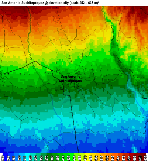
Below is the Elevation map of San Antonio Suchitepéquez, which displays elevation range with different colors. Scale of the first map is from 252 to 635 m (827 to 2083 ft) with average elevation of 410.8 meters (=1348 ft) [note 1]
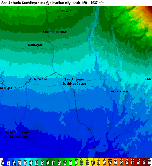
These maps also provides idea of topography and contour of this city, they are displayed at different zoom levels. More info about maps, scale and edge coordinates you can find below images.
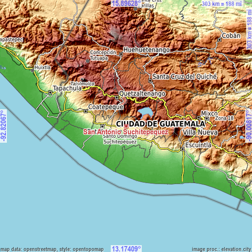
| \ | Map #1 | Map #2 | Topo.Map |
| Scale [m] | 252..635 m | 160..1937 m | × |
| Scale [ft] | 827..2083 ft | 525..6355 ft | × |
| Average | 410.8 m = 1348 ft | 471.3 m = 1546 ft | × |
| Width | 9.46 km = 5.9 mi | 18.92 km = 11.8 mi | 302.7 km = 188.1 mi |
| Height | 9.46 km = 5.9 mi | 18.92 km = 11.8 mi | 302.7 km = 188.1 mi |
| ↑Max Latitude | 14.581914° | 14.62444° | 15.89628° |
| Latitude at center | 14.53938° | 14.53938° | 14.53938° |
| ↓Min Latitude | 14.496838° | 14.454288° | 13.17409° |
| ← Min Longitude | -91.458365° | -91.502311° | -92.82067° |
| Longitude center | -91.41442° | -91.41442° | -91.41442° |
| →Max Longitude | -91.370475° | -91.326529° | -90.00817° |
Nearby cities:
Cities around San Antonio Suchitepéquez sort by population:
• Mazatenango elevation 373 m
9.6 km,  266°
266°
• Chicacao 505 m
9.5 km,  87°
87°
• San Pablo Jocopilas 663 m
6.8 km,  323°
323°
• San Francisco Zapotitlán 600 m
12.8 km,  295°
295°
• Samayac 621 m
6.8 km,  312°
312°
• Santo Tomás La Unión 870 m
10.3 km,  2°
2°
• Santo Domingo Suchitepéquez 230 m
10 km,  227°
227°
• San Bernardino 439 m
4.7 km, 274°
• San Gabriel 285 m
10.5 km,  252°
252°
• San José El Ídolo 183 m
10 km,  184°
184°
• San Lorenzo 224 m
12.1 km,  240°
240°
• San Miguel Panán 389 m
5.2 km,  103°
103°
Multilingual:
 En español:
San Antonio Suchitepéquez elevación 389 m.
 En France:
San Antonio Suchitepéquez élévation 389 m.
 Auf Deutsch:
San Antonio Suchitepéquez höhe über dem Meeresspiegel ist 389 m.
 На русском:
San Antonio Suchitepéquez высота над уровнем моря 389 м
Sources and notes:
- [note 1] Map square and city borders are not equal. Map elevation data is calculated only from area inside that square.
- [src 1] Elevation data from geonames database provided with same terms of usage.
- [src 2] The elevation map of San Antonio Suchitepéquez is generated using elevation data from NASA's 3 arcsec (90m) resolution SRTM data.
- [src 3] Base (background) map © OpenStreetMap contributors tiles are generated by Geofabrik and OpenTopoMap.
Copyright & License:
This San Antonio Suchitepéquez Elevation Map is licensed under CC BY-SA. You may reuse any part from this page, if you give a proper credit by linking to this URL:
 More info on terms of use page.