Kpandu elevation
Kpandu (Volta), Ghana elevation is 153 meters and Kpandu elevation in feet is 502 ft above sea level [src 1]. Kpandu is a populated place (feature code) with elevation that is 17 meters (56 ft) smaller than average city elevation in Ghana.
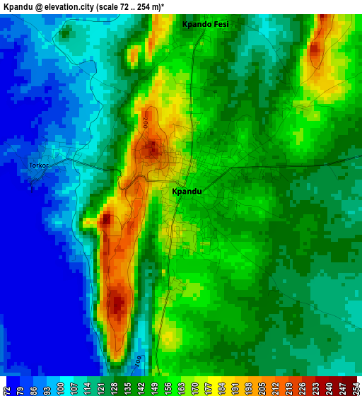
Below is the Elevation map of Kpandu, which displays elevation range with different colors. Scale of the first map is from 72 to 254 m (236 to 833 ft) with average elevation of 130.8 meters (=429 ft) [note 1]
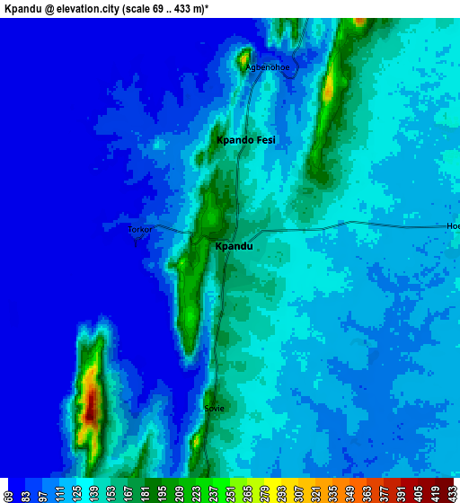
These maps also provides idea of topography and contour of this city, they are displayed at different zoom levels. More info about maps, scale and edge coordinates you can find below images.
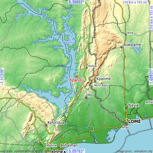
| \ | Map #1 | Map #2 | Topo.Map |
| Scale [m] | 72..254 m | 69..433 m | × |
| Scale [ft] | 236..833 ft | 226..1421 ft | × |
| Average | 130.8 m = 429 ft | 114.7 m = 376 ft | × |
| Width | 9.7 km = 6 mi | 19.4 km = 12.1 mi | 310.4 km = 192.9 mi |
| Height | 9.7 km = 6 mi | 19.4 km = 12.1 mi | 310.4 km = 192.9 mi |
| ↑Max Latitude | 7.038976° | 7.082588° | 8.38892° |
| Latitude at center | 6.99536° | 6.99536° | 6.99536° |
| ↓Min Latitude | 6.95174° | 6.908116° | 5.59763° |
| ← Min Longitude | 0.249115° | 0.205169° | -1.11319° |
| Longitude center | 0.29306° | 0.29306° | 0.29306° |
| →Max Longitude | 0.337005° | 0.380951° | 1.69931° |
Nearby cities:
Cities around Kpandu sort by population:
• Koforidua elevation 172 m
117.3 km,  211°
211°
• Ho 171 m
48.1 km,  155°
155°
• Aflao 9 m
138.9 km,  134°
134°
• Hohoe 173 m
26.4 km,  48°
48°
• Suhum 182 m
134.2 km,  217°
217°
• Begoro 460 m
100.3 km,  227°
227°
• Aburi 447 m
137.6 km,  202°
202°
• Akropong 454 m
121 km, 200°
• Kete Krachi 117 m
96.5 km,  336°
336°
• Kibi 318 m
131.4 km, 225°
• Mpraeso 477 m
122 km,  248°
248°
• Odumase Krobo 214 m
132.9 km, 247°
Multilingual:
 En español:
Kpandu elevación 153 m.
 En France:
Kpandu élévation 153 m.


Sources and notes:
- [note 1] Map square and city borders are not equal. Map elevation data is calculated only from area inside that square.
- [src 1] Elevation data from geonames database provided with same terms of usage.
- [src 2] The elevation map of Kpandu is generated using elevation data from NASA's 3 arcsec (90m) resolution SRTM data.
- [src 3] Base (background) map © OpenStreetMap contributors tiles are generated by Geofabrik and OpenTopoMap.
Copyright & License:
This Kpandu Elevation Map is licensed under CC BY-SA. You may reuse any part from this page, if you give a proper credit by linking to this URL:
 More info on terms of use page.