Ho elevation
Ho (Volta), Ghana elevation is 171 meters and Ho elevation in feet is 561 ft above sea level [src 1]. Ho is a seat of a first-order administrative division (feature code) with elevation that is 1 meters (3 ft) bigger than average city elevation in Ghana.
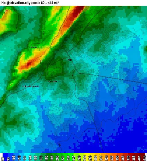
Below is the Elevation map of Ho, which displays elevation range with different colors. Scale of the first map is from 80 to 414 m (262 to 1358 ft) with average elevation of 154.2 meters (=506 ft) [note 1]
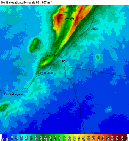
These maps also provides idea of topography and contour of this city, they are displayed at different zoom levels. More info about maps, scale and edge coordinates you can find below images.
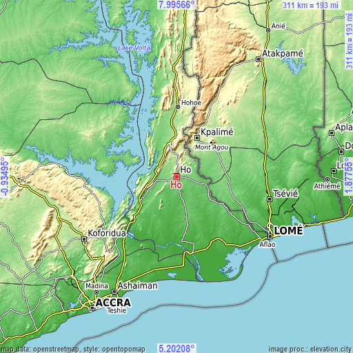
| \ | Map #1 | Map #2 | Topo.Map |
| Scale [m] | 80..414 m | 66..607 m | × |
| Scale [ft] | 262..1358 ft | 217..1991 ft | × |
| Average | 154.2 m = 506 ft | 146.7 m = 481 ft | × |
| Width | 9.71 km = 6 mi | 19.42 km = 12.1 mi | 310.6 km = 193 mi |
| Height | 9.71 km = 6 mi | 19.42 km = 12.1 mi | 310.6 km = 193 mi |
| ↑Max Latitude | 6.644492° | 6.68814° | 7.99566° |
| Latitude at center | 6.60084° | 6.60084° | 6.60084° |
| ↓Min Latitude | 6.557184° | 6.513524° | 5.20208° |
| ← Min Longitude | 0.427355° | 0.383409° | -0.93495° |
| Longitude center | 0.4713° | 0.4713° | 0.4713° |
| →Max Longitude | 0.515245° | 0.559191° | 1.87755° |
Nearby cities:
Cities around Ho sort by population:
• Tema elevation 27 m
116.7 km,  207°
207°
• Koforidua 172 m
98.4 km,  235°
235°
• Aflao 9 m
95.8 km,  123°
123°
• Hohoe 173 m
61.3 km,  0°
0°
• Suhum 182 m
119.3 km, 238°
• Anloga 6 m
101.2 km,  152°
152°
• Begoro 460 m
96.7 km,  255°
255°
• Kpandu 153 m
48.1 km,  335°
335°
• Aburi 447 m
110 km,  220°
220°
• Keta 0 m
95 km,  143°
143°
• Akropong 454 m
92.9 km, 221°
• Kibi 318 m
123.2 km,  246°
246°
Multilingual:
 En español:
Ho elevación 171 m.
 En France:
Ho élévation 171 m.


Sources and notes:
- [note 1] Map square and city borders are not equal. Map elevation data is calculated only from area inside that square.
- [src 1] Elevation data from geonames database provided with same terms of usage.
- [src 2] The elevation map of Ho is generated using elevation data from NASA's 3 arcsec (90m) resolution SRTM data.
- [src 3] Base (background) map © OpenStreetMap contributors tiles are generated by Geofabrik and OpenTopoMap.
Copyright & License:
This Ho Elevation Map is licensed under CC BY-SA. You may reuse any part from this page, if you give a proper credit by linking to this URL:
 More info on terms of use page.