Koforidua elevation
Koforidua (Eastern), Ghana elevation is 172 meters and Koforidua elevation in feet is 564 ft above sea level [src 1]. Koforidua is a seat of a first-order administrative division (feature code) with elevation that is 2 meters (7 ft) bigger than average city elevation in Ghana.
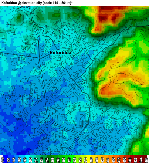
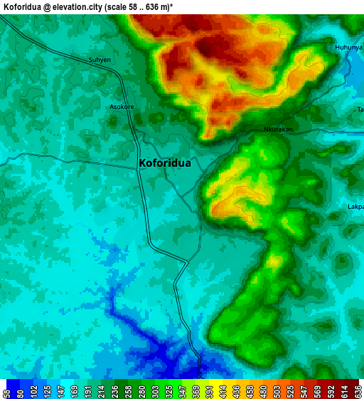
Below is the Elevation map of Koforidua, which displays elevation range with different colors. Scale of the first map is from 114 to 561 m (374 to 1841 ft) with average elevation of 225.4 meters (=740 ft) [note 1]
These maps also provides idea of topography and contour of this city, they are displayed at different zoom levels. More info about maps, scale and edge coordinates you can find below images.
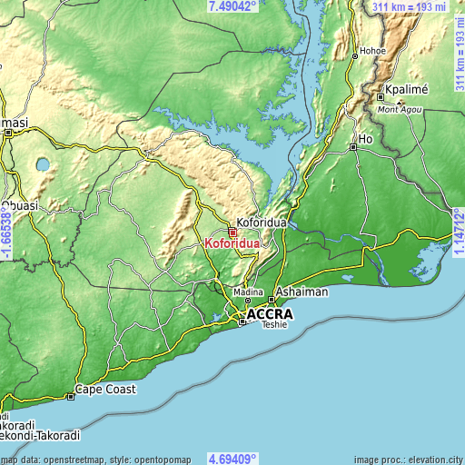
| \ | Map #1 | Map #2 | Topo.Map |
| Scale [m] | 114..561 m | 58..636 m | × |
| Scale [ft] | 374..1841 ft | 190..2087 ft | × |
| Average | 225.4 m = 740 ft | 230.8 m = 757 ft | × |
| Width | 9.72 km = 6 mi | 19.43 km = 12.1 mi | 310.9 km = 193.2 mi |
| Height | 9.72 km = 6 mi | 19.43 km = 12.1 mi | 311 km = 193.2 mi |
| ↑Max Latitude | 6.137775° | 6.181467° | 7.49042° |
| Latitude at center | 6.09408° | 6.09408° | 6.09408° |
| ↓Min Latitude | 6.050381° | 6.006679° | 4.69409° |
| ← Min Longitude | -0.303075° | -0.347021° | -1.66538° |
| Longitude center | -0.25913° | -0.25913° | -0.25913° |
| →Max Longitude | -0.215185° | -0.171239° | 1.14712° |
Nearby cities:
Cities around Koforidua sort by population:
• Atsiaman elevation 45 m
44.7 km,  189°
189°
• Tema 27 m
54.3 km,  150°
150°
• Medina Estates 86 m
48.8 km,  167°
167°
• Suhum 182 m
21.9 km,  254°
254°
• Dome 35 m
49.4 km,  177°
177°
• Gbawe 31 m
57.8 km, 185°
• Nsawam 61 m
33.3 km,  197°
197°
• Asamankese 147 m
51.7 km,  239°
239°
• Begoro 460 m
35.1 km,  338°
338°
• Aburi 447 m
28.9 km,  161°
161°
• Akropong 454 m
23.4 km,  124°
124°
• Kibi 318 m
33.5 km,  283°
283°
Multilingual:
 En español:
Koforidua elevación 172 m.
 En France:
Koforidua élévation 172 m.
 Auf Deutsch:
Koforidua höhe über dem Meeresspiegel ist 172 m.

Sources and notes:
- [note 1] Map square and city borders are not equal. Map elevation data is calculated only from area inside that square.
- [src 1] Elevation data from geonames database provided with same terms of usage.
- [src 2] The elevation map of Koforidua is generated using elevation data from NASA's 3 arcsec (90m) resolution SRTM data.
- [src 3] Base (background) map © OpenStreetMap contributors tiles are generated by Geofabrik and OpenTopoMap.
Copyright & License:
This Koforidua Elevation Map is licensed under CC BY-SA. You may reuse any part from this page, if you give a proper credit by linking to this URL:
 More info on terms of use page.