Kete Krachi elevation
Kete Krachi (Volta, Krachi West), Ghana elevation is 117 meters and Kete Krachi elevation in feet is 384 ft above sea level [src 1]. Kete Krachi is a seat of a second-order administrative division (feature code) with elevation that is 53 meters (174 ft) smaller than average city elevation in Ghana.
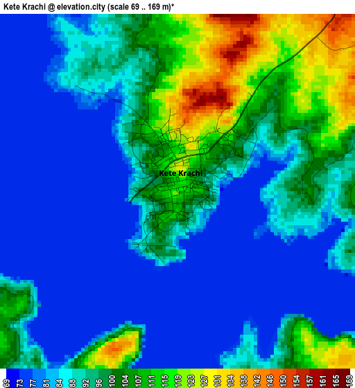
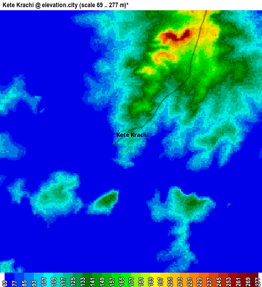
Below is the Elevation map of Kete Krachi, which displays elevation range with different colors. Scale of the first map is from 69 to 169 m (226 to 554 ft) with average elevation of 92.7 meters (=304 ft) [note 1]
These maps also provides idea of topography and contour of this city, they are displayed at different zoom levels. More info about maps, scale and edge coordinates you can find below images.
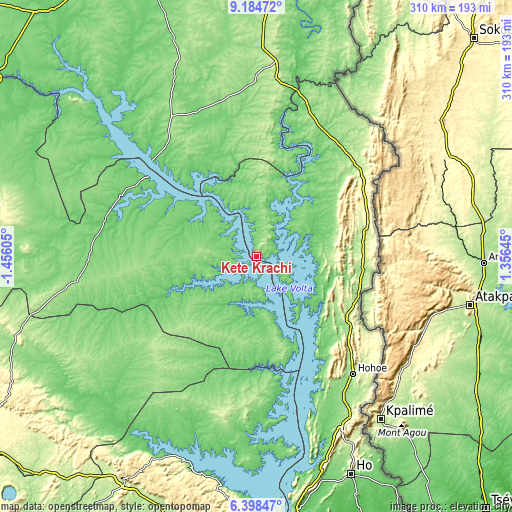
| \ | Map #1 | Map #2 | Topo.Map |
| Scale [m] | 69..169 m | 69..277 m | × |
| Scale [ft] | 226..554 ft | 226..909 ft | × |
| Average | 92.7 m = 304 ft | 94.2 m = 309 ft | × |
| Width | 9.68 km = 6 mi | 19.36 km = 12 mi | 309.8 km = 192.5 mi |
| Height | 9.68 km = 6 mi | 19.36 km = 12 mi | 309.8 km = 192.5 mi |
| ↑Max Latitude | 7.837447° | 7.88098° | 9.18472° |
| Latitude at center | 7.79391° | 7.79391° | 7.79391° |
| ↓Min Latitude | 7.750368° | 7.706822° | 6.39847° |
| ← Min Longitude | -0.093745° | -0.137691° | -1.45605° |
| Longitude center | -0.0498° | -0.0498° | -0.0498° |
| →Max Longitude | -0.005855° | 0.038091° | 1.35645° |
Nearby cities:
Cities around Kete Krachi sort by population:
• Ejura elevation 224 m
151 km,  252°
252°
• Ho 171 m
144.6 km,  156°
156°
• Hohoe 173 m
91.8 km,  141°
141°
• Yendi 208 m
183.4 km,  1°
1°
• Mampong 395 m
169.6 km,  241°
241°
• Agogo 418 m
158.6 km,  225°
225°
• Begoro 460 m
160.5 km,  193°
193°
• Kpandu 153 m
96.5 km, 156°
• Salaga 163 m
98.7 km,  328°
328°
• Mpraeso 477 m
153.4 km,  209°
209°
• Kpandae 183 m
75.2 km, 3°
• Odumase Krobo 214 m
163.7 km, 211°
Multilingual:
 En español:
Kete Krachi elevación 117 m.
 En France:
Kete Krachi élévation 117 m.
 Auf Deutsch:
Kete-Kratschi höhe über dem Meeresspiegel ist 117 m.

Sources and notes:
- [note 1] Map square and city borders are not equal. Map elevation data is calculated only from area inside that square.
- [src 1] Elevation data from geonames database provided with same terms of usage.
- [src 2] The elevation map of Kete Krachi is generated using elevation data from NASA's 3 arcsec (90m) resolution SRTM data.
- [src 3] Base (background) map © OpenStreetMap contributors tiles are generated by Geofabrik and OpenTopoMap.
Copyright & License:
This Kete Krachi Elevation Map is licensed under CC BY-SA. You may reuse any part from this page, if you give a proper credit by linking to this URL:
 More info on terms of use page.